Ethno-Religious Map of Suwayda Governorate

David Chen
Data Visualization Specialist
David Chen is an expert in transforming complex geographic datasets into compelling visual narratives. He combines his background in computer science ...
Geographic Analysis
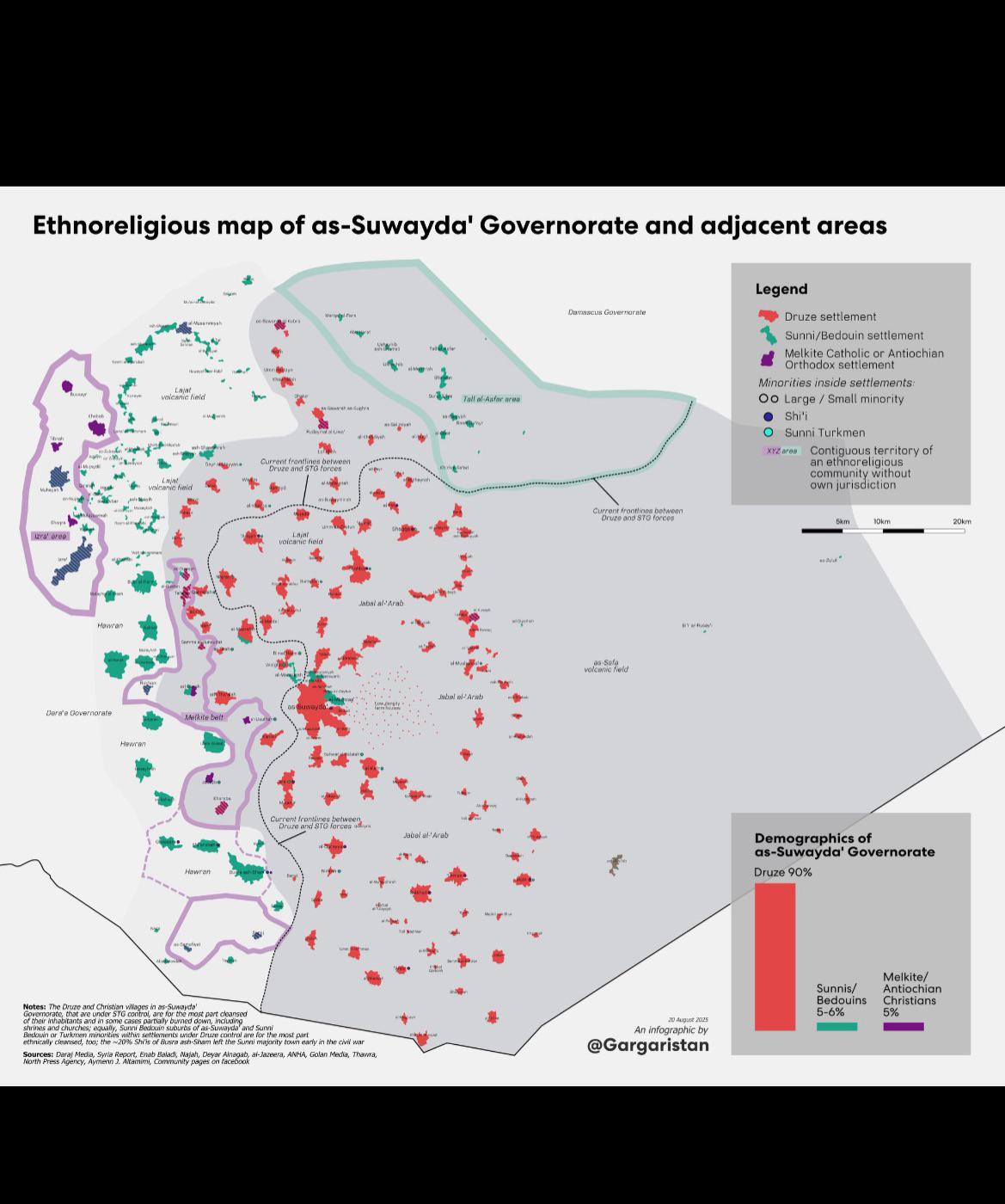
What This Map Shows\nThe ethno-religious map of the Syrian Governorate of Suwayda and its adjacent territories provides a detailed visualization of the region's complex demographic landscape. This map highlights the distribution of various ethnic and religious groups, showcasing how these communities are interspersed across the area. With a focus on the Druze population, the map also illustrates the presence of other groups, including Christians and Sunni Muslims. Understanding this ethno-religious composition is crucial for grasping the social dynamics and historical context of the region.
Deep Dive into Ethno-Religious Dynamics\nSuwayda, located in southwestern Syria, is predominantly home to the Druze community, which accounts for a significant portion of the population. The Druze are an Arabic-speaking ethnoreligious group that emerged in the 11th century from Ismaili Islam, incorporating elements from various philosophical and religious traditions. Interestingly, the Druze community in Suwayda is known for its unique social structure and governance, which has allowed them to maintain a degree of autonomy, especially during times of national instability.
In addition to the Druze, the region also hosts a variety of Christian denominations, including Greek Orthodox and Greek Catholic communities. These groups historically coexisted with the Druze, contributing to a culture of relative tolerance and cooperation. In contrast, Sunni Muslim populations, while present in the area, are less concentrated in Suwayda compared to other parts of Syria.
The map indicates not only the distribution of these communities but also highlights the varying degrees of integration and interaction among them. For instance, regions with a higher concentration of Druze often exhibit a distinct cultural identity, marked by unique traditions and social practices that differ from the predominantly Sunni areas found in nearby governorates.
Furthermore, the ethno-religious landscape of Suwayda is shaped by historical events and geopolitical factors. The civil war in Syria has further complicated these dynamics, leading to shifts in population and intercommunal relations. Interestingly, the Druze have largely maintained neutrality throughout the conflict, focusing on protecting their community and territory, which has allowed them to emerge relatively unscathed compared to other groups.
Regional Analysis\nExamining the map closely, we can see that Suwayda is bordered by other governorates, each with its own demographic makeup. To the north, the Daraa Governorate predominantly features Sunni Muslims, and the civil unrest in this area has had spillover effects on Suwayda. The tension between these neighboring communities at times leads to clashes over resources and territorial disputes.
In contrast, the eastern territories are home to a mix of Bedouin tribes and other ethnic groups, which adds another layer of complexity to the region's demographic tapestry. This diversity is notable in the way these groups interact with the Druze and Christian communities. For example, some Bedouin groups have historically engaged in trade and cultural exchange with the Druze, fostering a sense of community despite ethnic differences.
What's fascinating is how the geography of Suwayda influences these interactions. The mountainous terrain has historically acted as both a barrier and a sanctuary, allowing the Druze to preserve their distinct identity while simultaneously facilitating trade and communication with neighboring groups.
Significance and Impact\nUnderstanding the ethno-religious map of Suwayda is crucial for a number of reasons. Firstly, it sheds light on the historical context of the region, illustrating how centuries of coexistence have shaped the cultural landscape. Furthermore, it highlights the ongoing challenges faced by these communities, particularly in light of the Syrian civil war. The demographic divisions depicted on the map can provide insights into potential areas of conflict, cooperation, and the future of intercommunal relations.
In a broader context, examining such maps can also inform policy decisions and humanitarian efforts. As the situation in Syria continues to evolve, recognizing the complex social fabric of regions like Suwayda can aid in fostering dialogue and understanding among different groups. Have you ever wondered how geography influences the dynamics of community relations? In the case of Suwayda, the answer lies in the intricate interconnections between its diverse populations, shaped by both history and the physical landscape. With the ongoing shifts in Syria's political climate, the importance of this ethno-religious map cannot be overstated, as it reflects the challenges and resilience of its communities amid adversity.
Visualization Details
- Published
- August 20, 2025
- Views
- 84
Comments
Loading comments...