Flanders County Map in the 12th Century

Alex Cartwright
Senior Cartographer & GIS Specialist
Alex Cartwright is a renowned cartographer and geographic information systems specialist with over 15 years of experience in spatial analysis and data...
Geographic Analysis
What This Map Shows
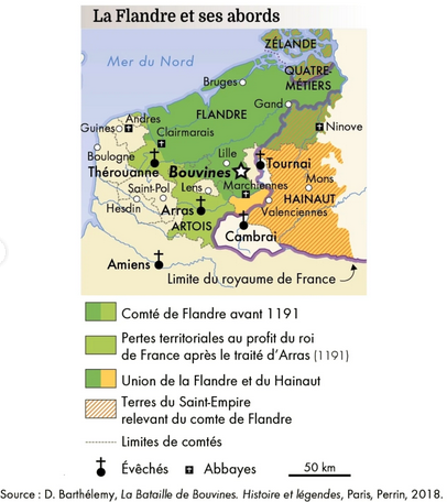
This map depicts the county of Flanders in the 12th century, providing a detailed representation of the geographical boundaries, urban centers, and significant features that characterized this influential region during the medieval period. Flanders, located in present-day Belgium and parts of northern France, was a vibrant hub of trade and culture. The map highlights major cities such as Bruges, Ghent, and Ypres, which played crucial roles in the economic and social life of the time, as well as the surrounding agricultural lands and waterways that supported its thriving communities.
Deep Dive into Flanders in the 12th Century
Flanders in the 12th century was a remarkable region marked by rapid economic growth and urbanization. This period is often considered the height of its medieval prosperity, largely due to its strategic location along trade routes connecting Northern Europe and the Mediterranean. The introduction of new agricultural techniques and the cultivation of flax for textiles, particularly linen, transformed the landscape into productive farmland. Interestingly, the region’s agriculture was complemented by a burgeoning textile industry that became a hallmark of Flanders’ economy.
The waterways depicted on the map, including the River Lys and the Bruges-Zeebrugge canal, were vital for transportation and trade. Merchants utilized these waterways to transport goods efficiently, connecting inland towns with the bustling ports. Have you ever wondered why Bruges became such an influential city? Its status as a major trading center, with an annual fair that attracted traders from across Europe, solidified its role in the economy. Moreover, the map illustrates a network of roads that facilitated overland trade, showcasing the region's comprehensive transport infrastructure.
Culturally, Flanders was a melting pot of influences. The wealth generated from trade led to the patronage of the arts, resulting in a flourishing of Gothic architecture and the emergence of notable art schools. The map captures not only the geographical but also the cultural landscape of the time, as cities like Ghent became known for their grand cathedrals and civic buildings, which were expressions of both wealth and communal pride.
Regional Analysis
When analyzing the map of Flanders, it's intriguing to observe the distinct characteristics of its various regions. For instance, the western part, around the coastal areas, was heavily influenced by maritime trade. Bruges, situated near the coast, became the heart of this commerce, while cities like Ypres and Dunkirk also benefited from their proximity to the sea. Conversely, the inland areas, particularly around Ghent, were more agrarian, focusing on agriculture and textile production.
Additionally, the map indicates the presence of fortified towns, essential for defense against invasions and rival claims. These fortifications, such as those around Bruges, played a significant role in the security of trade routes, ensuring the prosperity of the region. Each town had its unique identity shaped by its economic activities and cultural heritage. Interestingly, the competition among these towns often spurred innovation and development, giving rise to a dynamic and competitive environment.
Significance and Impact
Understanding the geography of Flanders in the 12th century is crucial for appreciating the broader historical context of medieval Europe. The region's economic model, centered around trade and industry, laid the foundation for the later development of capitalism in Europe. Today, Flanders remains a significant economic region, and its historical roots continue to influence its modern identity.
Moreover, the trends established during this period have implications that resonate even today. The shift from agrarian economies to trade-centric urban centers marked a pivotal change in societal structures, leading to the development of a merchant class and changing class dynamics. As we look at current trends in global trade and urbanization, the lessons from Flanders’ past offer valuable insights into how economies can evolve.
In conclusion, the map of Flanders in the 12th century not only illustrates the geographical features of the time but also serves as a window into the complex interplay of trade, culture, and defense that characterized this pivotal era in European history.
Visualization Details
- Published
- August 17, 2025
- Views
- 224
Comments
Loading comments...