Jihlava Iglau German Language Island Map 1934

Marcus Rodriguez
Historical Geography Expert
Marcus Rodriguez specializes in historical cartography and geographic data analysis. With a background in both history and geography, he brings unique...
Geographic Analysis
What This Map Shows
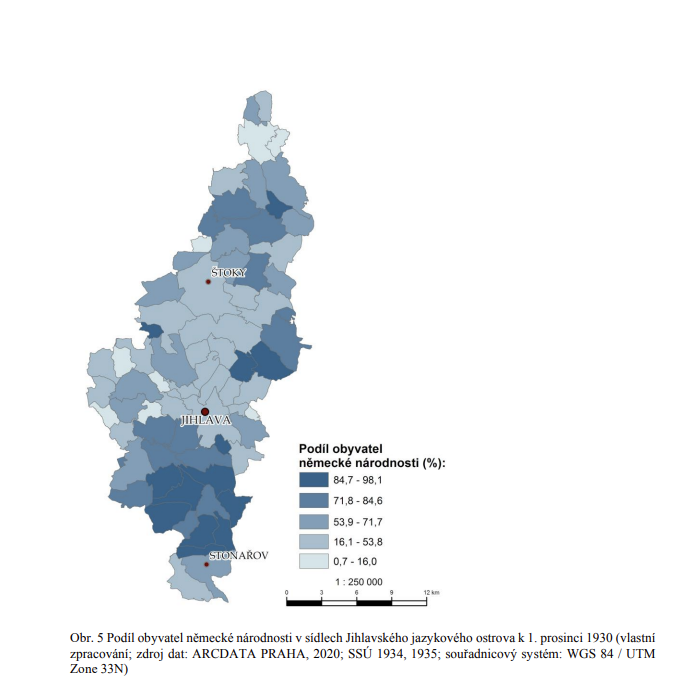
The map titled "Jihlava/Iglau German Language Island - Proportion of German Nationality in 1934/1935" presents a fascinating snapshot of the demographic landscape of Jihlava, a city in the Czech Republic that was known for its significant German-speaking population during the interwar period. The visualization highlights the proportion of individuals identifying as German nationals within the city, effectively illustrating the cultural and linguistic divides that existed in this region during the early 20th century. This map serves as a historical document that not only reflects the demographics of Jihlava but also offers insights into the broader historical context of the German minority in Czechoslovakia.
Deep Dive into the German Nationality in Jihlava
During the years leading up to World War II, the city of Jihlava, known as Iglau in German, was home to a substantial German-speaking population. This demographic phenomenon was largely the result of historical migrations and the geopolitical landscape of Central Europe. After the Austro-Hungarian Empire's dissolution post-World War I, the newly formed Czechoslovakia included a significant number of ethnic Germans, particularly in regions like Jihlava.
In 1934/1935, the proportion of German nationals in Jihlava was notably high, with estimates suggesting that Germans constituted approximately 40-50% of the population. This demographic dominance was not only a reflection of the population distribution but also of the cultural influences that shaped the city. German was the primary language in various spheres of daily life, including education, commerce, and local governance.
Interestingly, the presence of a German language island within a predominantly Czech environment highlights the complexities of national identity and cultural integration. The coexistence of Czechs and Germans in Jihlava is a testament to the region's multicultural heritage; however, it also foreshadowed tensions that would arise in the subsequent decades. The rise of nationalism in the 1930s led to increasing friction between these ethnic groups, with political movements advocating for the rights of ethnic Germans often clashing with the growing Czechoslovak national identity.
Statistical data from the time indicates that the German population in regions like Jihlava had significant social and economic roles. Many German nationals were engaged in industries such as textiles, brewing, and mining, which were vital to the local economy. The demographic trends observed in this city were not unique, as other areas in Bohemia and Moravia also showcased similar patterns of German settlement.
Regional Analysis
When we delve deeper into the demographics of Jihlava, it's essential to compare it with other areas in the Czech lands during the same period. For instance, cities like Brno and Plzeň also had notable German-speaking populations, though the proportions varied. Brno, for instance, had a slightly lower percentage of Germans overall, but certain districts were predominantly German-speaking.
In Jihlava, the map delineates specific neighborhoods where the German presence was most pronounced. These areas often had distinct cultural markers—such as German schools, churches, and social clubs—that served as focal points for the community. Interestingly, while the map shows a strong German presence, it also reflects the neighborhoods where Czechs predominantly resided, illustrating the demographic mosaic of the city.
The variations in German national proportions across these regions are key to understanding the broader national tensions. The stark contrasts between Jihlava and neighboring towns provide insight into how geographic proximity influenced social relations and interactions among ethnic groups.
Significance and Impact
Understanding the demographics of Jihlava in the 1930s is vital for comprehending the historical context leading up to World War II. The tensions between the German and Czech communities were not merely cultural; they were deeply intertwined with political and social movements that sought to redefine national identities in the face of external pressures. The map serves as a reminder of the intricate layers of identity and belonging that exist within a singular geographic space.
Moreover, this historical analysis is particularly relevant today as many regions in Central and Eastern Europe continue to navigate issues of ethnic diversity and integration. The lessons drawn from Jihlava’s past highlight the importance of dialogue and understanding among different cultural groups.
Looking to the future, one can ponder the implications of historical demographic shifts on contemporary society. How do past identities shape current social policies? What can we learn from the coexistence and conflicts of the past? These questions remain crucial as we reflect on the evolving narratives of identity in Central Europe.
In conclusion, the "Jihlava/Iglau German Language Island - Proportion of German Nationality in 1934/1935" map is not just a visual representation of demographics; it is a portal into a time and place where cultural identities shaped lives, communities, and histories.
Visualization Details
- Published
- August 13, 2025
- Views
- 110
Comments
Loading comments...