Map of the United States 1783 to 1803

Marcus Rodriguez
Historical Geography Expert
Marcus Rodriguez specializes in historical cartography and geographic data analysis. With a background in both history and geography, he brings unique...
Geographic Analysis
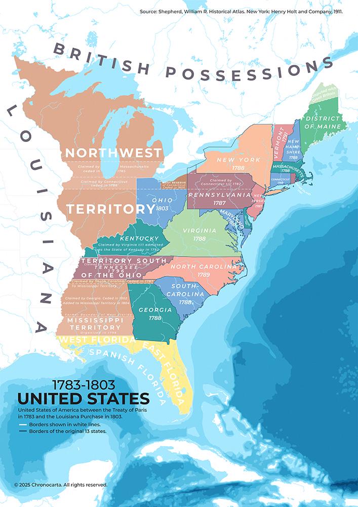
What This Map Shows
This map illustrates the territorial expansion of the United States from 1783 to 1803, a transformative period in American history. It highlights the boundaries established by the Treaty of Paris, which ended the Revolutionary War, and details the subsequent growth leading up to the monumental Louisiana Purchase. The map serves as a visual representation of the evolving political landscape of the early United States, showcasing both the original thirteen states and the vast territories that would soon be integrated into the young nation.
Deep Dive into Territorial Expansion
The period from 1783 to 1803 was crucial in shaping the territorial identity of the United States. Following the Treaty of Paris in 1783, the nation gained independence from British rule, which also marked the official recognition of its boundaries. At this time, the U.S. encompassed approximately 827,000 square miles, primarily along the Atlantic coast. The land was sparsely populated, with a majority of the citizens residing in the eastern seaboard states, such as Virginia, Massachusetts, and Pennsylvania.
However, what’s fascinating is the rapid expansion that followed. The Northwest Ordinance of 1787 established a framework for settling and governing the Northwest Territory, which included present-day Ohio, Indiana, Illinois, Michigan, and Wisconsin. This legislation not only paved the way for new states to join the Union but also encouraged migration westward, as settlers sought new opportunities and land.
In 1790, the U.S. population was about 4 million, and it grew steadily as people moved westward. The concept of Manifest Destiny—though not yet coined—began to take root in the American psyche. People believed it was their divine right to expand across the continent, setting the stage for future territorial acquisitions.
The next significant milestone occurred in 1803 with the Louisiana Purchase, where the United States acquired approximately 828,000 square miles of territory from France for $15 million. This purchase effectively doubled the size of the nation overnight, providing access to vast resources and lands stretching from the Mississippi River to the Rocky Mountains.
Regional Analysis
When analyzing the map, we can see distinct regions that illustrate the contrast in development and settlement patterns. The original thirteen states, primarily along the Atlantic coast, were well-established by 1783, benefiting from earlier European colonization. In contrast, the Northwest Territory was still largely uncharted and sparsely populated, with Native American tribes such as the Shawnee and Miami maintaining their traditional lands.
Interestingly, the cultural and economic dynamics shifted dramatically after the Louisiana Purchase. The newly acquired lands offered vast agricultural potential, particularly for cotton and grain production, which would later fuel the nation’s economy. The Southern states, such as Kentucky and Tennessee, began to expand their agricultural practices further west, leading to increased tensions over slavery as new territories entered the Union.
As the map illustrates, the population density was heavily skewed toward the East Coast, while the Midwest remained a frontier. By 1800, the population of Ohio was just over 45,000, a clear indication of the migration trends but still a small fraction compared to the eastern states, where cities like Philadelphia and New York were burgeoning.
Significance and Impact
Understanding the territorial evolution of the United States during this period is crucial not just for historical context, but also for recognizing how these changes set the stage for future conflicts and developments. The Louisiana Purchase, for instance, had significant implications for the nation’s economy, politics, and social fabric. It raised questions about the extension of slavery into new territories, a debate that would continue to escalate in the coming decades.
Moreover, the expansion westward brought about significant interactions—sometimes violent—with Native American tribes whose lands were encroached upon. The policy of Manifest Destiny not only illustrated a nationalistic fervor but also laid the groundwork for policies that would result in displacement and suffering for many indigenous populations.
In contemporary discussions, the implications of this expansion can be seen in various ways, from debates on land use to environmental concerns regarding agriculture and urban development. The legacy of this period remains relevant as we consider how past territorial decisions shape current national boundaries, demographics, and cultural identities.
Ultimately, this map is more than just a visual representation of land; it encapsulates a transformative era that defined the trajectory of the United States, setting the stage for its future as a continental power.
Visualization Details
- Published
- August 10, 2025
- Views
- 120
Comments
Loading comments...