
David Chen
Data Visualization Specialist
David Chen is an expert in transforming complex geographic datasets into compelling visual narratives. He combines his background in computer science ...
Geographic Analysis
What This Map Shows
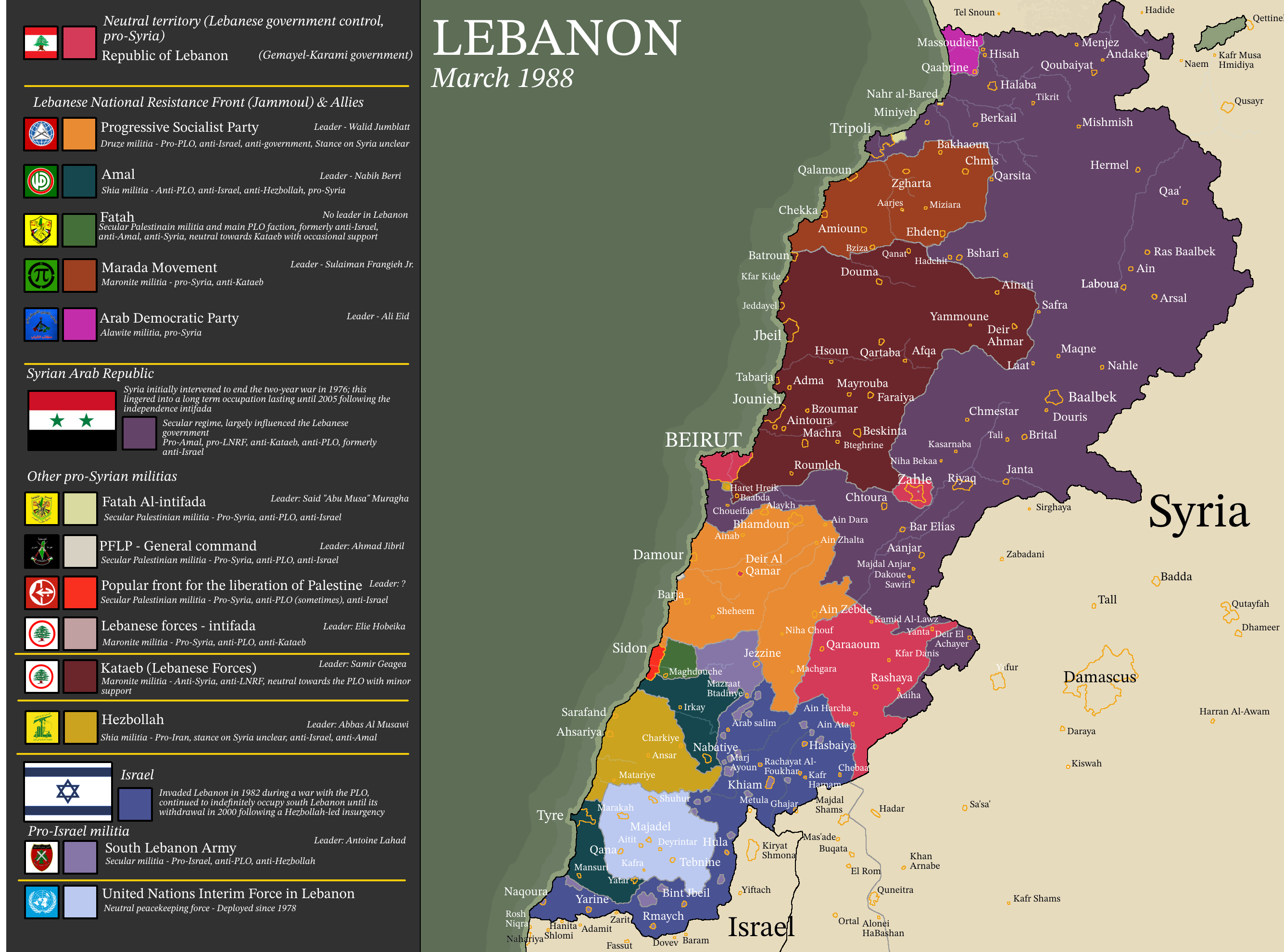
The 1988 map of Lebanon illustrates the complex and fractured political landscape that emerged during the Lebanese Civil War, which lasted from 1975 to 1990. This period was marked by significant territorial divisions as various factions established control over different regions, leading to the creation of cantons and statelets across the country. The visualization captures these divisions, showing how Lebanon was segmented into numerous areas, each dominated by different religious and political groups. The landscape of Lebanon in 1988 was not just a reflection of geographical boundaries; it was a vivid representation of the socio-political tensions that characterized this tumultuous period.
Deep Dive into Lebanon's Civil War Geography
The Lebanese Civil War was a multifaceted conflict fueled by a mix of sectarian divisions, foreign interventions, and socio-economic disparities. The map provides a clear visual representation of these divisions, which were largely influenced by Lebanon's diverse population, comprising various religious sects including Sunni Muslims, Shiite Muslims, Maronite Christians, and Druze, among others.
Interestingly, Lebanon's civil conflict can be traced back to the National Pact of 1943, which established a power-sharing agreement among the country's major religious groups. However, over the years, demographic shifts and political grievances led to increased tensions. By the late 1970s, these tensions exploded into violence, resulting in the establishment of multiple cantons that effectively fragmented the country.
In 1988, we can observe several key regions on the map: - **East Beirut**: Predominantly Christian, this area was controlled by the Lebanese Forces, a major Christian militia. - **West Beirut**: A mix of Sunni and Shiite population, this area saw control by various factions, including the PLO (Palestine Liberation Organization) and later Hezbollah. - **The Chouf Mountains**: This area was predominantly Druze and witnessed significant conflict between the Druze and Christian militias, leading to a distinct territorial division. - **South Lebanon**: Heavily influenced by Shiite communities, this area was often a battleground for different factions and later became a stronghold for Hezbollah.
The fragmentation depicted on the map was not merely geographical; it reflected deep-seated historical grievances and the struggle for power among these groups. By 1988, the map showcases a Lebanon that was not just divided by physical borders but also by ideological and sectarian lines, creating a patchwork of territories that were often at odds with one another.
Regional Analysis
When we break down the map by regions, the contrasts become even more pronounced. For instance, in the northern regions, including Tripoli and Akkar, the influence of Sunni factions was prevalent, while the central regions, particularly around Mount Lebanon, were predominantly Christian. This sectarian division created a stark contrast in governance and control, with each faction imposing its own laws and initiatives within its territory.
In the Beqaa Valley, we see a mix of Shiite and Christian populations, leading to a unique dynamic where both groups attempted to exert influence. The map’s depiction of these areas illustrates how different factions not only controlled territory but also affected the lives of thousands of civilians caught in the conflict. The impact of these divisions was profound, leading to widespread displacement and humanitarian crises as people fled from one section to another, often seeking safety from ongoing violence.
Significance and Impact
Understanding the geographical divisions of Lebanon in 1988 is crucial for comprehending the long-lasting impacts of the civil war, which have shaped contemporary Lebanon. The legacy of these divisions continues to influence the political landscape today, as sectarian identities remain strong and often lead to political gridlock. Ever wondered why Lebanon's political system seems so fragmented? The answer lies in the very cantons established during this civil war.
Moreover, the map serves as a reminder of the human cost of war. The displacement, loss of life, and destruction that occurred during the civil war are reflected in the map's divisions. As Lebanon continues to navigate its complex socio-political landscape, understanding this historical context is essential. Recent trends show a rise in sectarian tensions again, indicating that the lessons of the past are still relevant today. Looking toward the future, the hope is that Lebanon can move beyond its divided past and forge a more unified identity that transcends sectarian lines, but the road to reconciliation remains fraught with challenges.
In conclusion, the 1988 map of Lebanon is not just a historical artifact; it is a powerful reminder of the complexities of national identity, the consequences of civil strife, and the enduring impact of territorial divisions shaped by conflict.
Visualization Details
- Published
- August 9, 2025
- Views
- 142
Comments
Loading comments...