Map of the Caliphate of Qurtuba (Córdoba) at Its Greatest Extent

Marcus Rodriguez
Historical Geography Expert
Marcus Rodriguez specializes in historical cartography and geographic data analysis. With a background in both history and geography, he brings unique...
Geographic Analysis
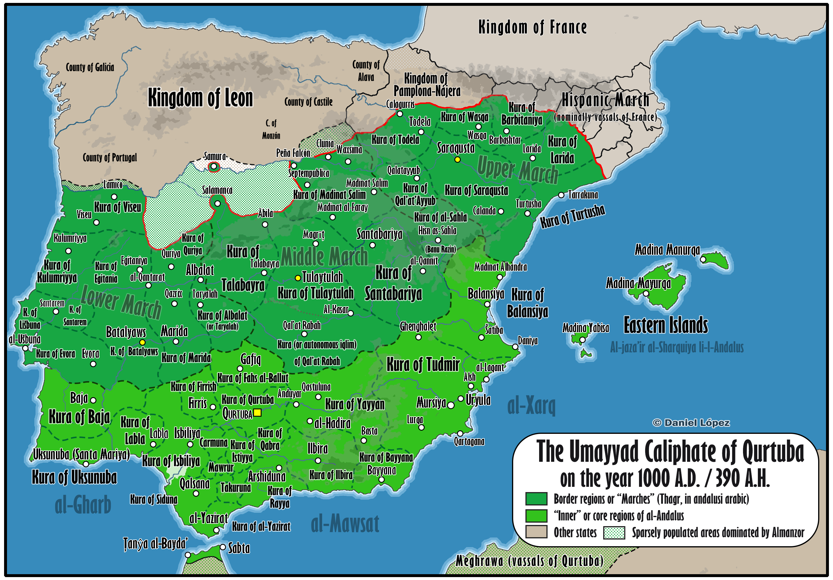
What This Map Shows\nThis detailed map illustrates the Caliphate of Qurtuba (Córdoba) at its peak under the rule of Almanzor, showcasing the vast territorial expanse that marked a significant period in medieval Iberian history. The map highlights not only the geographical boundaries of the caliphate but also the key cities, trade routes, and cultural hubs that were instrumental in shaping the socio-political landscape of the time. As we delve deeper into the historical context, it becomes clear that this was a period marked by remarkable achievements in governance, culture, and the sciences.
Deep Dive into the Caliphate of Qurtuba\nThe Caliphate of Qurtuba emerged in the 10th century as a prominent Islamic state in the Iberian Peninsula, representing a period of prosperity and cultural flourishing known as Al-Andalus. At its greatest extent, particularly during the reign of Almanzor (circa 978-1002 CE), the caliphate controlled a significant portion of the Iberian Peninsula, including modern-day Spain and Portugal. This era was characterized by advancements in various fields such as philosophy, science, architecture, and the arts, which were heavily influenced by the rich cultural tapestry of the region.
Interestingly, the caliphate served as a melting pot of cultures, where Muslims, Christians, and Jews coexisted, leading to an exchange of ideas and knowledge that would resonate throughout Europe for centuries. The city of Córdoba itself was a beacon of enlightenment, boasting one of the largest libraries in the world at the time and a university that attracted scholars from various backgrounds.
During Almanzor’s rule, military campaigns expanded the caliphate's borders significantly, with territories reaching as far north as present-day France. This military prowess not only secured the caliphate’s dominance but also facilitated trade routes that connected the Islamic world with Europe and beyond. The strategic positioning of Córdoba allowed for the flourishing of trade in goods such as silk, spices, and precious metals, making it an economic hub.
The architectural achievements from this period are still celebrated today. The Great Mosque of Córdoba, a stunning example of Islamic architecture, reflects the sophistication and artistic expression of the time. With its distinctive horseshoe arches and intricate tile work, it stands as a testament to the cultural significance of the caliphate.
Regional Analysis\nAnalyzing the map reveals how the territory of the Caliphate of Qurtuba was divided into various regions, each contributing uniquely to the overall prosperity of the caliphate. In the southern regions, cities such as Seville and Granada played crucial roles in commerce and cultural exchange. Seville, for instance, became a vital trade port, linking the caliphate with North Africa and the Mediterranean, while Granada emerged as a center for the arts and philosophy.
In contrast, the northern regions experienced different dynamics. The territories near the Christian kingdoms faced constant military pressure, leading to a complex interplay of conflict and diplomacy. The regions of León and Castile were particularly significant, as they represented the growing resistance against Islamic rule, which would eventually culminate in the Reconquista. This struggle for power created a diverse political landscape, with shifting allegiances and territorial claims.
The map also highlights the importance of the Guadalquivir River, which served as a lifeline for transportation and agriculture. The fertile lands along the riverbanks allowed for agricultural development, providing sustenance for the growing population and contributing to the economic strength of the caliphate.
Significance and Impact\nUnderstanding the extent of the Caliphate of Qurtuba under Almanzor is crucial for grasping the historical context of medieval Europe and the legacy of Islamic civilization. This period not only influenced the cultural and scientific advancements of the time but also laid the groundwork for future interactions between the Islamic and Christian worlds.
The intellectual exchanges that took place during this era had a lasting impact, particularly in fields such as mathematics, astronomy, and medicine, which would later fuel the European Renaissance. As we consider current trends in cultural exchange and globalization, it’s fascinating to reflect on how the interactions of the past continue to shape our contemporary world.
Moreover, the map serves as a reminder of the complexities of identity and coexistence in a multicultural society. As we navigate through an increasingly interconnected world, the lessons from the Caliphate of Qurtuba resonate with ongoing discussions about tolerance, diversity, and the importance of learning from different cultures.
In conclusion, this map not only delineates the geographical boundaries of a historical empire but also encapsulates a vibrant period of cultural synthesis that continues to inspire and inform our understanding of history today.
Visualization Details
- Published
- August 7, 2025
- Views
- 160
Comments
Loading comments...