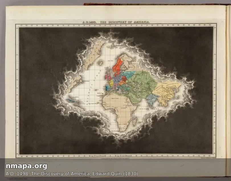
Map of America in A.D. 1498 by Edward Quin

David Chen
Data Visualization Specialist
David Chen is an expert in transforming complex geographic datasets into compelling visual narratives. He combines his background in computer science ...
Geographic Analysis
What This Map Shows
The map titled "A.D. 1498. The Discovery of America, Edward Quin (1830)" serves as a historical snapshot of the geographical understanding of the Americas at the turn of the 16th century. This visualization captures the territories and outlines recognized by European explorers following Christopher Columbus's voyages, particularly focusing on the Caribbean and parts of Central America. It showcases a world still largely unknown to Europeans, filled with potential and mystery, as well as the various indigenous populations and their territories.
Transitioning from the visualization, let's delve into the actual topic of interest: the geographical implications of the early European interactions with the Americas and the subsequent changes in cartographic representations.
Deep Dive into European Exploration and Mapping of the Americas
The year 1498 marks a pivotal moment in the history of geography, as it represents one of the first instances of a European's detailed map of the New World. After Columbus’s first voyage in 1492, which primarily focused on the islands of the Caribbean, the subsequent voyages led to greater awareness and exploration of the mainland. This period is characterized by a rapid expansion of geographical knowledge, which was fueled by the Age of Discovery.
Interestingly, maps such as Quin’s not only depict physical landscapes but also encapsulate the political and social dynamics of the time. For example, the map delineates the Spanish territories, which were expanding rapidly due to conquests and colonization. The Iberian nations—Spain and Portugal—were at the forefront, laying claim to vast areas based on the Treaty of Tordesillas in 1494, which divided the newly discovered lands between them. This treaty was crucial in shaping the geopolitical landscape of the New World, as it allowed the Spanish to dominate much of South America while the Portuguese focused on Brazil.
What’s fascinating is the way indigenous populations are represented—or often underrepresented—on these early maps. The map signals the presence of various native groups, yet it fails to provide the depth and detail of their cultures, societies, and territories, reflecting a European-centered worldview. Indigenous peoples, such as the Taino in the Caribbean and the Aztecs in Mexico, had complex societies that were often overlooked in favor of highlighting European claims.
Moreover, the mapping practices of this era laid the groundwork for future geographic explorations. As explorers ventured further into the continent, the need for more precise and detailed maps became evident. These early maps, while often inaccurate by modern standards, were essential for navigation and laid down the foundational knowledge that would be built upon by future cartographers.
Regional Analysis
Focusing on the regions depicted in Quin’s map, we can observe distinct contrasts in the geographical knowledge and representation of various areas. The Caribbean islands are marked clearly, reflecting the early European interest in these territories, primarily for trade and resource extraction. The islands of Hispaniola, Cuba, and Puerto Rico appear prominently, showcasing their strategic importance as bases for further exploration.
In contrast, the mainland of what is now Central America is depicted with less clarity and detail. Regions such as the Yucatán Peninsula are outlined, but the complexities of the Mayan civilization—its cities, trade networks, and cultural practices—are largely absent. This discrepancy highlights the ongoing challenge of representing indigenous territories and the consequences of European exploration, which often disregarded local knowledge and governance.
Interestingly, the map also hints at the varied physical geography of the Americas. The mountainous regions, such as the Andes, and the extensive river systems, including the Amazon and Mississippi, are essential features that would soon attract European interest due to their potential for resource extraction and agriculture.
Significance and Impact
Understanding the cartography of A.D. 1498 is crucial for grasping the broader implications of European exploration in the Americas. This period not only led to the exchange of goods, ideas, and cultures, known as the Columbian Exchange, but also initiated a series of events that would drastically alter the course of history for both the indigenous populations and European countries.
The impact of these early maps continues to resonate today as we reflect on past injustices and the legacies of colonialism. The representation of America on maps has evolved significantly, but the foundational knowledge derived from these early explorations remains a critical part of our geographical history. Furthermore, as we consider modern-day implications, discussions around land rights, cultural preservation, and historical accuracy in mapping are more relevant than ever.
As we look to the future, the significance of accurate and inclusive mapping practices cannot be overstated. Understanding the past through maps enables us to recognize the importance of diverse perspectives and the intricate relationships between geography and culture. Maps like Quin's serve not just as historical artifacts but as reminders of the complex narratives that shape our world today.
Visualization Details
- Published
- August 5, 2025
- Views
- 140
Comments
Loading comments...