Nearest Foreign Country to Every Point in the United States Map

David Chen
Data Visualization Specialist
David Chen is an expert in transforming complex geographic datasets into compelling visual narratives. He combines his background in computer science ...
Geographic Analysis
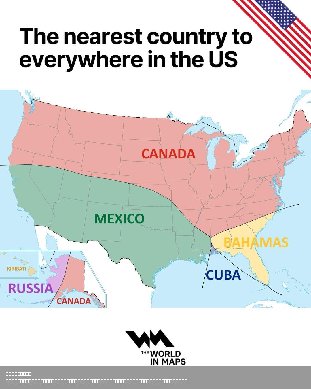
What This Map Shows
This map illustrates the nearest foreign country to every point in the United States, providing a compelling visual representation that highlights just how close the U.S. is to its neighbors. From Canada to Mexico and even parts of the Caribbean, this map reveals not only geographical proximity but also the intricate relationships between these nations. As we delve into this topic, it’s fascinating to consider how geographic boundaries shape not just maps, but also cultural and political dynamics.
Deep Dive into International Borders
The United States shares its land borders with two countries: Canada to the north and Mexico to the south. The U.S.-Canada border is the longest international border in the world, stretching over 5,525 miles. This extensive border runs from the Atlantic Ocean in the east to the Pacific Ocean in the west, incorporating diverse landscapes, from mountainous regions in the Rockies to the Great Lakes. Interestingly, the sheer length of the border means that many Americans live closer to Canada than they do to other parts of their own country.
On the flip side, the U.S.-Mexico border spans approximately 1,954 miles, running from the Pacific Ocean to the Gulf of Mexico. This border is not just a line on a map; it represents complex social, economic, and security issues. Areas like San Diego, California, and Tijuana, Mexico, are linked through a bustling cross-border culture, while other regions face challenges related to immigration and trade.
Have you ever wondered why certain areas within the U.S. are closer to foreign countries than others? The geography of the U.S. plays a significant role in this phenomenon. For example, Florida's proximity to Cuba means that the nearest foreign country for many residents is just a mere 90 miles away across the Straits of Florida. Similarly, the Aleutian Islands in Alaska stretch so far west that they are actually closer to Russia than to mainland Alaska. This unique geography creates fascinating scenarios, especially when considering cultural exchanges and geopolitical relationships.
Furthermore, it’s essential to recognize that the Caribbean islands, like the Bahamas and Cuba, are also among the nearest foreign territories for several coastal regions of the United States. This proximity fosters tourism, trade, and even environmental considerations, as these islands are on the front lines of climate change, impacting U.S. coastal policies and preparedness.
Regional Analysis
Diving deeper into regional specifics, we can analyze how different U.S. states interact with their nearest foreign countries. In the Northeast, states like Maine and New York are adjacent to Canada, with cities like Buffalo and Portland serving as major gateways for trade and travel. The cultural influences from Canada are palpable here, particularly in cuisine and festivals.
Moving southward, the relationship with Mexico is paramount for states like Texas and California. Cities such as El Paso and San Diego are not only economic hubs but also cultural melting pots where U.S. and Mexican traditions blend seamlessly. The impact of this relationship is evident in everything from local cuisine to community festivals that celebrate both cultures.
Interestingly, in the Great Lakes region, states like Michigan and Wisconsin share significant ties with Canada. The Great Lakes themselves are a vital resource for both countries, facilitating trade and providing essential water resources. This area showcases how geographical proximity can lead to collaborative environmental efforts, particularly in addressing issues like water quality and invasive species.
Significance and Impact
Understanding the nearest foreign country to every point in the United States is not just an academic exercise; it has real-world implications. The geographical positioning influences trade agreements, immigration policies, and even defense strategies. For instance, the U.S.-Mexico border has been a focal point in discussions about immigration reform and national security.
Moreover, as we face pressing global challenges like climate change, the relationships between the U.S. and its neighboring countries are more critical than ever. The effects of climate change, such as rising sea levels and extreme weather events, do not respect borders. Therefore, collaborative approaches to environmental sustainability and disaster preparedness are essential for the future of all nations involved.
In conclusion, this map serves as a reminder of the interconnectedness of geography, culture, and politics. The nearest foreign countries to the U.S. are not just neighbors on a map; they are integral to understanding the broader implications of geography in our daily lives. As we move forward, it’s vital to consider these relationships in discussions about policy, culture, and environmental stewardship.
Visualization Details
- Published
- August 5, 2025
- Views
- 110
Comments
Loading comments...