Map of al-Andalus' Upper March and Subdivisions, c.950

Marcus Rodriguez
Historical Geography Expert
Marcus Rodriguez specializes in historical cartography and geographic data analysis. With a background in both history and geography, he brings unique...
Geographic Analysis
What This Map Shows
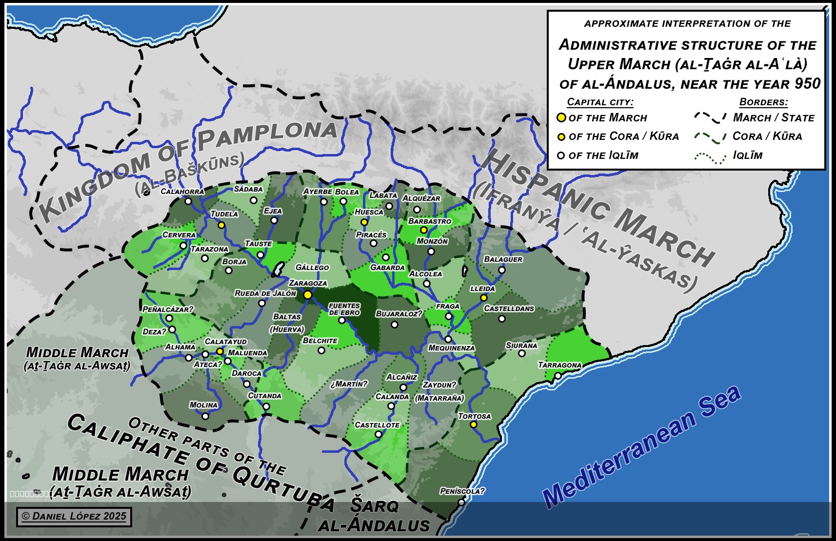
This map titled "Map of al-Andalus' Upper March and its subdivisions, c.950" provides an insightful snapshot of the political and administrative landscape of the Upper March during the peak of the Umayyad Caliphate in Iberia. The map delineates the various Kūwar (provinces) and their subdivisions known as Aqalīm (districts), showcasing the intricate governance structure of this remarkable historical period. Each province and district is marked, with some areas still shrouded in mystery, indicated by question marks. This uncertainty highlights the challenges historians face when piecing together the past, especially in regions steeped in a rich tapestry of cultural and political change.
Deep Dive into the Administrative Structure of al-Andalus
The administrative organization in al-Andalus was complex and pivotal in managing the diverse populations within its borders. The term "Kūra" refers to a province, serving as a significant administrative unit under the Caliphate. Each Kūra was further divided into Aqalīm, which functioned as districts. This hierarchical structure was essential for maintaining control over the vast territories of al-Andalus, which was characterized by a mosaic of ethnicities, languages, and cultures.
Interestingly, al-Andalus was not just a center for Islamic scholarship and culture; it also played a crucial role in trade networks that connected Europe, North Africa, and the Middle East. The provinces and districts were strategically located along vital trade routes, facilitating economic prosperity and cultural exchange. For instance, the province of Córdoba emerged as a major cultural and political hub, boasting advancements in science, philosophy, and the arts.
What’s fascinating is the extent to which the geography of al-Andalus influenced its administrative divisions. The mountainous regions, fertile plains, and river valleys dictated settlement patterns and agricultural practices, impacting how provinces were organized. For example, the regions around the Guadalquivir River were particularly fertile, leading to a concentration of agricultural activity and, consequently, a more significant population density compared to the arid areas to the east.
The historical context of the map reveals that the Upper March was a frontier region marked by both conflict and cultural exchange. The Christian kingdoms to the north exerted pressure on the Muslim territories, leading to a dynamic interplay of military, social, and economic factors. This constant state of flux necessitated a responsive administrative structure, adapting to both opportunities and challenges as they arose.
Regional Analysis
Delving deeper into the various provinces depicted on the map, we can observe distinct characteristics that set them apart. For instance, the Kūra of Toledo was known for its strategic military importance and served as a cultural melting pot, attracting scholars and artists from across the Muslim world and beyond. Its role as an administrative center was paramount, making it a focal point for the distribution of resources and governance.
Conversely, areas marked with a “?” suggest regions where historical records are scant. These ambiguities often leave gaps in our understanding of local governance and culture. The Kūra of Mérida, for example, while historically significant, suffers from limited documentation, making it difficult to ascertain the precise nature of its administrative centers and subdivisions. This lack of clarity invites speculation and further research, emphasizing the importance of archaeological and historical studies in reconstructing the past.
In contrast, the province of Granada emerged later as a prominent center of culture and learning, showcasing the evolution of administrative significance over time. By the late 10th century, it was becoming increasingly important as a center for the Muslim populace in the south, illustrating how regions within al-Andalus were not static but rather evolved based on political, social, and economic changes.
Significance and Impact
Understanding the administrative landscape of al-Andalus is crucial not only for comprehending its historical context but also for recognizing its lasting impact on modern Spanish culture and politics. The intricate governance structures established during this time laid the groundwork for future administrative divisions in Spain, influencing how regions are organized today.
Moreover, the cultural exchanges that occurred within these provinces contributed significantly to the European Renaissance. The preservation and translation of classical texts, facilitated by scholars in cities like Córdoba and Toledo, played a vital role in the intellectual revival of Europe.
Today, as we study this map and the historical significance of the Upper March, we uncover layers of cultural heritage that continue to shape identities in contemporary Spain. The dialogues between Muslim, Christian, and Jewish communities during this period laid the foundation for a multicultural society that remains relevant in discussions about identity and coexistence in modern contexts. As we reflect on the past, it's vital to appreciate the complexities of governance and culture that have influenced our world today.
Visualization Details
- Published
- August 4, 2025
- Views
- 92
Comments
Loading comments...