1876 Historical Map of Bolivian Highlands and Lake Titicaca

Alex Cartwright
Senior Cartographer & GIS Specialist
Alex Cartwright is a renowned cartographer and geographic information systems specialist with over 15 years of experience in spatial analysis and data...
Geographic Analysis
What This Map Shows
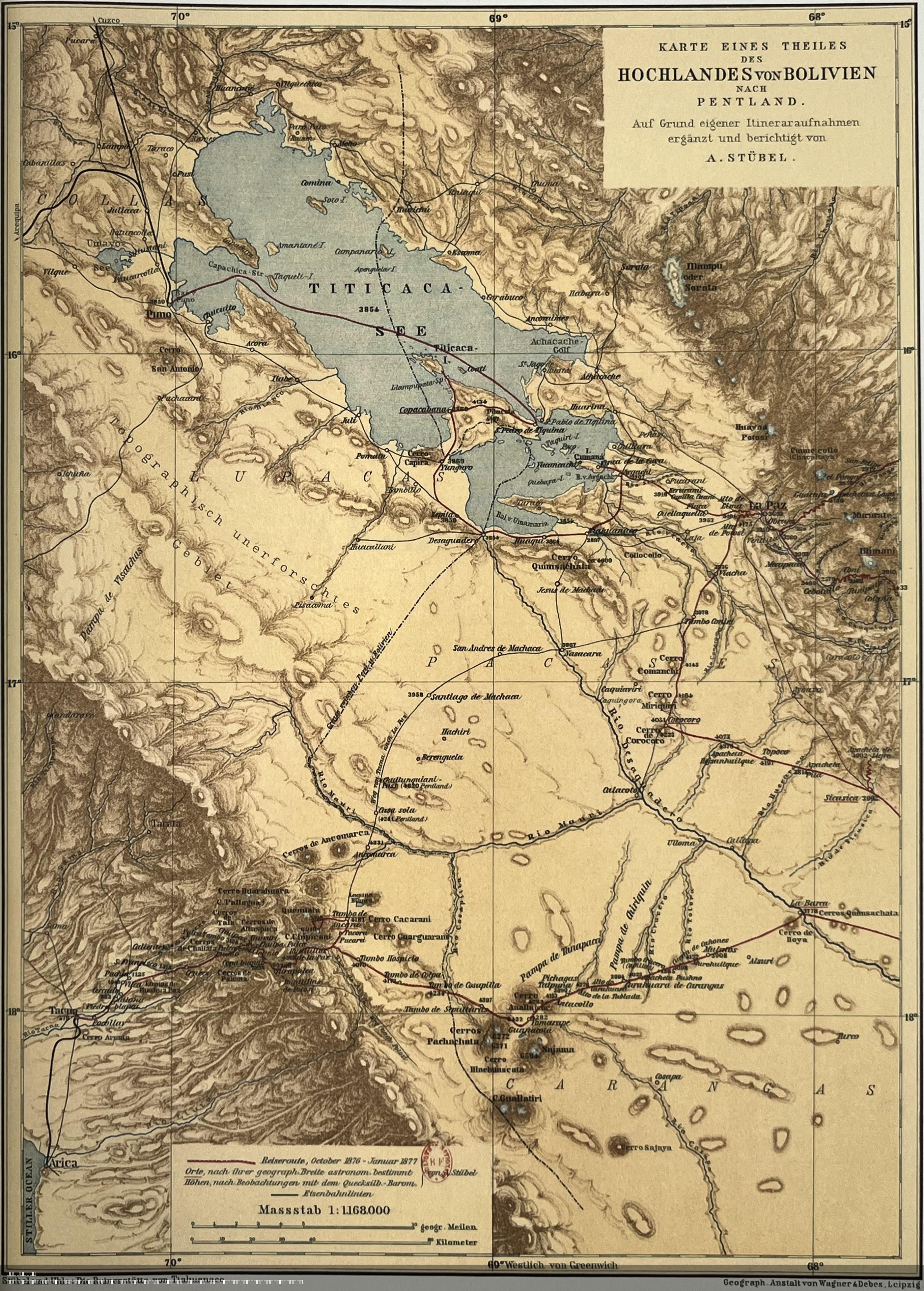
The 'German Historical Map of the Bolivian Highlands and Lake Titicaca Region (circa 1876–1877)' provides a detailed representation of a significant geographical area of South America. This map not only illustrates the topographical features of the Bolivian Highlands and the expansive Lake Titicaca but also serves as a historical snapshot, revealing how these landscapes were understood in the late 19th century. The cartography highlights various elevations, water bodies, and the proximity of indigenous settlements, offering insights into the socio-economic and cultural aspects of the region at that time.
Transitioning from the visual representation, let’s delve deeper into the unique geography and historical significance of Lake Titicaca and the surrounding highlands.
Deep Dive into the Bolivian Highlands and Lake Titicaca
Lake Titicaca, straddling the border between Bolivia and Peru, is renowned as the highest navigable lake in the world, sitting at an elevation of approximately 3,812 meters (12,507 feet) above sea level. The lake spans about 8,372 square kilometers (3,232 square miles) and reaches depths of up to 281 meters (922 feet). What’s fascinating is its significance not just as a water body but also as a cultural and historical landmark for indigenous peoples, particularly the Aymara and Quechua, who have lived in the region for thousands of years.
The Bolivian Highlands are characterized by their rugged terrain, comprising of steep mountains and vast plateaus. This geography has shaped the way of life for the local populations, influencing agricultural practices and settlement patterns. The region's climate is primarily cool and dry, with distinct wet and dry seasons, which impacts crop yields and biodiversity.
Interestingly, the Bolivian Highlands are home to various ecosystems. The altiplano (high plain) supports hardy crops such as quinoa and potatoes, while the lake itself is rich in aquatic life, including the endemic Titicaca water frog. The region also serves as a crucial watershed, feeding rivers that are vital for agriculture and domestic use.
In terms of historical context, the late 19th century was a period of significant change for the Bolivian Highlands. The industrial revolution was influencing global trade, and Bolivia was looking to capitalize on its mineral wealth, particularly tin and silver mining. The map from this era reflects not only the physical geography but also the burgeoning infrastructure, including roads and railways, that were being developed to access these resources.
Regional Analysis
Exploring the map further, we can see distinct regions within the Bolivian Highlands, each with unique characteristics. For example, the area around the city of La Paz, which sits at an altitude of about 3,650 meters (11,975 feet), serves as both a political and economic hub. The geography here is marked by steep valleys and mountain ridges, influencing urban planning and development.
In contrast, the southern region near Potosí, known for its rich mineral deposits, demonstrates a different economic focus. The historical significance of Potosí is immense; once one of the richest cities in the world due to its silver mines, the area’s geography played a crucial role in its economic development, leading to a boom in population and wealth.
Furthermore, the northern shores of Lake Titicaca, particularly around Copacabana, have a more tourism-driven economy today, drawing visitors to its natural beauty and cultural heritage. The region is known for its stunning landscapes and vibrant festivals, reflecting the rich traditions of the indigenous peoples.
Significance and Impact
Understanding the geography of the Bolivian Highlands and Lake Titicaca is crucial not only for historical context but also for contemporary issues. Climate change poses threats to high-altitude ecosystems, and shifts in weather patterns are affecting traditional agricultural practices. Additionally, the region is increasingly impacted by tourism, which, while beneficial economically, raises concerns about environmental sustainability and cultural preservation.
Today, as we see a growing focus on sustainable practices, the historical insights provided by maps like this one from 1876–1877 can guide current and future development. They remind us of the importance of balancing economic growth with ecological preservation and cultural respect. Have you ever noticed how historical maps can shed light on modern challenges? It’s a reminder that geography is not just about locations; it’s about the stories and struggles of the people connected to those places.
In conclusion, the German Historical Map of the Bolivian Highlands and Lake Titicaca Region serves as a vital educational tool, offering a glimpse into the past while informing current geographical and cultural dynamics. Understanding this map's content helps us appreciate the intricate tapestry of life that exists in this remarkable part of the world.
Visualization Details
- Published
- August 4, 2025
- Views
- 110
Comments
Loading comments...