Currently Erupting Volcano Map Near You

Marcus Rodriguez
Historical Geography Expert
Marcus Rodriguez specializes in historical cartography and geographic data analysis. With a background in both history and geography, he brings unique...
Geographic Analysis
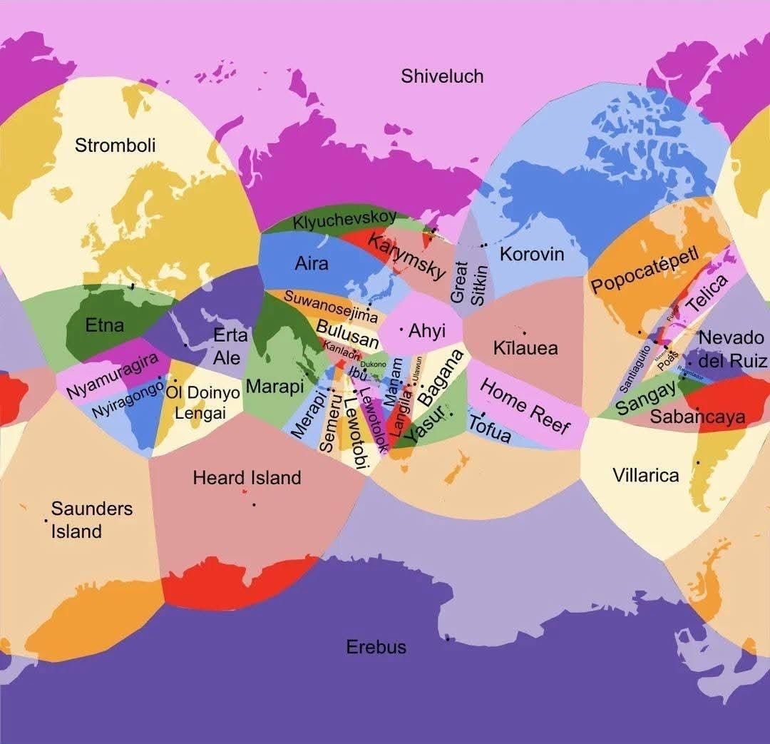
What This Map Shows\nThis map provides a real-time overview of currently erupting volcanoes across the globe and indicates their proximity to various locations. Each volcano is marked, allowing you to quickly identify which one is nearest to you. This information is crucial, especially for those living in volcanic regions or planning to travel to areas near active volcanoes.
Deep Dive into Volcanoes\nVolcanoes are fascinating geological formations that present both beauty and danger. They are openings in the Earth’s crust through which molten rock, ash, and gases escape from below the surface. The study of volcanoes, known as volcanology, reveals much about the Earth's internal processes and can help predict potential eruptions. According to the United States Geological Survey (USGS), there are approximately 1,500 active volcanoes worldwide, with about 500 of those erupting in recorded history.
What's particularly interesting is that volcanic eruptions vary significantly in size and impact. Some eruptions can be quite small, producing little more than a puff of smoke, while others can unleash devastating lava flows that alter landscapes and affect air travel across continents. The eruption of Mount St. Helens in 1980, for example, was a significant event that provided a wealth of information regarding volcanic activity and its consequences.
There are different types of volcanoes, including shield, stratovolcano, and cinder cone, each with unique eruption styles and characteristics. Shield volcanoes, like Kilauea in Hawaii, are known for their broad, gentle slopes and relatively non-explosive eruptions. In contrast, stratovolcanoes, such as Mount Fuji in Japan, are characterized by steep profiles and explosive eruptions that can produce significant ash clouds. Cinder cone volcanoes are the simplest type, often formed from small eruptions that create cone-shaped hills.
Understanding volcanoes is crucial not just for academic reasons but also for safety and preparedness. For instance, the proximity of a volcano can have direct implications for local populations. Areas located near active volcanoes must have emergency plans in place for evacuation and disaster response. Interestingly, some regions even thrive due to their volcanic soil, which is rich in nutrients and supports agriculture.
Regional Analysis\nWhen examining the map of currently erupting volcanoes, specific regions stand out. For instance, the Pacific Ring of Fire is home to a significant number of the world's active volcanoes. This area, which encircles the Pacific Ocean, is particularly prone to seismic activity due to tectonic plate movements. Countries such as Indonesia, Japan, and the Philippines experience frequent eruptions, making it essential for residents to stay informed about volcanic activity.
In contrast, Europe has a different volcanic landscape. Italy, with its famous Mount Vesuvius and Mount Etna, frequently witnesses eruptions that attract tourists but also pose risks to nearby communities. Interestingly, Mount Etna is one of the most active volcanoes in the world and erupts regularly, providing a unique opportunity for scientists to study volcanic activity up close.
North America, particularly the United States, also has several active volcanoes, including those in Alaska and Hawaii. The Kilauea volcano, which has been erupting continuously since 1983, is a prime example of how active lava flows can reshape the landscape and provide insight into volcanic behavior. The 2018 eruption of Kilauea led to significant changes in the island's geography and was a stark reminder of the power of nature.
Significance and Impact\nUnderstanding the locations of currently erupting volcanoes is not just an academic exercise; it has real-world implications. As climate change continues to impact weather patterns and seismic activity, the potential for volcanic eruptions may also evolve. Communities near active volcanoes need to remain vigilant, as eruptions can lead to evacuations, loss of property, and, in some cases, loss of life.
Moreover, the volcanic ash produced during eruptions can have far-reaching effects on air quality and global temperatures. For instance, the eruption of Mount Pinatubo in 1991 released an enormous amount of ash and sulfur dioxide into the atmosphere, which led to a temporary cooling of the Earth's climate.
In conclusion, this map serves as a powerful tool for visualizing volcanic activity and understanding the geographical implications of living near these natural wonders. By staying informed and prepared, we can better mitigate the risks associated with these majestic yet volatile formations. So, next time you glance at a map of erupting volcanoes, consider how close you might be to one and what it means for your safety and the environment.
Visualization Details
- Published
- October 26, 2025
- Views
- 6
Comments
Loading comments...