Current Frontline in Eastern Ukraine Map

Alex Cartwright
Senior Cartographer & GIS Specialist
Alex Cartwright is a renowned cartographer and geographic information systems specialist with over 15 years of experience in spatial analysis and data...
Geographic Analysis
What This Map Shows
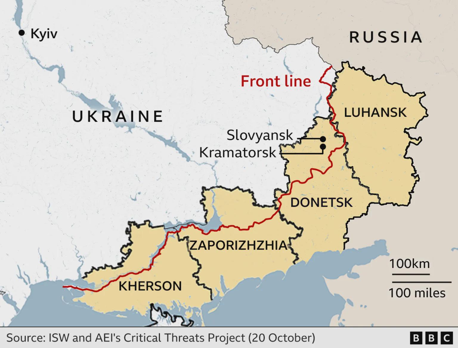
The visualization titled "Current Frontline in Eastern Ukraine: Proposed Ceasefire Boundary Between Russian and Ukrainian Forces" provides a critical snapshot of the ongoing conflict in Eastern Ukraine. This map outlines the proposed ceasefire boundaries, indicating the areas currently held by Russian forces as opposed to Ukrainian forces. Understanding the geographical context of this frontline is essential for grasping not only the military dynamics but also the humanitarian implications of the conflict.
Transitioning from the visual representation, let's delve deeper into the geopolitics and military geography of Eastern Ukraine, specifically focusing on the frontline areas and their significance.
Deep Dive into the Frontline Dynamics
The frontline in Eastern Ukraine is not just a mere line on a map; it represents a complex interplay of military strategy, ethnic divisions, and historical grievances. The region has seen significant transformation since the conflict began in 2014, with various ceasefires attempted but largely failing to hold. The proposed boundary represents a potential shift in the conflict dynamics, highlighting areas where both sides may agree to de-escalate military engagement.
Interestingly, the frontline cuts through key urban and industrial areas, notably around cities like Donetsk and Luhansk, which are vital for both economic and strategic reasons. The Donbas region, encompassing these cities, has been historically significant for Ukraine, rich in coal and manufacturing resources. Control over this area is not just about territorial gain; it’s about securing economic viability for both Ukrainian and separatist forces.
Statistics reveal that the conflict has led to severe humanitarian crises, with over 14,000 people reported dead and millions displaced. The frontline map helps visualize these human costs, showcasing how communities have been divided and lives disrupted. Have you ever wondered why certain towns become flashpoints in conflicts? In Eastern Ukraine, the reasons are often tied to historical ties, ethnic composition, and economic resources.
Moreover, the geographical features of the region, including rivers and hills, play a crucial role in military operations. For example, the Siverskyi Donets River serves as both a natural barrier and a strategic resource, influencing troop movements and supply lines. The rugged terrain has been advantageous for defensive positions, complicating offensive operations on both sides.
Regional Analysis
Examining the map closely, we can see variations in territorial control. In the north, areas like Luhansk are predominantly under separatist control, whereas cities further south, like Mariupol, have remained under Ukrainian government influence. This disparity raises questions about the local population's sentiments. What’s fascinating is that surveys suggest that opinions on the conflict can vary dramatically even within small geographic areas, influenced by local leadership, historical ties, and economic conditions.
The proposed ceasefire boundary reflects these divisions. For instance, while some regions show a willingness to negotiate peace, others remain staunchly opposed, often due to the influence of external political actors. The delineation of control on the map is not static; it changes frequently with military engagements, and this variability illustrates the fragile nature of peace in the region.
Significance and Impact
Why does understanding the proposed ceasefire boundary matter? The implications stretch far beyond military strategy; they encompass humanitarian considerations, international relations, and regional stability. The ongoing conflict has implications for global security, affecting relations between NATO, the EU, and Russia. The proposed boundaries could serve as a starting point for negotiations, but they also highlight the entrenched positions that complicate peace efforts.
Furthermore, the humanitarian aspect cannot be overlooked. Access to aid, the resettlement of displaced populations, and the restoration of basic services hinge on the success of any proposed ceasefire. Interestingly, the map serves as both a tool for military planners and a stark reminder of the human cost of war.
Looking forward, there’s a cautious optimism that continued dialogue can lead to more stable boundaries. However, history shows that such optimism must be tempered with realism. The evolving situation in Eastern Ukraine remains a key area of focus for geopolitical analysts and humanitarian organizations alike.
In conclusion, the frontline map of Eastern Ukraine is more than just a geographical representation; it encapsulates the struggles, hopes, and complexities of a region at the heart of a significant geopolitical conflict. Understanding this map helps us grasp the broader implications of the situation, both locally and globally.
Visualization Details
- Published
- October 22, 2025
- Views
- 8
Comments
Loading comments...