Settlements in the New World, 1650 Map

Marcus Rodriguez
Historical Geography Expert
Marcus Rodriguez specializes in historical cartography and geographic data analysis. With a background in both history and geography, he brings unique...
Geographic Analysis
What This Map Shows
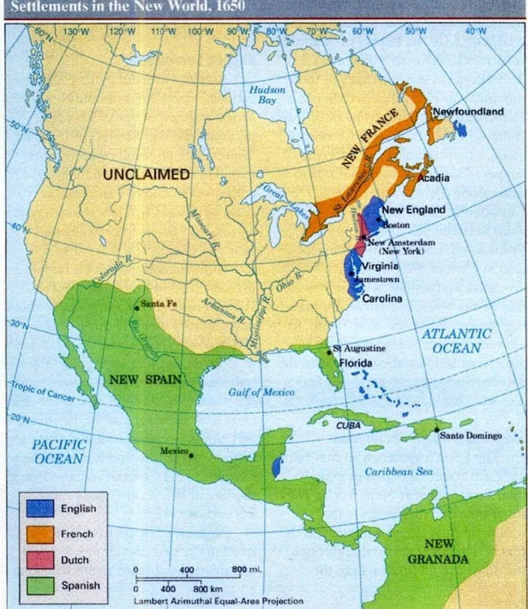
The "Settlements in the New World, 1650 Map" provides a visual representation of the various European colonial settlements established across North America, South America, and the Caribbean during the mid-17th century. It highlights the locations of key settlements, the extent of territorial claims, and the geographical features that influenced their establishment. This map not only marks the locations of these settlements but also serves as a historical snapshot of European expansion, trade routes, and interactions with Indigenous populations.
Deep Dive into Colonial Settlements
In 1650, the New World was a patchwork of emerging European colonies, each influenced by its own national interests, economic ambitions, and social structures. The primary European powers involved in this exploration and settlement included Spain, France, England, and the Netherlands. Each nation brought distinct approaches to colonization, which, in turn, shaped the development of the settlements.
Spanish settlements, particularly in present-day Mexico, Florida, and the southwestern United States, were primarily driven by the search for gold, silver, and other resources. Cities like Mexico City (formerly Tenochtitlán) and St. Augustine were not just military outposts but also centers of cultural and religious missions. Interestingly, the Spanish established a vast network of missions aimed at converting Indigenous peoples, which played a significant role in the cultural dynamics of the region.
In contrast, English settlements, particularly along the Atlantic coast, were often established for agricultural purposes and religious freedom. The Jamestown settlement, founded in 1607, marked the beginning of a significant English presence in North America. By 1650, the Virginia colony had expanded significantly, laying the groundwork for tobacco as a cash crop that would define the economy of the southern colonies. The Puritan settlements in New England, on the other hand, were established by groups seeking religious autonomy, leading to the development of communities that valued education and governance based on religious principles.
French settlements, located primarily in Canada and along the Mississippi River, focused on fur trading and alliances with Indigenous tribes. Quebec, established in 1608, became a crucial hub for the fur trade, and the French's relatively cooperative relationships with Indigenous nations contrasted sharply with the often confrontational approaches taken by the English and Spanish.
Moreover, the Dutch settlements in what is now New York were initially focused on trade and commerce, particularly in fur. New Amsterdam, the capital of the New Netherland colony, was a bustling port that attracted a diverse population, including many from different European countries.
Regional Analysis
When analyzing the map regionally, it becomes evident that the motivations behind settlement varied widely. In the Caribbean, for instance, the sugar plantation economy led to a focus on large-scale agriculture, primarily involving enslaved Africans. Islands such as Barbados became centers of sugar production, which would later lead to significant demographic and economic shifts.
In North America, the English settlements along the eastern seaboard were marked by a mix of agricultural and trade-based economies. The southern colonies, particularly Virginia and the Carolinas, leaned heavily on plantation agriculture, while the northern colonies, including Massachusetts and New Hampshire, developed more diversified economies that included fishing, shipbuilding, and trade.
The Spanish settlements in the southwest were significantly influenced by their established presence in Central and South America, which allowed them to project power and influence across the region. The missions and presidios established were often situated in locations that facilitated control over trade routes and resources.
Interestingly, while the map highlights the European settlements, it also indirectly illustrates the displacement and transformation experienced by Indigenous populations. The interactions between European settlers and Indigenous peoples varied, from trade alliances to violent confrontations, which would have long-lasting effects on the demographic landscape of the New World.
Significance and Impact
Understanding the settlements of the New World in 1650 is crucial for grasping the historical context of European colonization and its repercussions. These early settlements laid the groundwork for the future development of nations, including the United States and Canada, shaping cultural identities and economic systems that persist to this day.
Furthermore, the implications of these colonial endeavors are still felt today. Issues surrounding land rights, cultural preservation, and the legacies of colonialism remain pertinent. The map serves as a reminder of how the past continues to influence the present, particularly in discussions about Indigenous rights and recognition.
As we reflect on this map, have you ever wondered how the settlement patterns established in the 17th century continue to affect modern geopolitical landscapes? The lessons learned from this era of exploration and colonization are critical in understanding current global dynamics and the ongoing impacts of historical events on contemporary societies.
Visualization Details
- Published
- October 18, 2025
- Views
- 32
Comments
Loading comments...