Tang China 700 CE Map During Empress Wu Zetian

Alex Cartwright
Senior Cartographer & GIS Specialist
Alex Cartwright is a renowned cartographer and geographic information systems specialist with over 15 years of experience in spatial analysis and data...
Geographic Analysis
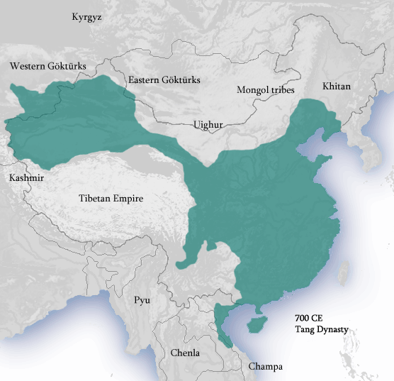
What This Map Shows
This map presents an overview of Tang China in the year 700 CE, specifically during the reign of the formidable Empress Wu Zetian. It highlights not only the political boundaries of the Tang dynasty but also the major cities, trade routes, and significant geographical features that defined this period in Chinese history. The Tang dynasty, known for its cultural and economic prosperity, was at its zenith during this time, making this map a vital source for understanding the geographical context of its achievements.
Deep Dive into Tang China in 700 CE
At the heart of Tang China was its impressive administrative structure and vibrant society, supported by a robust geographical framework. The Tang dynasty, stretching from the eastern coast to the Central Asian steppes, was characterized by diverse landscapes including mountains, rivers, and fertile plains. One of the most significant geographical features of this era was the Yellow River, often referred to as the cradle of Chinese civilization. It not only provided essential irrigation for agriculture but also served as a crucial trade route that facilitated commerce and communication.
Interestingly, during Wu Zetian's reign, the Tang dynasty expanded its influence through trade and diplomacy along the Silk Road. This ancient network of trade routes connected the East with the West, allowing for an exchange of goods, ideas, and cultures. The bustling city of Chang'an, now modern-day Xi'an, was the dynasty's capital and a melting pot of different cultures and ethnicities, reflecting the cosmopolitan nature of Tang society. It was here that merchants from Persia, India, and beyond would converge, contributing to a vibrant marketplace and cultural exchange.
The Tang dynasty was also known for its innovations in agriculture, which were heavily influenced by the geography of the region. The introduction of new agricultural techniques, such as the use of early-ripening rice from Southeast Asia, allowed for increased food production, supporting the growing population. This surge in agricultural output led to urbanization, with cities expanding as people flocked to urban centers for trade and employment.
Moreover, the strategic location of the Tang dynasty meant that it was often at the crossroads of various cultural and political influences. The presence of the Tibetan Plateau to the west and the deserts of Central Asia to the north created both opportunities and challenges. The empire had to navigate relationships with nomadic tribes as well as neighboring states, which shaped its foreign policy and military strategy.
Regional Analysis
The map of Tang China reveals significant regional variations in geography and demographics. For instance, the eastern provinces, such as Shandong and Jiangsu, were considerably more fertile and densely populated compared to the arid regions of the northwest. The abundance of rice paddies in the south contrasted sharply with the dry, mountainous terrains of the north, where pastoralism was more common.
In the southern regions, cities like Hangzhou flourished due to their strategic locations along the waterways, enhancing trade and commerce. In contrast, the northern territories faced more significant challenges due to harsher climatic conditions and less fertile land. This disparity influenced not only economic activities but also cultural exchanges, with the south often seen as a center for arts and literature during this period.
Additionally, the map highlights the importance of the Grand Canal, which connected the Yellow River and Yangtze River systems. This engineering marvel facilitated the movement of goods and resources between northern and southern China, further integrating the empire's economy. The different regions varied in their contributions to the overall prosperity of the Tang dynasty, with urban centers in the east driving commerce while the western regions provided military strength and resources.
Significance and Impact
Understanding the geographical landscape of Tang China in 700 CE during Empress Wu Zetian's reign is crucial for several reasons. It offers insights into how geography influenced political power, social structures, and economic systems. The map serves as a reminder of the importance of geographic considerations in shaping historical narratives.
Today, the legacy of the Tang dynasty is still felt in modern China and beyond. Its cultural and economic achievements laid the foundation for subsequent dynasties and continue to influence Chinese identity. Current trends in regional development and urbanization often echo the patterns established during this golden age, emphasizing the ongoing relevance of geography in understanding historical and contemporary issues.
In conclusion, this map not only serves as a visual representation of Tang China but also invites a deeper exploration of the geographical factors that shaped one of history's most remarkable empires. By analyzing this map, we gain a clearer picture of how geography and human activity intersect to create the complex tapestry of civilization.
Visualization Details
- Published
- October 17, 2025
- Views
- 22
Comments
Loading comments...