Japan during Azuchi-Momoyama Period Map

Marcus Rodriguez
Historical Geography Expert
Marcus Rodriguez specializes in historical cartography and geographic data analysis. With a background in both history and geography, he brings unique...
Geographic Analysis
What This Map Shows
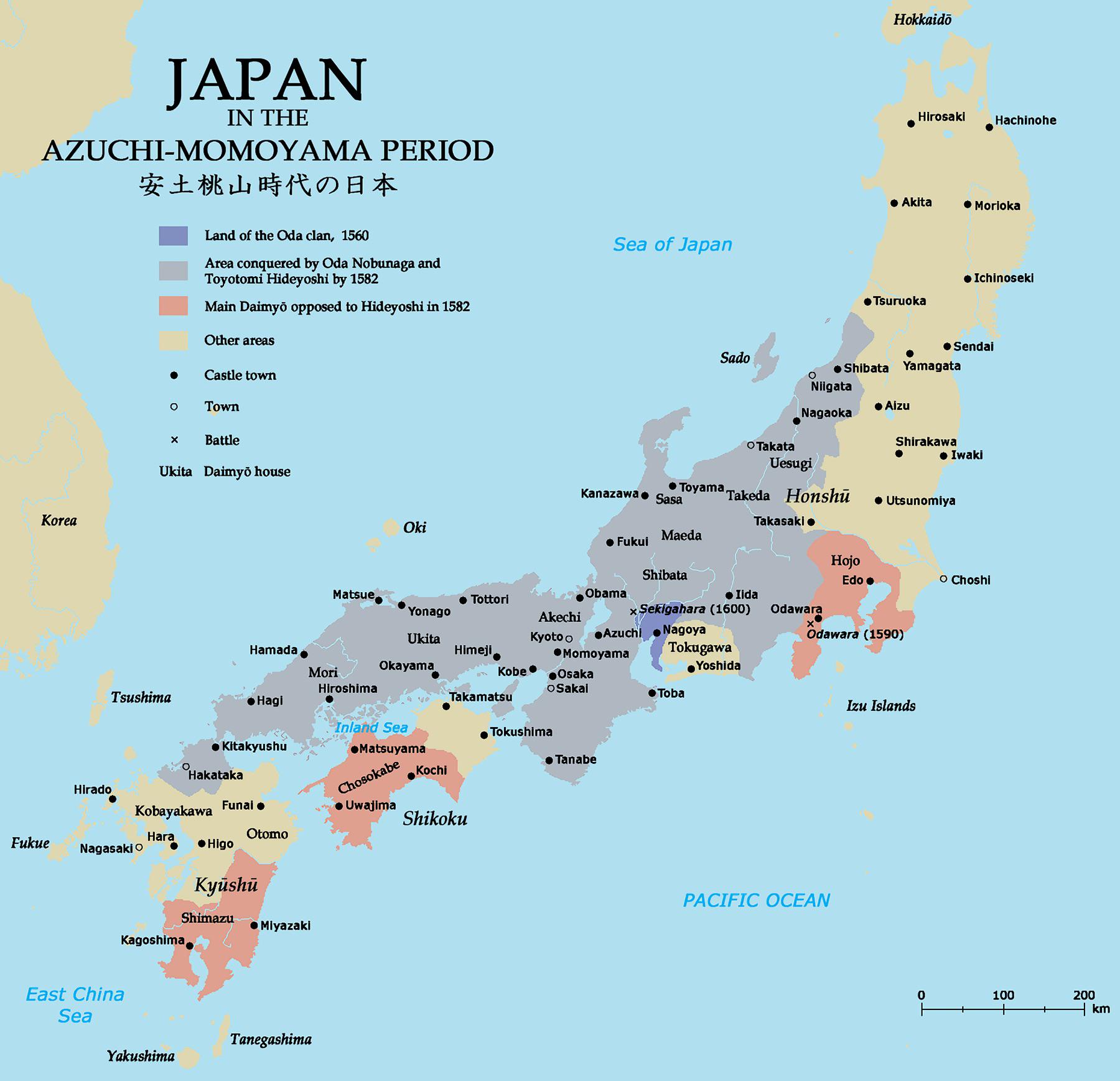
The map titled "Japan during Azuchi-Momoyama Period" provides a visual representation of the political and cultural landscape of Japan between the late 16th and early 17th centuries. This was a pivotal time marked by the unification of Japan under powerful warlords and the flourishing of arts and culture. The map highlights key cities, regions, and historical landmarks relevant to this transformative era, allowing us to understand the geographical context of the Azuchi-Momoyama period.
Deep Dive into the Azuchi-Momoyama Period
The Azuchi-Momoyama period, which roughly spans from 1568 to 1600, is often recognized as the bridge between Japan's feudal era and the eventual establishment of the Tokugawa shogunate. This period is characterized by significant political upheaval, marked by the rise of prominent figures such as Oda Nobunaga and Toyotomi Hideyoshi, who played crucial roles in consolidating power and unifying the nation.
One of the most fascinating aspects of this period is the emergence of castle towns, which were strategic urban centers that served as both military strongholds and administrative hubs. The map illustrates the locations of notable castles such as Azuchi Castle, built by Nobunaga, and Osaka Castle, which was later expanded by Hideyoshi. These fortifications were not just military installations; they became symbols of power and prestige, influencing local economies and cultures.
Interestingly, the period also witnessed a cultural renaissance. The arts flourished, with advancements in tea ceremonies, Noh theater, and the development of the iconic Japanese garden. The geographical layout of Japan played a vital role in these cultural exchanges, as trade routes opened up, connecting various regions. Kyoto, the imperial capital, became a cultural epicenter, while coastal cities engaged in trade with European countries, introducing new ideas and goods.
The demographic shifts during this time were also notable. As cities grew rapidly, the population began to urbanize, contributing to the emergence of a merchant class. This shift is reflected in the map's depiction of population centers. Have you ever wondered how these urban developments influenced local economies? The growth of commerce and trade led to increased wealth and a rise in the standard of living for many, although it also widened the gap between classes.
Regional Analysis
When examining the map in detail, we can see that different regions of Japan experienced varying levels of development during the Azuchi-Momoyama period. For instance, the Kansai region, particularly around Kyoto and Osaka, became a hub for political power and cultural activity. The proximity to fertile agricultural lands also meant that these areas could support larger populations.
In contrast, regions like Tohoku and Hokkaido were less developed during this time, primarily due to their geographical remoteness and harsh climates. The map highlights these disparities, showcasing how geographical factors influenced the pace of development. For example, while Kansai thrived as a center of commerce, many northern regions remained primarily agrarian, with limited access to trade networks.
Interestingly, the Chūgoku region emerged as a significant area for military logistics due to its strategic position. The map indicates key routes used by armies, revealing how geography facilitated or impeded military campaigns. The geographical features, such as mountains and rivers, were crucial in determining the success of various military strategies employed during the period.
Significance and Impact
Understanding the geography of Japan during the Azuchi-Momoyama period is vital for several reasons. Firstly, it provides insights into how geographical factors influenced political decisions and cultural developments. The interplay between geography and power dynamics shaped the future of Japan, leading to the eventual establishment of the Tokugawa shogunate and a prolonged period of peace known as the Edo period.
Moreover, the map serves as a reminder of the historical significance of urbanization and trade in shaping modern Japan. As cities expanded and economies diversified, the societal structure began to evolve, setting the stage for contemporary Japan's economic landscape. Today, we can see the remnants of this rich history in Japan's urban centers, which still reflect the cultural and political legacies of the Azuchi-Momoyama period.
In conclusion, the Azuchi-Momoyama period was a transformative time in Japanese history, and the geographical context illustrated by the map is crucial for understanding its complexities. As we reflect on this era, it's essential to recognize how geography continues to shape nations and cultures around the world, influencing everything from trade to urban development. What future trends might emerge from our current geographical realities? Only time will tell.
Visualization Details
- Published
- October 15, 2025
- Views
- 30
Comments
Loading comments...