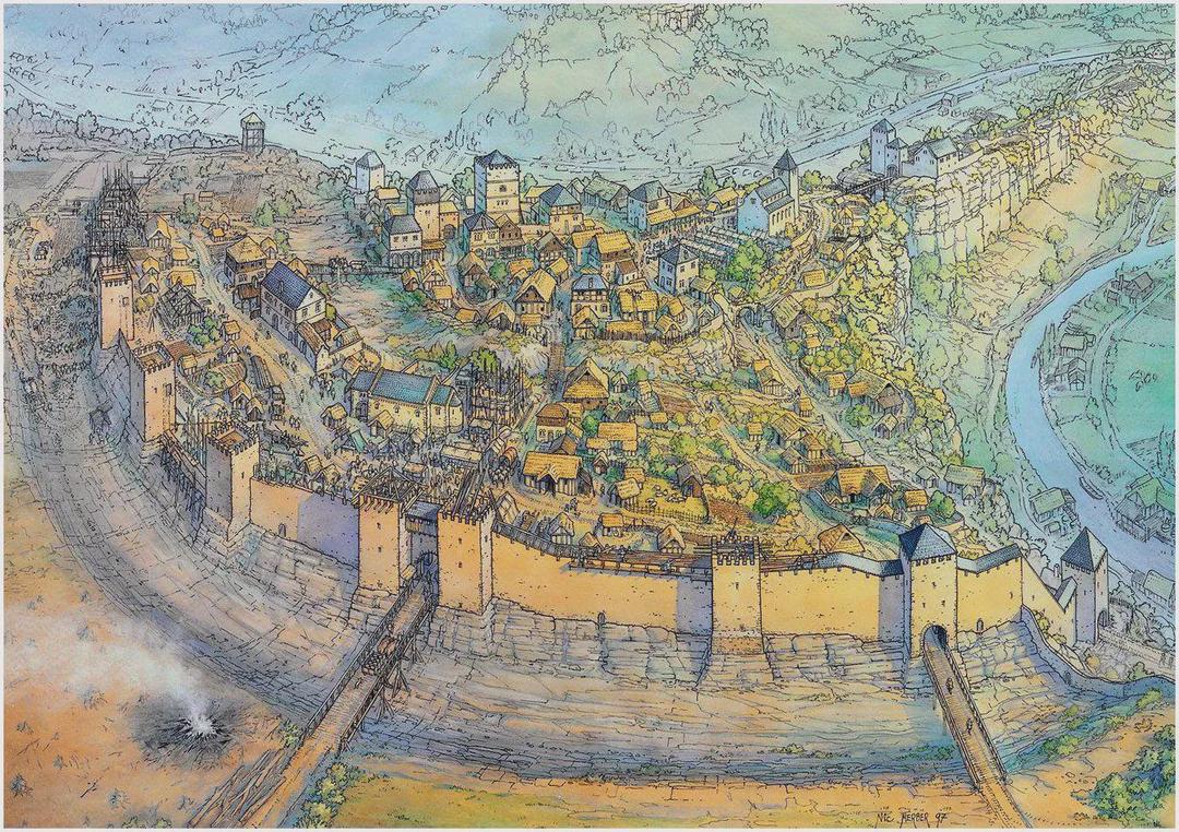
Map of Luxembourg in the 13th Century

David Chen
Data Visualization Specialist
David Chen is an expert in transforming complex geographic datasets into compelling visual narratives. He combines his background in computer science ...
Geographic Analysis
What This Map Shows
This map vividly illustrates the town of Luxembourg as it existed in the 13th century, a period characterized by significant political and social changes in Europe. The visualization highlights key landmarks, fortifications, and the geographical layout of the town, showcasing the strategic importance of Luxembourg during this era. It is set against the backdrop of the medieval landscape, replete with castles, trade routes, and natural barriers that shaped the development of the region.
Deep Dive into Luxembourg's 13th Century Landscape
The town of Luxembourg, established in the early 10th century, gained prominence by the 13th century as a vital political and military hub. Interestingly, its location at the confluence of the Alzette and Pétrusse rivers made it a natural fortress, offering both strategic advantages and challenges. The rocky cliffs surrounding the town provided a defensive barrier against potential invaders, while the rivers facilitated trade and movement. This duality of geography played a crucial role in the town's development.
During this century, Luxembourg was under the rule of the House of Luxembourg, a powerful dynasty that expanded its influence across Europe. This period saw the construction of significant fortifications, including the famous Bock Casemates, which were used to house soldiers and protect the town from sieges. These underground tunnels and chambers displayed advanced engineering for their time and reflected the military strategies employed by the rulers.
The population of Luxembourg during the 13th century was relatively small, but it was diverse, composed of various ethnic groups, including the local Luxembourgish, French, and German settlers. This diversity contributed to a rich cultural tapestry, influencing language, trade practices, and social structures. Additionally, the town became a melting pot of ideas as merchants and travelers passed through, bringing with them various customs and innovations.
Trade routes were critical to Luxembourg's economy, fostering connections with neighboring regions. The town served as a commercial crossroads, and its markets thrived with goods flowing from the Rhine Valley and beyond. The combination of local agriculture and imported goods allowed for a vibrant economy, essential for sustaining the town’s growth and stability.
Regional Analysis
When examining the map of Luxembourg in the 13th century, one can identify distinct regions that contributed to the town's economy and defense. The northern area, characterized by its steep hills and rocky terrain, was primarily residential and military in nature, while the southern area included fertile plains ideal for agriculture. This division allowed for a degree of specialization, with some areas focusing on farming and others on trade and military endeavors.
Interestingly, the trade routes emanating from Luxembourg connected to major cities like Trier and Metz, highlighting the town's role as a regional hub. The proximity to these larger urban centers provided Luxembourg with both challenges and opportunities. For instance, while larger cities could overshadow Luxembourg in terms of political power and wealth, they also offered lucrative trade opportunities that benefited the town's economy.
In contrast, the rural outskirts of Luxembourg were sparsely populated but vital for agricultural production. The agricultural practices of the time were relatively rudimentary compared to modern standards, but they sufficed for sustaining the local populace. The reliance on seasonal crops and livestock created a dependency on the surrounding environment, which was both a blessing and a challenge in times of drought or famine.
Significance and Impact
Understanding the geographical layout and historical context of Luxembourg in the 13th century is crucial for grasping the town's evolution into a prominent European center. The strategic location, fortified defenses, and economic opportunities laid the groundwork for Luxembourg's future as a capital and a symbol of national identity.
The implications of this historical geography extend to contemporary discussions about urban planning and heritage preservation. As cities today grapple with the challenges of modernization, the lessons learned from Luxembourg's medieval past can inform current strategies for sustainable development. Moreover, Luxembourg's transformation from a fortress town to a thriving capital underscores the dynamic nature of urban environments, where history and modernity coexist.
In conclusion, the map of Luxembourg in the 13th century is not merely a representation of land and structures; it tells a story of resilience, adaptation, and growth. Have you ever considered how the geographical features of a place can shape its history? As we reflect on such maps, we gain insights into the complex tapestry of human civilization, reminding us that geography is more than just a backdrop—it's a fundamental part of our shared narrative.
Visualization Details
- Published
- October 10, 2025
- Views
- 6
Comments
Loading comments...