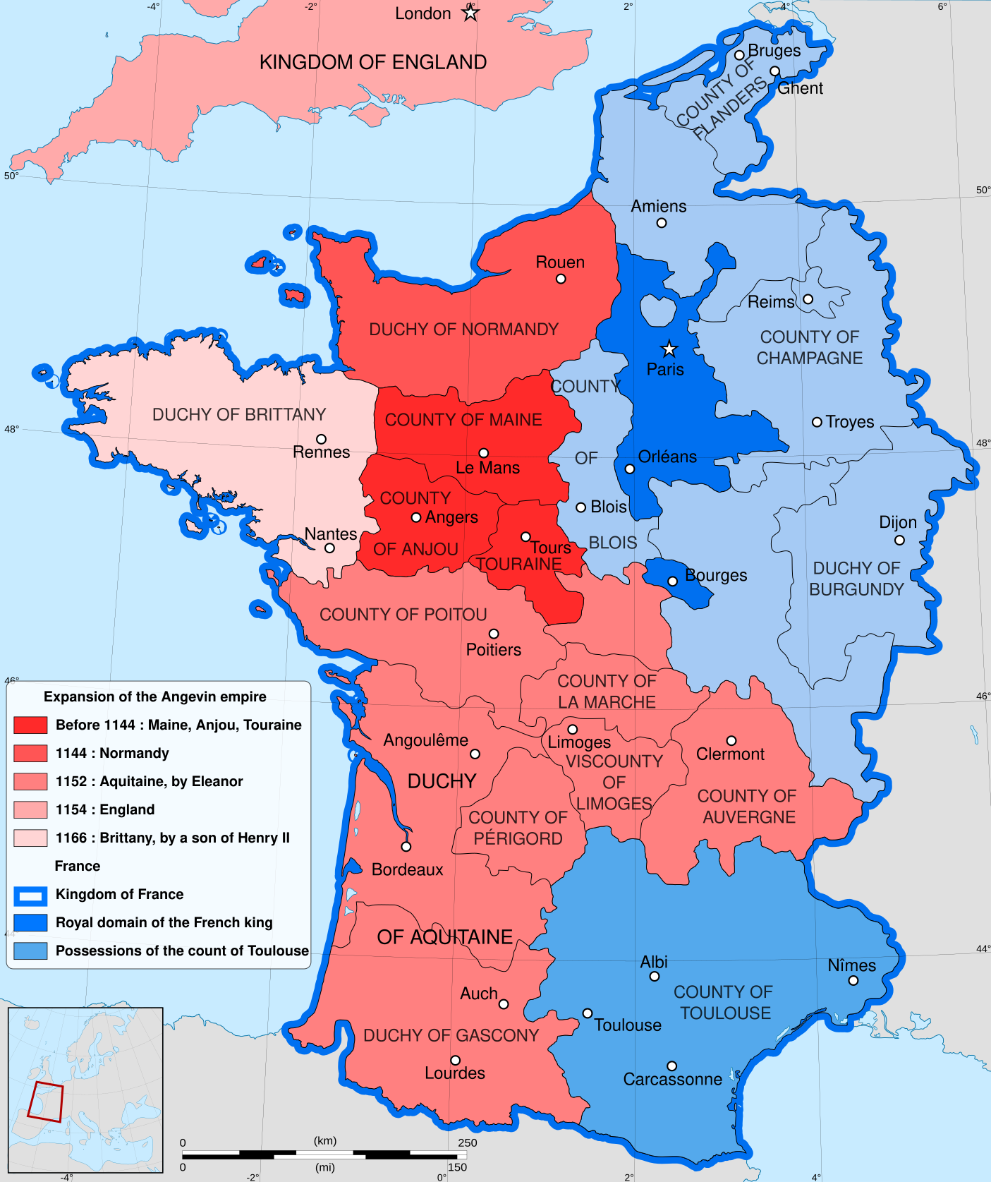
Map of English Possessions in France 1166

Alex Cartwright
Senior Cartographer & GIS Specialist
Alex Cartwright is a renowned cartographer and geographic information systems specialist with over 15 years of experience in spatial analysis and data...
Geographic Analysis
What This Map Shows
The visualization titled "English Possessions in France in 1166" provides a detailed look at the territories controlled by King Henry II of England during the height of the Plantagenet or Angevin Empire. In this year, the English monarch ruled over a significant portion of what we now know as France, although these lands were not officially part of the English crown as we understand it today. Instead, they were fiefs held by the king, showcasing a complex feudal relationship that defined the medieval landscape of Western Europe.
This map is particularly interesting because it illustrates the geographical spread of English influence outside of the British Isles at a time when dynastic ties, territorial claims, and feudal allegiances were paramount. The territories represented in this visualization included key provinces like Normandy, Anjou, Maine, and Aquitaine, all of which played crucial roles in the political dynamics of the era.
Deep Dive into the Plantagenet Empire
The Plantagenet Empire was a remarkable feat of medieval governance and territorial control. By 1166, King Henry II had consolidated power over vast lands that extended beyond England, essentially creating a patchwork of territories that were intertwined through familial ties and vassal obligations. This unique arrangement allowed for a diverse range of cultures, languages, and governance styles to coexist under one ruler.
One of the most significant aspects of the Plantagenet holdings was their strategic importance. Territories like Normandy were not just economically valuable; they were also crucial for military defense and control over trade routes. Interestingly, the English crown's hold on Normandy began with William the Conqueror in 1066, and by 1166, Henry II had re-established this connection, reinforcing the significance of this region in both English and French history.
Aquitaine, another key territory on the map, was particularly noted for its wealth and influence. This region was rich in agricultural production and viticulture, which contributed significantly to the economy of the Plantagenet Empire. The acquisition of Aquitaine also highlighted the shifting power dynamics between England and France during this period, as it was a substantial prize that came with its own set of local governance challenges.
The map also underscores the complexity of feudal relationships. While Henry II ruled over these lands, he was not an absolute monarch in the modern sense. His rule depended heavily on the loyalty of local lords and vassals, who were granted land in exchange for military service and allegiance. This decentralized power structure often led to conflicts, both internal and external, as local lords sometimes acted independently, challenging the king's authority.
Regional Analysis
When examining the specific regions shown in the map, it's essential to note the diversity in governance and culture. For instance, Normandy was characterized by a strong military tradition and was often the first line of defense against incursions from the French crown. The nobility in this region was deeply intertwined with the English royal family, which created unique cultural exchanges.
In contrast, the Aquitaine region had a more diverse population, including Occitan speakers and various local customs that were distinct from those in the north. The governance here was complicated by the presence of powerful local lords, such as the Duke of Aquitaine, who often had their own ambitions and agendas that could conflict with royal interests. This regional variation is a fascinating aspect of the Plantagenet Empire, illustrating how local contexts shaped the broader empire's dynamics.
Significance and Impact
The significance of the English possessions in France during 1166 cannot be overstated. This period marked a critical moment in the development of both English and French national identities. The territorial claims and conflicts of this era laid the groundwork for future confrontations, including the Hundred Years' War, which further defined the relationship between England and France.
What’s fascinating is how these historical ties still resonate today. The cultural and political legacies of the Plantagenet Empire can be seen in modern English and French relations, as well as in the ongoing discussions about regional identities within both countries. As we explore historical maps like this one, we gain a deeper understanding of the intricate tapestry of power, culture, and identity that has shaped Europe over the centuries.
In conclusion, the map of English possessions in France in 1166 serves as a window into a complex historical narrative, illustrating not just the geography of the time but also the intertwined fates of nations that continue to influence our world today.
Visualization Details
- Published
- October 4, 2025
- Views
- 44
Comments
Loading comments...