Land Cover Map of Ukraine

Marcus Rodriguez
Historical Geography Expert
Marcus Rodriguez specializes in historical cartography and geographic data analysis. With a background in both history and geography, he brings unique...
Geographic Analysis
What This Map Shows
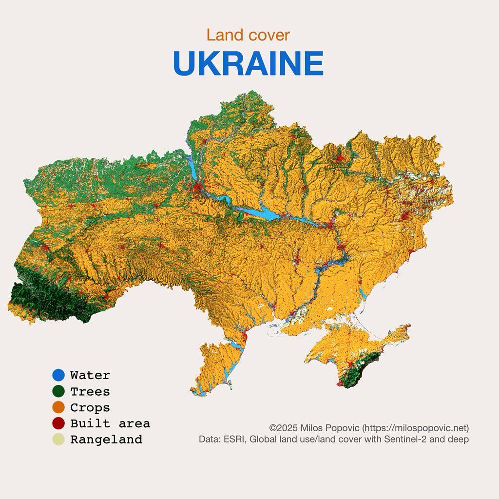
The "Land Cover of Ukraine" map provides a comprehensive overview of the various types of land cover across the country. This visualization categorizes land into different types such as forests, agricultural land, urban areas, and wetlands. Understanding land cover is essential for various applications including environmental management, urban planning, and agriculture. Now let's delve into how these land cover types interact with each other and the environment.
Deep Dive into Land Cover in Ukraine
Ukraine's land cover is diverse, reflecting its varied geography and climate. The country is predominantly characterized by agricultural land, which makes up approximately 57% of its total area. This high percentage is not surprising, given Ukraine's rich, fertile soil, particularly the chernozem, known for its dark color and high organic matter content. Often referred to as the "breadbasket of Europe," Ukraine is one of the world's largest grain producers, cultivating crops like wheat, barley, and corn.
Forests cover around 15% of Ukraine's territory, primarily found in the northern and western regions. These forests are home to a variety of flora and fauna, playing a crucial role in maintaining biodiversity. Notably, the Carpathian Mountains in the west host some of the most extensive forested areas, where beech and fir trees dominate. Interestingly, these forested regions are not only significant for wildlife habitat but also contribute to carbon sequestration, helping combat climate change.
Urban areas account for about 3% of land cover, with the most densely populated regions found in cities like Kyiv, Kharkiv, and Odesa. The urban landscape is constantly evolving, with ongoing developments influenced by economic growth and migration patterns. Have you noticed how urban sprawl can impact surrounding agricultural lands? In Ukraine, this is a growing concern as cities expand and encroach on fertile lands.
Wetlands, though covering a smaller portion of the land, are vital ecosystems. They support a diverse range of wildlife and provide essential services such as water filtration and flood control. The Danube Delta, a UNESCO World Heritage site, is one of the most significant wetlands in the country, hosting unique biodiversity and critical habitats for migratory birds.
Regional Analysis
When examining the land cover by region, differences become apparent. For instance, the southern regions, like the Mykolaiv and Odesa oblasts, are heavily agricultural, with vast fields of sunflowers and grain. In contrast, the northern regions, such as Chernihiv and Sumy, feature more forest cover and less agricultural land. Interestingly, this variation can be attributed to differences in soil quality, climate, and historical land use practices.
The western part of Ukraine, particularly the Ivano-Frankivsk and Lviv oblasts, is characterized by a mix of forests and agricultural land. The mountainous terrain here presents unique challenges for farming, yet the region is known for its dairy and livestock production. The central regions, including Kyiv and Cherkasy, blend urban areas with agricultural land, showcasing a transitional landscape that reflects both urban development and agricultural heritage.
Significance and Impact
Understanding Ukraine's land cover is crucial for several reasons. First, it informs land management practices that can enhance agricultural productivity while preserving natural ecosystems. As climate change continues to affect weather patterns, analyzing land cover can help predict how agricultural zones might shift, impacting food production and security.
Moreover, land cover data is vital for environmental conservation efforts. As urban areas expand, the pressure on agricultural and natural lands increases, leading to habitat loss and fragmentation. This map serves as a tool for policymakers to make informed decisions that balance development needs with environmental conservation.
In recent years, there has been a growing trend towards sustainable practices, such as organic farming and reforestation efforts in Ukraine. These initiatives not only aim to protect the environment but also promote economic resilience and community well-being. What's fascinating is how land cover plays a pivotal role in shaping these sustainable practices. By monitoring land use changes, stakeholders can better assess the effectiveness of their efforts and adjust strategies accordingly.
In conclusion, the land cover of Ukraine is not merely a representation of geographical features; it tells a story of the country's agricultural practices, urbanization trends, and ecological significance. As we continue to navigate the complexities of land management, understanding this map will be essential for ensuring a balanced approach to development and conservation in Ukraine.
Visualization Details
- Published
- October 2, 2025
- Views
- 54
Comments
Loading comments...