Major Fault Lines and Trenches Map of the Philippines

Alex Cartwright
Senior Cartographer & GIS Specialist
Alex Cartwright is a renowned cartographer and geographic information systems specialist with over 15 years of experience in spatial analysis and data...
Geographic Analysis
What This Map Shows
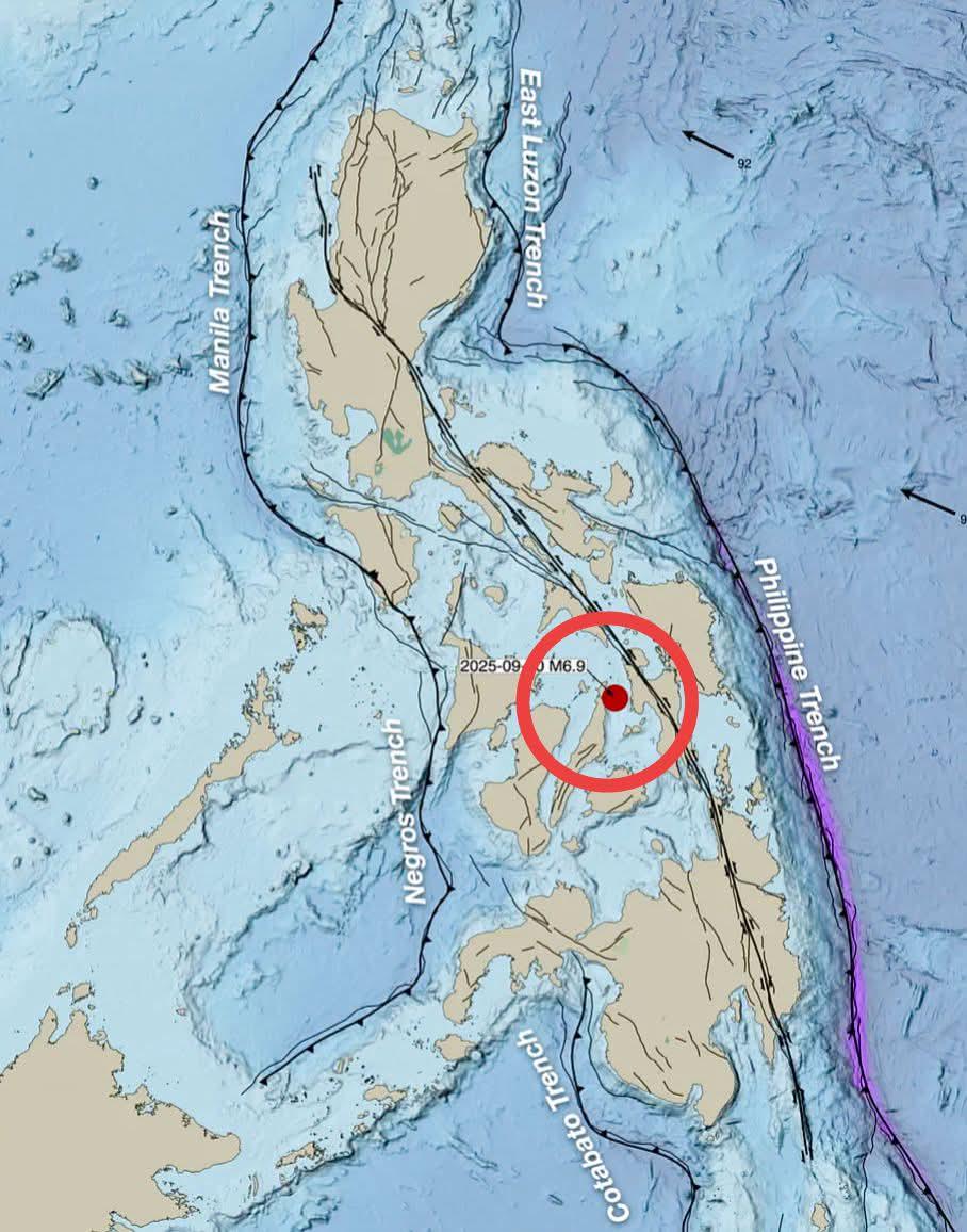
This map illustrates the major and active fault lines and trenches throughout the Philippines, along with the epicenter of a significant magnitude 6.9 earthquake that occurred in Cebu. The visualization highlights the intricate tectonic setting of the archipelago, which is located at the convergence of multiple tectonic plates, including the Philippine Sea Plate and the Eurasian Plate. By pinpointing these fault lines and the earthquake’s epicenter, the map serves as a critical tool for understanding the seismic risks that the region faces.
Deep Dive into Fault Lines and Earthquakes
Fault lines are fractures in the Earth's crust where blocks of land have moved relative to each other. The Philippines, often referred to as the "Ring of Fire," is especially prone to seismic activity due to its position along these tectonic boundaries. Earthquakes occur when stress builds up along these faults, often leading to sudden releases of energy that we experience as tremors.
Interestingly, the occurrence of earthquakes is not uniform across the country. The Philippines has several major fault systems, including the West Valley Fault, the Philippine Fault, and the Marikina Fault. Each of these fault lines is capable of producing significant earthquakes, which can lead to catastrophic consequences for communities in proximity. For instance, the West Valley Fault is known for its potential to generate strong earthquakes, with historical records indicating a cycle of large seismic events approximately every 400 years.
The magnitude 6.9 earthquake that struck Cebu serves as a stark reminder of the seismic hazards in the area. Occurring within a densely populated region, the earthquake caused considerable damage, underscoring the importance of preparedness and awareness regarding seismic risk. The depth and location of the epicenter play critical roles in determining the intensity of the shaking experienced on the surface. In this case, the earthquake’s relatively shallow depth contributed to the damage observed in Cebu and surrounding areas.
According to the Philippine Institute of Volcanology and Seismology (PHIVOLCS), the country experiences thousands of earthquakes each year, although the vast majority are too minor to be felt. However, the potential for larger, more destructive quakes necessitates ongoing monitoring and research. For example, the 1990 Luzon earthquake, which registered a magnitude of 7.8, resulted in over 1,600 fatalities and widespread destruction. Such events highlight the need for rigorous building codes and disaster preparedness plans.
Regional Analysis
Breaking down the seismic activity by region reveals significant variations. For example, Luzon is home to some of the most active faults, including the Philippine Fault Zone, which stretches from the northern tip of the island down to the south. This region has historical precedence for large earthquakes, making it crucial for residents to engage in preparedness activities.
On the other hand, the Visayas region, where Cebu is located, is less active compared to Luzon but still poses notable risks due to its geological features. The presence of the Central Cebu Fault, which runs near the city of Cebu, indicates the potential for seismic events that could impact urban centers. In contrast, Mindanao, situated in the southern part of the Philippines, experiences its own unique seismic behavior, with the Cotabato Fault and other structures contributing to the region's earthquake activity.
What’s fascinating is the interplay between these fault lines and the natural landscape of the Philippines. The rugged terrain, characterized by mountains and valleys, is often shaped by the tectonic forces at work. As a result, our understanding of these geological features not only enhances our knowledge of earthquake risks but also informs land use, urban planning, and environmental conservation efforts.
Significance and Impact
The significance of understanding fault lines and seismic activity in the Philippines cannot be overstated. With a population exceeding 110 million, many living in earthquake-prone areas, the potential impacts of seismic events are profound. Earthquakes can lead to loss of life, displacement of communities, and economic disruption. For instance, the cost of rebuilding after a significant earthquake can run into billions of pesos, affecting the nation’s economy for years to come.
Moreover, ongoing research and monitoring of seismic activity are vital for improving early warning systems and disaster response strategies. As climate change continues to impact global weather patterns, the interplay between natural disasters and human activity grows increasingly complex. Understanding the mapping of fault lines and trenches is essential for developing resilient infrastructure and ensuring the safety of the population.
In conclusion, the map depicting the major and active fault lines and trenches of the Philippines, along with the epicenter of the 6.9 earthquake in Cebu, serves as an essential resource. By fostering awareness and understanding of seismic risks, we can better prepare for the inevitable challenges posed by our dynamic planet.
Visualization Details
- Published
- October 2, 2025
- Views
- 34
Comments
Loading comments...