Damage to Buildings Map Berlin 1945

Alex Cartwright
Senior Cartographer & GIS Specialist
Alex Cartwright is a renowned cartographer and geographic information systems specialist with over 15 years of experience in spatial analysis and data...
Geographic Analysis
What This Map Shows
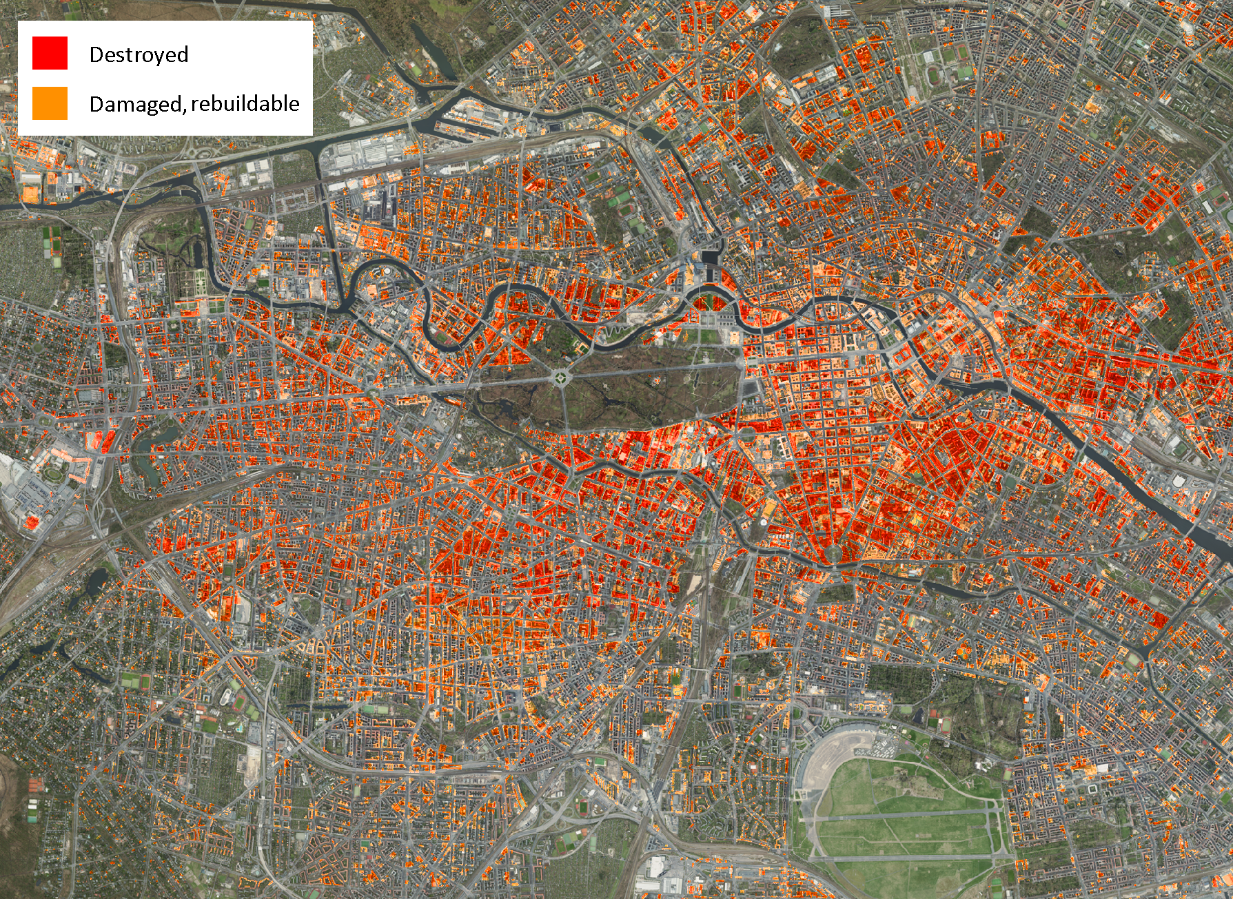
The "Damage to Buildings, Berlin 1945" map provides a stark visual representation of the destruction experienced in Berlin at the end of World War II. Overlaying this historical data onto a modern orthophoto of Berlin in 2024 allows us to compare the scars of war with the vibrant cityscape that exists today. The map visually categorizes the level of damage sustained by buildings during the war—ranging from slight damage to complete destruction—highlighting areas that were particularly affected by aerial bombardments and ground fighting. This juxtaposition of past and present not only serves as a reminder of the city’s turbulent history but also invites us to reflect on the resilience of urban landscapes.
Deep Dive into Building Damage in Berlin 1945
The damage inflicted on Berlin during the final months of World War II was catastrophic. The city, which had been a significant hub of political and military activity, became a battleground as Allied forces closed in. By May 1945, approximately 80% of the city’s buildings were damaged to some extent. This widespread destruction was primarily due to intense aerial bombardments, artillery shelling, and the fierce urban combat that characterized the Battle of Berlin.
Interestingly, the types of damage varied significantly across different districts. For instance, the central districts like Mitte and Tiergarten experienced the most severe destruction. This was largely due to their strategic importance and the concentration of military and administrative buildings. In contrast, areas on the outskirts, such as Spandau and Reinickendorf, while still affected, often showed less devastation. The extent of damage can be directly correlated with the density of military targets in these regions and the tactical approaches employed by both the German and Allied forces.
The classification of damage on the map is crucial for understanding post-war recovery efforts. Buildings that were completely destroyed, marked in red, left gaping holes in the urban fabric, necessitating extensive reconstruction efforts in the following years. Interestingly, the map reflects the resilience of Berliners; many structures were rebuilt, often incorporating modern architectural styles that contrasted sharply with the pre-war aesthetics. This rebuilding phase played a significant role in shaping modern Berlin, leading to a dynamic mix of historical and contemporary architecture.
Regional Analysis
Examining the map closely reveals regional disparities in the level of destruction. In the heart of Berlin, Mitte was almost unrecognizable following the war. Iconic buildings such as the Reichstag and the Berlin Cathedral suffered significant damage, leading to years of restoration work. The area is now a symbol of Germany's reunification and resilience.
On the other hand, neighborhoods like Charlottenburg, which were largely residential, faced a different fate. While many homes were damaged, the nature of the destruction was not as complete as that seen in central areas. This has allowed for a more seamless integration of old and new structures in the area, offering a different narrative of recovery.
In contrast, areas on the periphery, such as Marzahn and Hellersdorf, were less affected during the war. These neighborhoods were largely undeveloped at the time, which meant that they could be planned from scratch in the post-war era. The damage map highlights these variations, showcasing the complex history of urban development in Berlin over the decades.
Significance and Impact
Understanding the damage to buildings in Berlin in 1945 is crucial for several reasons. First, it provides insights into the broader socio-political implications of the war. The destruction of the capital not only affected the physical landscape but also had lasting effects on the identity of Berlin as a city. The narrative of recovery and rebuilding became a cornerstone of post-war German identity, symbolizing resilience and renewal.
Moreover, this topic resonates with contemporary discussions about urban warfare, reconstruction, and heritage preservation. As cities around the world grapple with the impacts of conflict, studying Berlin’s recovery can offer valuable lessons. How can a city rebuild and redefine itself after experiencing such devastation? What strategies can be employed to honor history while embracing modernization? The Berlin example prompts us to consider the delicate balance between remembering the past and moving forward into the future.
In conclusion, the "Damage to Buildings, Berlin 1945" map is more than just a historical document. It encapsulates the city’s journey through destruction and renewal, highlighting the resilience of both its buildings and its people. As we look at Berlin in 2024, it becomes clear that while the marks of war are still visible, the city has transformed into a vibrant metropolis that honors its past while embracing the future.
Visualization Details
- Published
- September 26, 2025
- Views
- 42
Comments
Loading comments...