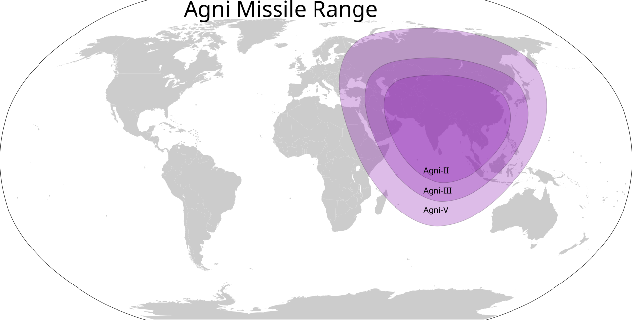
Agni Missile Range Map of India

Marcus Rodriguez
Historical Geography Expert
Marcus Rodriguez specializes in historical cartography and geographic data analysis. With a background in both history and geography, he brings unique...
Geographic Analysis
What This Map Shows
This map provides a detailed visualization of the range of India's Agni missiles, which are capable of delivering nuclear payloads across varying distances. The Agni series consists of several ballistic missiles with medium to intercontinental ranges, showcasing India's strategic capabilities in the realm of defense. The map outlines the geographic reach of these missiles, indicating how far each missile variant can strike from its launch point in India. It serves as a crucial tool for understanding India's military strategy and defense posture in a region marked by complex geopolitical tensions.
Deep Dive into India's Agni Missile Program
India's Agni missile program is a significant component of its defense strategy, developed to enhance national security and deterrence capabilities. The Agni series includes several variants, each designed for specific operational ranges. For instance, Agni-I has a range of approximately 700-1,200 km, while Agni-V can reach targets at distances of up to 5,000 km. What's fascinating is how these capabilities position India as a formidable regional power, capable of projecting influence beyond its immediate borders.
The development of the Agni missiles began in the early 1980s, stemming from India's desire to establish a credible deterrent against potential adversaries, particularly in the context of its historical rivalry with Pakistan and the evolving dynamics with China. Notably, the successful testing of the Agni-V missile in 2012 marked a significant milestone, as it not only showcased advanced technology but also demonstrated India's ability to target cities in far-off regions, including parts of China.
Interestingly, the Agni missile series also underscores the importance of indigenous defense capabilities. Developed by the Defence Research and Development Organisation (DRDO) of India, these missiles are a testament to India's growing technological prowess and commitment to self-reliance in defense. The range of these missiles varies; Agni-II, for example, is designed for a range of about 2,000 km, providing a robust deterrent against regional threats.
Moreover, the strategic positioning of these missiles, as depicted on the map, highlights key military installations and their proximity to potential adversaries. It raises questions about the balance of power in South Asia and the implications for regional stability. The ability to strike targets at significant distances allows India to respond effectively to threats, potentially altering the strategic landscape in the region.
Regional Analysis
When examining the range of the Agni missile series on the map, it's essential to consider the geographical context of South Asia. The range of these missiles allows for varying degrees of coverage across neighboring countries. For instance, Agni-I can reach most of Pakistan and parts of China, while the Agni-V extends into deeper territories, including central China. This capability can create strategic dilemmas for neighboring states, compelling them to reassess their own defense strategies.
Let's consider the implications for Pakistan: with Agni missiles capable of striking major urban centers, it prompts Pakistan to bolster its own defense systems. The recent developments in missile technology and defense systems, such as the Shaheen and Ghaznavi missiles in Pakistan, illustrate a growing arms race in the region. Comparatively, China's advancements in missile technology present another layer of complexity, as India's Agni-V can cover substantial parts of Chinese territory, thus intensifying the strategic calculations of both nations.
Additionally, there are significant differences in the military capabilities and strategies of these countries. While India focuses on a credible minimum deterrent, Pakistan has been developing its strategic capabilities with an emphasis on tactical nuclear weapons, which adds to the volatility of the situation. The map vividly illustrates these dynamics, as it emphasizes the overlap and reach of each country’s missile capabilities, raising crucial questions about regional security and stability.
Significance and Impact
Understanding the range of India's Agni missiles is not merely an academic exercise; it has real-world implications for international relations and security in South Asia. The ability to project power through these ballistic missiles enhances India's standing in global geopolitics, as it seeks to position itself as a responsible nuclear power. Additionally, the missile program reflects India's response to perceived threats and its efforts to maintain strategic stability in a tumultuous region.
Current trends indicate that missile technology will continue to evolve, with nations investing in advanced systems and countermeasures. The implications of this trend are profound, as countries may engage in an escalation of military capabilities, leading to heightened tensions. Future projections suggest that as missile defense systems improve, the dynamics of deterrence may shift, necessitating new strategies and dialogues among nations.
Ultimately, the map of India's Agni missile range serves not just as a representation of military capability but as a critical lens through which to view the strategic landscape of South Asia. As regional dynamics continue to change, understanding these capabilities will be essential for policymakers, analysts, and citizens alike, as they navigate the complexities of international relations in an era of uncertainty.
Visualization Details
- Published
- September 25, 2025
- Views
- 52
Comments
Loading comments...