Ukrainian Boundaries Evolution Map 1917-1921

Marcus Rodriguez
Historical Geography Expert
Marcus Rodriguez specializes in historical cartography and geographic data analysis. With a background in both history and geography, he brings unique...
Geographic Analysis
What This Map Shows
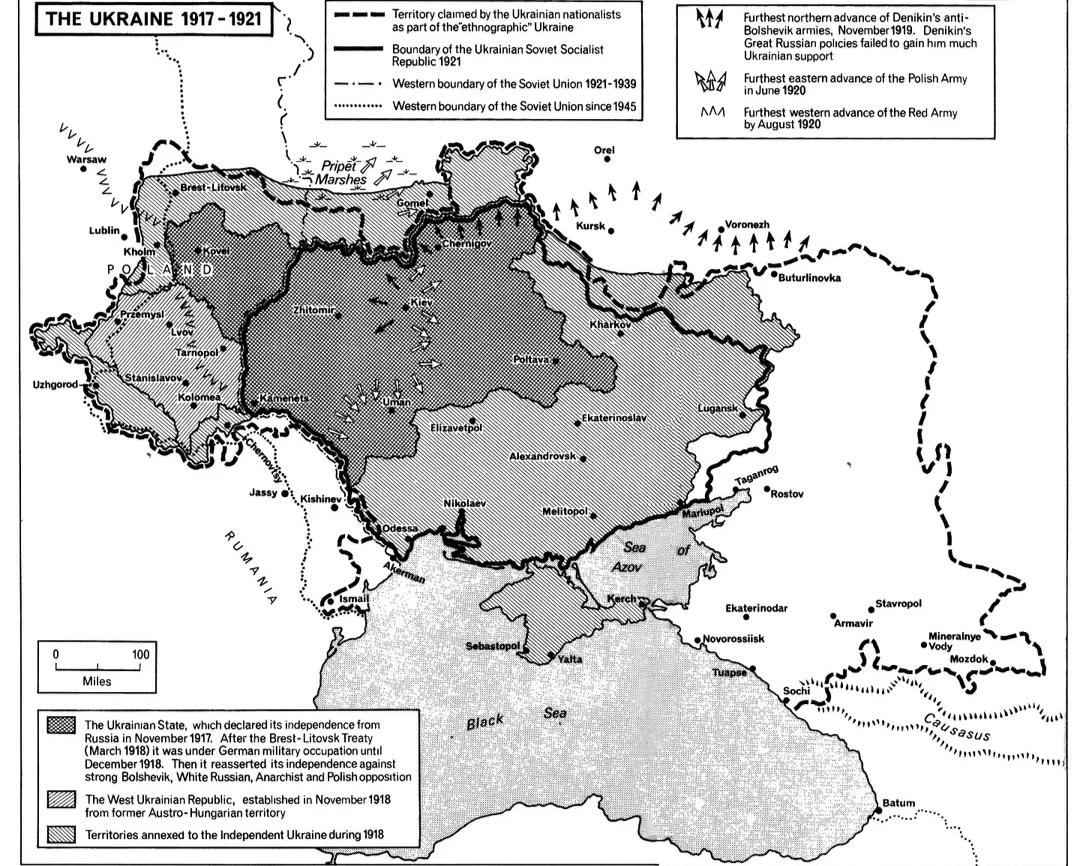
The "Evolution of Ukrainian Boundaries, 1917-1921" map illustrates a tumultuous period in Ukraine's history, showcasing the shifting territorial lines that defined the region during the aftermath of World War I and the Russian Revolution. This visualization captures the complex political landscape in which various factions vied for control, leading to the establishment of multiple governmental entities and fluctuating borders. The map delineates the boundaries of Ukraine as they transformed from the short-lived Ukrainian People's Republic to the Soviet incorporation, revealing not just geographic changes, but also the underlying social and political tensions of the time.
Deep Dive into Ukrainian Territorial Changes
Between 1917 and 1921, Ukraine underwent significant territorial metamorphosis influenced by a myriad of factors including war, revolution, and national movements. Following the collapse of the Russian Empire, Ukraine found itself at the center of competing nationalist aspirations. The Ukrainian People's Republic emerged in 1917, declaring independence from Russia. This was a crucial moment, as it marked the first time modern Ukraine had a chance to assert itself as a sovereign entity.
Interestingly, this period also saw the rise of various political factions, including the Bolsheviks, who were intent on expanding their control over the region. The map vividly illustrates the geopolitical struggle as borders shifted frequently. For instance, in 1918, the Ukrainian People's Republic managed to claim a large part of present-day Ukraine, but faced immediate challenges from both Bolshevik forces and the Central Powers, including Germany and Austro-Hungary, who had their own interests in the area.
As the war progressed, the 1919 Treaty of Versailles and subsequent conflicts further complicated the territorial integrity of Ukraine. The map indicates that by 1920, the Ukrainian Soviet Socialist Republic was established, reflecting the Bolshevik regime's consolidation of power. This marked a significant shift as the region came under Soviet control, drastically altering not just the borders but the socio-political landscape of Ukraine.
Have you ever considered how these historical shifts continue to influence the modern borders and identity of Ukraine? The war and subsequent treaties not only shaped the geographical boundaries but also laid the groundwork for the national identity that we see in Ukraine today. The drastic changes in governance and territorial claims during this period are a testament to the volatile nature of nation-building in post-imperial Europe.
Regional Analysis
Examining the map closely, we can see distinct regional variations in how boundaries evolved during this period. For instance, Western Ukraine, which included parts of Galicia, experienced a different trajectory compared to the eastern regions. The western territories were influenced heavily by Polish and Austro-Hungarian interests, while Eastern Ukraine was more aligned with Russian interests and subsequently fell under Soviet control.
In the south, Crimea was a focal point of contention, switching hands between Ukrainian forces and Bolshevik troops. The shifting borders around this region highlight the strategic importance of Crimea, which has continued to be a hotspot in modern geopolitical discussions. The map’s depiction of these regions emphasizes how historical territorial claims continue to resonate in current political conflicts.
Moreover, the map also showcases how areas like Donbas, which became industrial hubs, were critical during this time. The economic implications of these borders were significant, as control over resources influenced both local and international politics. The changing boundaries not only reflect political aspirations but also the socio-economic realities of the time.
Significance and Impact
Understanding the evolution of Ukrainian boundaries during 1917-1921 is crucial for grasping the complexities of modern Ukrainian identity and politics. The historical context laid down by these shifting borders informs current debates about national sovereignty, regional autonomy, and external influences from neighboring powers.
Interestingly, the repercussions of this period are still felt today. The ongoing conflict in Ukraine, particularly highlighted by Russia's annexation of Crimea in 2014, can be traced back to the unresolved issues stemming from this early 20th-century turmoil. As borders became symbols of national identity, the legacies of the past continue to shape contemporary geopolitical relations.
In conclusion, the map not only serves as a historical record but also as a reminder of the ongoing conversations about national boundaries, identity, and statehood. With current tensions remaining high in the region, understanding the historical context of these territorial changes is more important than ever. It invites us to ask: how will the lessons of history shape the future of Ukraine and its neighbors?
Visualization Details
- Published
- September 25, 2025
- Views
- 60
Comments
Loading comments...