Typhoon Ragasa Impact Map for Hong Kong and Southern China

David Chen
Data Visualization Specialist
David Chen is an expert in transforming complex geographic datasets into compelling visual narratives. He combines his background in computer science ...
Geographic Analysis
What This Map Shows
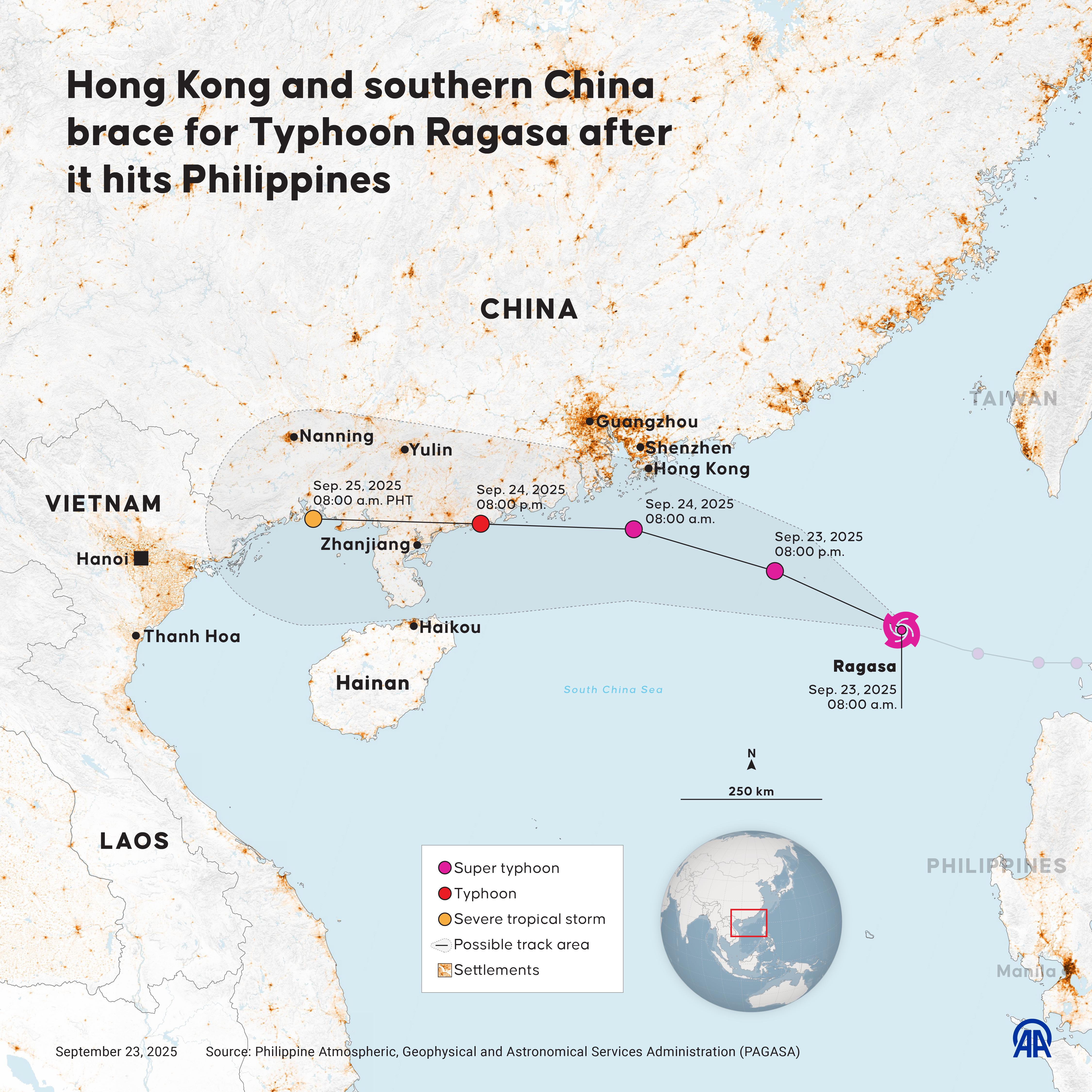
The map titled "Typhoon Ragasa Impact Map for Hong Kong and Southern China" provides a visual representation of the projected path and potential impact areas of Super Typhoon Ragasa as it approaches the southern coast of China. Key features include the areas under red alert for storm surges and high waves, illustrating the urgency of the situation as local authorities prepare for the typhoon's arrival. This map functions not only as a navigational tool but also as a crucial resource for understanding the storm's potential effects on both urban and rural landscapes in the region.
Deep Dive into Typhoon Dynamics
Typhoons, known in other parts of the world as hurricanes or cyclones, are tropical storms characterized by strong winds, heavy rainfall, and the potential for causing significant damage. Super Typhoon Ragasa has garnered attention due to its rapid intensification and trajectory towards densely populated areas in southern China, particularly Hong Kong. In meteorological terms, a super typhoon is classified as a storm with sustained winds exceeding 150 miles per hour (240 kilometers per hour), creating conditions ripe for both devastation and emergency response challenges.
Interestingly, typhoons like Ragasa are a direct result of specific climatic conditions, including warm ocean waters, moist air, and light winds in the upper atmosphere. These factors contribute to the storm's development and intensification. As the typhoon heads towards the coast, the risk of storm surges becomes a critical concern. Storm surges occur when high winds push seawater onto the shore, leading to flooding in low-lying areas. This phenomenon can be exacerbated by high tide conditions, significantly increasing the risk of coastal inundation.
Moreover, the geography of southern China plays a pivotal role in how typhoons impact the region. The coastal cities of Hong Kong and Guangzhou are particularly vulnerable due to their vast populations and infrastructure, which may not be equipped to handle extreme weather events. Have you ever wondered how these cities prepare for such disasters? Emergency services often conduct drills, develop evacuation plans, and establish shelters well ahead of time to mitigate the potential impacts of typhoons.
The economic implications of a typhoon are also profound. In Hong Kong alone, the financial sector is highly sensitive to disruptions caused by extreme weather, impacting stock markets, trade routes, and overall economic stability. The cost of damage can run into billions, affecting not just infrastructure but also public health, education, and local businesses.
Regional Analysis
Examining the regions depicted in the map, we find distinct differences in how various areas prepare for and respond to typhoons. For instance, Hong Kong, with its robust emergency management systems and advanced technology, is generally more prepared than rural areas in southern China. In cities like Guangzhou, while urban infrastructure is developed, the rapid population growth has sometimes outpaced the necessary investments in disaster preparedness.
Additionally, the environmental landscape varies dramatically. Coastal areas with natural barriers, such as mangroves and wetlands, tend to experience less severe impacts from storm surges compared to urbanized regions where such buffers have been removed. For example, the vast concrete expanses in Hong Kong create a channeling effect for floodwaters, increasing the risk of urban flooding. In contrast, areas with preserved natural landscapes may have better resilience against the storm's fury.
Significance and Impact
The significance of Typhoon Ragasa extends beyond immediate weather concerns; it serves as a reminder of the increasing frequency and intensity of typhoons in the era of climate change. As global temperatures rise, ocean waters warm, leading to more powerful storms. This reality compels cities and nations to rethink their disaster preparedness strategies.
What's fascinating is that countries like China are investing heavily in climate adaptation measures, including improved forecasting technologies and infrastructure resilience projects. However, the challenge remains daunting, especially for densely populated urban centers.
As we continue to observe Typhoon Ragasa's trajectory, the map serves as a vital tool for understanding not just the storm's immediate effects, but also the broader implications for urban planning, public safety, and environmental sustainability. The dynamic interplay between geography and meteorology in the context of climate change will continue to shape the experiences of millions living in vulnerable regions.
In conclusion, as we brace for the impact of Typhoon Ragasa, it is crucial to remember the lessons learned from previous storms and to prioritize investments in resilience and preparedness for the future. The fate of coastal communities hinges on our ability to adapt to a changing climate and to safeguard against the forces of nature.
Visualization Details
- Published
- September 23, 2025
- Views
- 82
Comments
Loading comments...