New Zealand Fault Map

David Chen
Data Visualization Specialist
David Chen is an expert in transforming complex geographic datasets into compelling visual narratives. He combines his background in computer science ...
Geographic Analysis
What This Map Shows
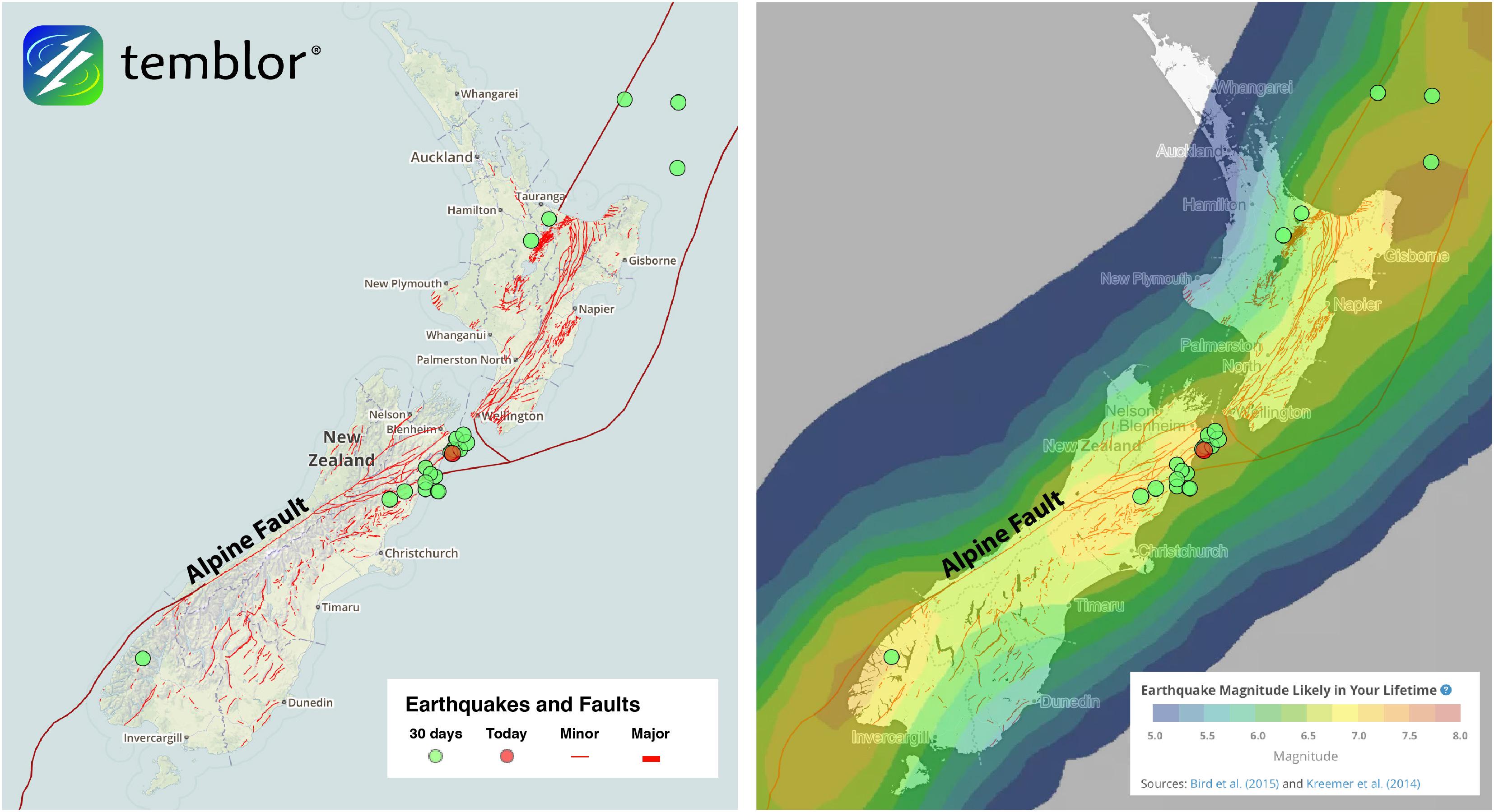
The New Zealand Fault Map visually represents the various fault lines that traverse the landscape of New Zealand, highlighting the tectonic boundaries and seismic activity prevalent in this geologically dynamic region. With its position on the boundary of the Australian and Pacific tectonic plates, New Zealand is one of the most seismically active countries in the world. The map provides a clear depiction of major faults such as the Alpine Fault, the Wellington Fault, and the Hikurangi Subduction Zone, which are crucial to understanding the geological forces at play.
Deep Dive into Tectonic Activity in New Zealand
New Zealand's geology is a fascinating case study in plate tectonics. The country lies on the Pacific Ring of Fire, a region known for its high levels of tectonic activity, including earthquakes and volcanic eruptions. The most significant feature on the map is the Alpine Fault, which runs nearly the entire length of New Zealand's South Island. This fault is responsible for the dramatic landscapes that include the Southern Alps, formed by the collision and uplift of the tectonic plates.
Interestingly, the movement along the Alpine Fault is primarily horizontal, making it a strike-slip fault. This means that the two sides of the fault slide past each other, leading to frequent seismic activity. In fact, the last major earthquake on this fault occurred in 1717, and scientists believe we are overdue for another significant event.
Moreover, the Wellington Fault in the North Island poses a significant risk to the capital city, Wellington. This fault is also a strike-slip fault and has been the site of several historical earthquakes. The proximity of major urban centers to these active faults raises concerns about building codes and preparedness for seismic events.
The Hikurangi Subduction Zone, where the Pacific Plate is being forced beneath the Australian Plate, is another critical area shown on the fault map. This zone is responsible for numerous earthquakes and has the potential for very large seismic events, which could significantly impact the North Island.
New Zealand's seismic landscape also includes volcanic activity, particularly in regions like Rotorua and Taupo, which are part of the Taupo Volcanic Zone. The interaction between fault lines and volcanic systems further complicates the geophysical profile of the country, making it a hotspot for researchers studying tectonic processes.
Regional Analysis
When analyzing different regions in New Zealand based on the Fault Map, we can see distinct seismic characteristics. In the South Island, the presence of the Alpine Fault indicates a higher frequency of earthquakes, especially in areas like Christchurch, which has experienced devastating quakes in recent years. Comparatively, the North Island, while also active, has a different tectonic setup due to the influence of the Hikurangi Subduction Zone.
For instance, Wellington, located near the Wellington Fault, is characterized by its unique geological challenges, necessitating stringent urban planning and building codes designed to withstand seismic events. In contrast, areas like Auckland, further from active faults, might not experience the same level of risk, but they are still vulnerable to the broader impacts of tectonic activity, such as tsunamis and landslides.
Interestingly, the differences in seismic risk across regions lead to varied public awareness and preparedness levels. In cities like Wellington, there’s a strong culture of earthquake preparedness, while in areas with less perceived risk, such as Dunedin, residents may not feel the same urgency.
Significance and Impact
Understanding the fault lines of New Zealand is not just an academic exercise; it has real-world implications for urban planning, disaster preparedness, and environmental management. The country’s seismic activity shapes its infrastructure and influences everything from road construction to emergency response protocols.
Moreover, as climate change continues to affect global weather patterns, the interaction between tectonics and environmental factors could lead to unforeseen challenges. For instance, increased rainfall can exacerbate landslides along fault lines, creating additional risks for communities.
Looking ahead, researchers are focusing on improving earthquake prediction models and developing better building technologies to mitigate the impacts of potential seismic events. The New Zealand Fault Map is a crucial tool for these efforts, providing insights into the complex interplay of geology and human activity in this vibrant country. Understanding these dynamics not only helps safeguard lives but also preserves the unique landscapes that define New Zealand.
Visualization Details
- Published
- September 22, 2025
- Views
- 58
Comments
Loading comments...