Roman Roads of Italy Map

David Chen
Data Visualization Specialist
David Chen is an expert in transforming complex geographic datasets into compelling visual narratives. He combines his background in computer science ...
Geographic Analysis
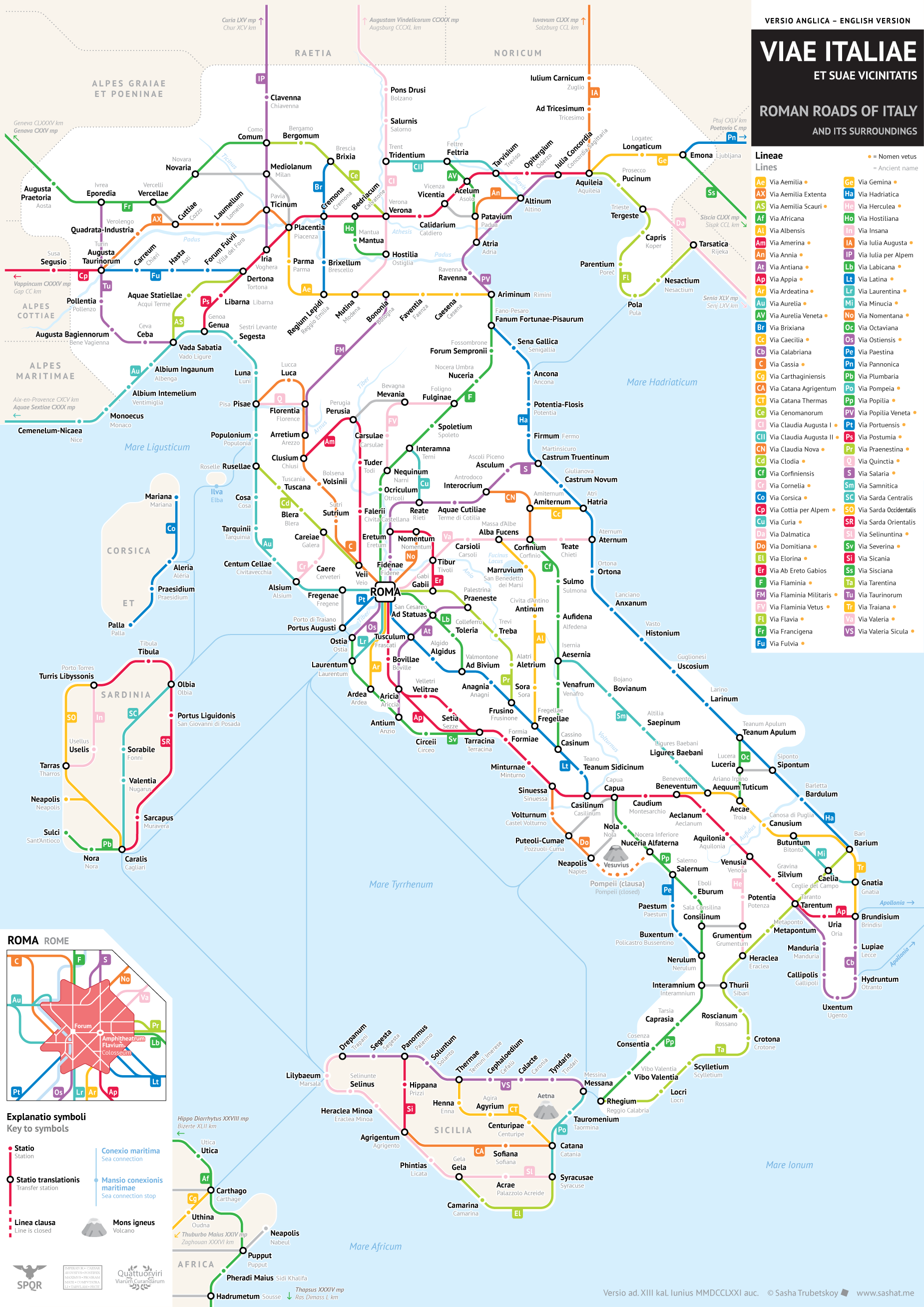
What This Map Shows
The "Roman Roads of Italy Map" provides a visual representation of the extensive network of roads built during the Roman Empire, showcasing not only their routes but also their connections to significant cities and landmarks throughout Italy. This map serves as a testament to the engineering prowess of the Romans and illustrates how these roads facilitated trade, military movements, and cultural exchange across the empire.
Transitioning from the visualization, let’s delve into the actual topic: the Roman roads themselves. These roads were more than mere pathways; they were the veins of the Empire, connecting cities and provinces, allowing for efficient transport and communication. The saying "All roads lead to Rome" reflects the centrality of these roads in the Roman world, emphasizing their importance in unifying the empire.
Deep Dive into Roman Roads
One of the most remarkable aspects of Roman roads is their construction. The Romans utilized advanced engineering techniques, creating roads that were often straight and well-drained. They typically built their roads using multiple layers: a foundation of large stones, a middle layer of smaller gravel, and a top layer of tightly packed stones. Interestingly, many of these roads were designed to withstand heavy traffic, and their durability has allowed some sections to remain in use even today.
Historically, the Roman road system began to develop in the 4th century BCE and expanded significantly throughout the empire, particularly during the 1st and 2nd centuries CE. At its peak, the network spanned over 250,000 miles, with about 50,000 miles being paved. Some of the most famous roads include the Via Appia, which connected Rome to the southern regions of Italy, and the Via Aurelia, which ran along the western coast.
These roads facilitated not just military movements but also commerce and trade. The Romans established milestones every Roman mile (approximately 1,000 paces or 4,841 feet) to indicate distances, which made navigation easier for merchants and travelers alike. Have you ever wondered how goods were transported so efficiently across such distances? The well-maintained roads allowed for the rapid movement of military troops, thus enabling Rome to expand and maintain its territories.
Moreover, the roads were critical for the spread of culture and ideas. They allowed for easier communication between provinces, contributing to the cultural integration of the diverse populations within the empire. The roads were often lined with inns and taverns, providing rest stops for weary travelers and traders.
Regional Analysis
Let's break down the significance of these roads by region based on the map. Northern Italy, for instance, was connected to the rest of the empire through routes like the Via Augusta, which linked the Alps to the Roman territories. This was essential for military movements and trade with Gaul and beyond.
Central Italy, where Rome itself is located, was the hub of the road network. The Via Sacra, the main street of ancient Rome, connected significant landmarks, including the Forum and the Colosseum, showcasing how roads were integrated into urban planning. Interestingly, the development of roads in this area coincided with the rise of Rome as a major power.
Southern Italy featured roads such as the Via Appia, which played a vital role in the Roman conquest of the region. This road connected Rome to the strategic port of Brindisi, illustrating the importance of maritime trade routes alongside land routes. Comparatively, while Northern Italy focused on military logistics, Southern Italy's roads were more about facilitating trade and cultural exchanges with the eastern Mediterranean.
Significance and Impact
The significance of the Roman roads extends far beyond their initial purpose. They laid the groundwork for modern road systems in Europe. Many contemporary highways and routes still follow the paths established by the Romans, a testament to their engineering skills and foresight. Moreover, the infrastructure they created contributed to the economic prosperity of regions throughout the empire.
Current trends in archaeological research continue to uncover the past, revealing how these ancient roads influenced urban development and settlement patterns in Italy. As modern cities grow and evolve, understanding the historical significance of these roads offers insights into how infrastructure shapes societies.
In conclusion, the Roman Roads of Italy were more than mere routes; they were vital arteries that fueled the lifeblood of an empire. Their legacy is seen not only in historical texts but also in the very roads we traverse today. The study of these roads provides a fascinating glimpse into the interplay between geography, culture, and history, reminding us of the enduring impact of ancient civilizations on our modern world.
Visualization Details
- Published
- September 21, 2025
- Views
- 58
Comments
Loading comments...