Map of the Heartland of the Ancient Greeks

David Chen
Data Visualization Specialist
David Chen is an expert in transforming complex geographic datasets into compelling visual narratives. He combines his background in computer science ...
Geographic Analysis
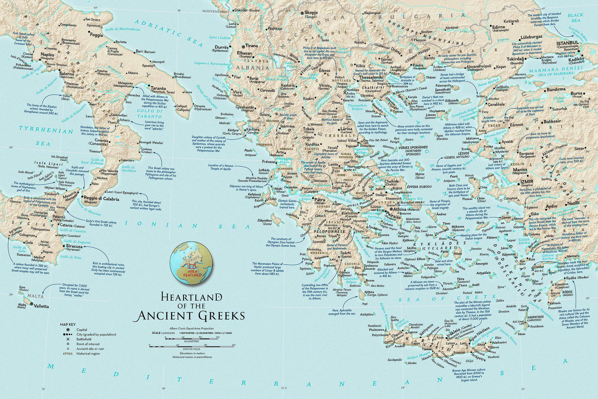
What This Map Shows
The "Heartland of the Ancient Greeks" map intricately outlines the geographical areas that were pivotal to the development of Greek civilization. It showcases regions such as Attica, Peloponnese, and the islands of the Aegean Sea, which played crucial roles in the political, cultural, and economic life of ancient Greece. The map highlights not only the land but also the proximity of various city-states, trade routes, and significant geographical features like mountains and coastlines that shaped the life and interactions of the ancient Greeks.
Deep Dive into Ancient Greek Geography
The heartland of ancient Greece was characterized by its diverse geography, which significantly influenced its development. To begin, the rugged terrain, marked by mountains and valleys, created natural barriers between communities. This fragmentation led to the formation of independent city-states (poleis) like Athens, Sparta, and Corinth, each developing its own culture and governance structures. Ever wondered why these city-states often competed? The geographical layout fostered a sense of local identity over a unified national identity.
Interestingly, the ancient Greeks were adept at navigating their environment. The Aegean Sea served not only as a barrier but also as a highway for trade and cultural exchange. The map reveals the strategic positions of ports such as Piraeus, which became the main harbor of Athens, facilitating trade with other Mediterranean cultures. This maritime prowess was pivotal for the economy, allowing for the importation of grain, metals, and luxury goods.
Climate played a crucial role as well. The Mediterranean climate, characterized by hot, dry summers and mild, wet winters, allowed for the cultivation of olives and grapes. These crops were not only staples of the Greek diet but also critical for trade. The map indicates agricultural regions, which thrived due to the fertile plains in areas like Thessaly, contrasting sharply with the more arid landscapes of southern Greece.
In terms of demographics, the population of ancient Greece was diverse, consisting of citizens, metics (foreign residents), and slaves. The map allows us to understand how geographic factors influenced settlement patterns. For example, the population density around Athens was significantly higher than in the more rural regions of Epirus. This concentration fostered a vibrant cultural and intellectual life, which was evident in the flourishing of art, philosophy, and democracy.
Regional Analysis
Breaking down the map by region, we can see distinct characteristics that shaped each area. In Attica, the location of Athens, the combination of access to the sea and fertile land led to explosive growth. The city's influence extended far beyond its borders, making it a cultural hub of the ancient world.
Contrastingly, the Peloponnese, home to Sparta, emphasized military prowess and austerity. Its geography, with fewer natural harbors and a focus on land-based power, shaped a society centered around discipline and combat training. Interestingly, the rivalry between Athens and Sparta can be traced back to these geographical and cultural differences.
The islands of the Aegean, such as Crete and Rhodes, were crucial players in maritime trade. The map shows how these islands served as waystations for goods and ideas, facilitating contact between Greeks and other ancient civilizations, including the Egyptians and Phoenicians. This trade network was essential for the diffusion of cultural practices and technologies.
Significance and Impact
Understanding the heartland of the ancient Greeks through this map is vital for several reasons. Firstly, it illustrates how geography can shape political and social structures. The fragmented nature of the landscape led to the rise of city-states, which in turn influenced the development of democracy, philosophy, and art that we still celebrate today.
Moreover, this geographical context helps us comprehend the historical conflicts that arose, such as the Peloponnesian War, rooted in both territorial disputes and differing ideologies fostered by their environments. Current discussions on regionalism and local governance can draw parallels from these ancient dynamics.
Looking to the future, the legacies of ancient Greece continue to inform contemporary society. The lessons learned from their geographical challenges—like resource management and trade routes—are increasingly relevant as modern nations navigate globalization and environmental sustainability. The map not only acts as a historical reference but also as a reminder of the enduring impact of geography on human civilization.
The heartland of the ancient Greeks is not merely a relic of the past; it is a testament to how the landscapes we inhabit shape our cultures, economies, and identities. As we study this map, we gain valuable insights into the complexities of human history and relationships with the land.
Visualization Details
- Published
- September 17, 2025
- Views
- 74
Comments
Loading comments...