Indigenous North Americans Population Distribution Map

Alex Cartwright
Senior Cartographer & GIS Specialist
Alex Cartwright is a renowned cartographer and geographic information systems specialist with over 15 years of experience in spatial analysis and data...
Geographic Analysis
What This Map Shows
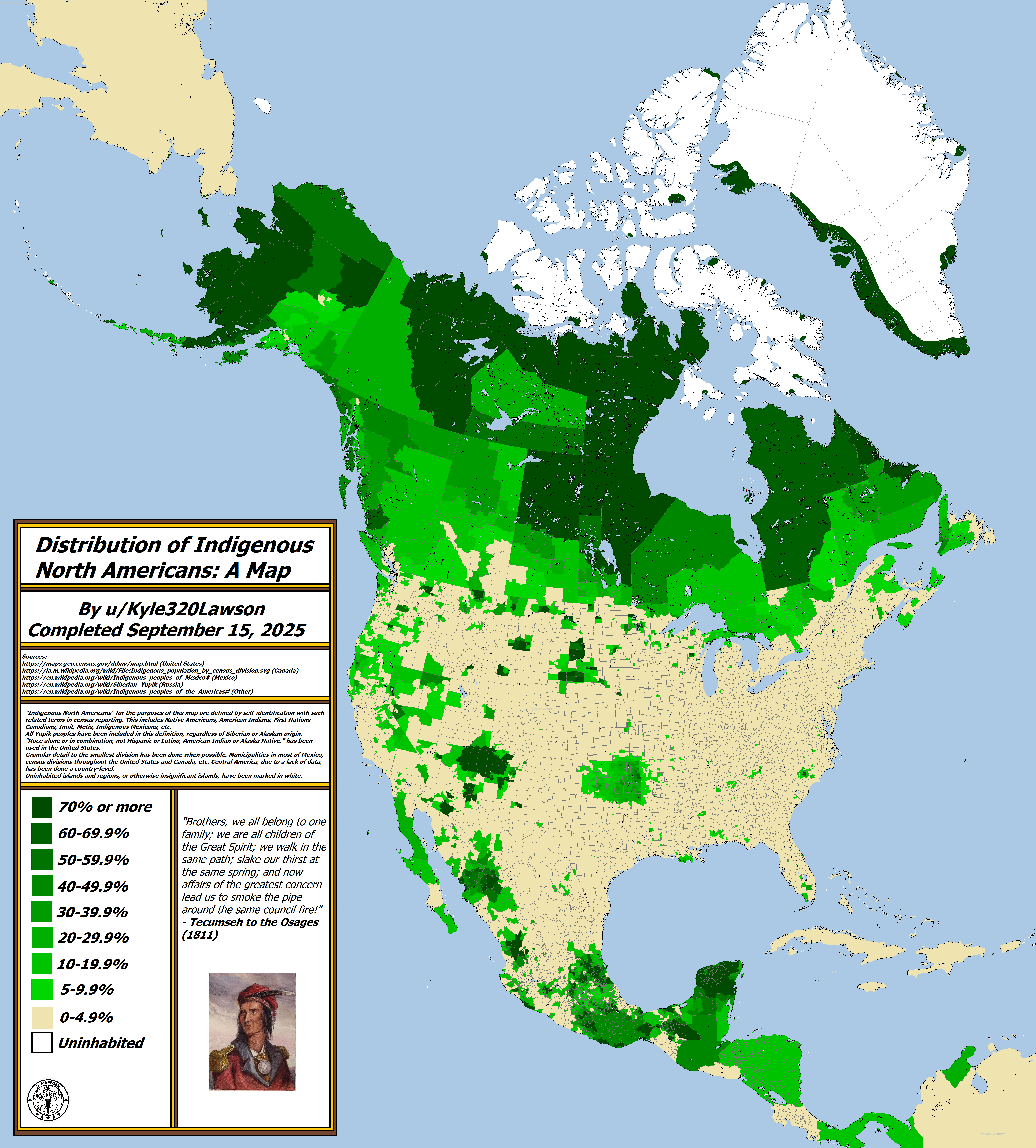
The "Distribution of Indigenous North Americans: A Map" provides a comprehensive visual representation of where Indigenous populations are located across North America, including the United States, Canada, and Mexico. This map focuses on the self-identification of individuals as Indigenous, encompassing a variety of groups such as Native Americans, First Nations, Inuit, Métis, Indigenous Mexicans, and Yupik peoples, regardless of their geographical origins. By utilizing granular census data, the map illustrates the distribution patterns of these populations down to the municipal level in Mexico and through census divisions in the United States and Canada. This detailed approach highlights not only the populations but also the diverse cultural heritage and historical significance of Indigenous communities.
Deep Dive into Indigenous Populations
The Indigenous peoples of North America represent a rich tapestry of cultures, languages, and traditions that have thrived for thousands of years. Interestingly, the term "Indigenous" encompasses a wide range of identities, each with its unique customs and histories. For instance, in the United States, the Census Bureau identifies Indigenous individuals through the classification of American Indian and Alaska Native, which may include over 574 federally recognized tribes.
In Canada, the Indigenous population is often categorized into three main groups: First Nations, Inuit, and Métis. Each of these groups has distinct rights and cultural identities, shaped by their historical experiences and relationships with the land. In Mexico, Indigenous peoples also play a vital role in the nation's cultural identity, with approximately 25 million individuals identifying as Indigenous, representing hundreds of different ethnic groups and languages.
Diving deeper into the data, the map reveals that the highest concentrations of Indigenous peoples can be found in specific regions. In the United States, states such as Alaska, New Mexico, and South Dakota have significant Indigenous populations, reflecting historical settlement patterns and treaties. Alaska is home to many Native groups, including the Iñupiat and Tlingit, while New Mexico boasts a large number of Pueblo tribes. The Pine Ridge Reservation in South Dakota is one of the largest Native American reservations in the U.S., home to the Lakota Sioux Tribe.
In Canada, Indigenous populations are particularly prominent in the northern territories, such as Nunavut, where Inuit communities thrive. The map indicates that these areas are not only home to Indigenous peoples but also encompass vast tracts of land that hold cultural significance and traditional practices.
Moving south to Mexico, the highest Indigenous populations are found in states such as Oaxaca and Chiapas, where communities like the Zapotecs and Tzeltals maintain their languages and traditions despite external pressures. In these regions, the legacy of colonialism can still be felt, as many Indigenous groups continue to advocate for their rights and recognition.
Regional Analysis
When analyzing the map regionally, it becomes evident that certain areas exhibit higher densities of Indigenous populations than others. For instance, the western United States is characterized by a mosaic of tribal lands and significant Indigenous influence in local governance and culture. In contrast, the eastern United States has seen a more fragmented Indigenous presence due to historical displacement and assimilation policies.
Interestingly, the Canadian provinces show a more concentrated pattern of Indigenous habitation, particularly in areas where treaties were historically established. For example, British Columbia has a high number of Indigenous languages and cultures, with groups like the Coast Salish significantly impacting local heritage.
In Mexico, the southern states stand out as cultural hubs for Indigenous communities, where vibrant markets, traditional clothing, and festivals highlight their rich heritage. This regional variation indicates the diverse experiences of Indigenous peoples across North America, shaped by geography, history, and socio-political dynamics.
Significance and Impact
Understanding the distribution of Indigenous populations in North America is crucial for various reasons. Firstly, it sheds light on the cultural diversity that exists within the continent, emphasizing the importance of preserving languages, traditions, and rights. Furthermore, this map can serve as a tool for policymakers and advocates working to improve the living conditions and rights of Indigenous peoples.
Current trends indicate a growing recognition of Indigenous rights, particularly in Canada and the U.S., where movements for land rights and cultural preservation have gained momentum. However, challenges remain, including socioeconomic disparities and ongoing impacts of colonization. As we move forward, it is vital to consider the voices and perspectives of Indigenous communities in discussions about land use, environmental conservation, and cultural heritage.
In conclusion, the "Distribution of Indigenous North Americans: A Map" not only serves as a visual tool but also invites us to reflect on the past, present, and future of Indigenous peoples across North America. Understanding where these populations reside is fundamental in fostering respect, recognition, and reconciliation in our multicultural societies.
Visualization Details
- Published
- September 15, 2025
- Views
- 60
Comments
Loading comments...