Habsburg Territories Map 1700-1814

Marcus Rodriguez
Historical Geography Expert
Marcus Rodriguez specializes in historical cartography and geographic data analysis. With a background in both history and geography, he brings unique...
Geographic Analysis
What This Map Shows
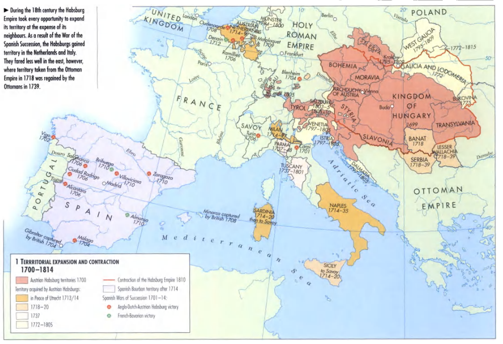
The "Habsburg Territories Map 1700-1814" presents a detailed visualization of the extensive lands held by the Habsburg dynasty during a pivotal period in European history. This era, marked by wars, treaties, and shifting alliances, reflects the vast influence of the Habsburgs across Europe. The map highlights regions such as Austria, parts of modern-day Italy, Spain, and significant territories in Central and Eastern Europe, illustrating the sprawling nature of their empire and the complexity of their political landscape.
Deep Dive into the Habsburg Empire
The Habsburg dynasty, one of the oldest and most influential royal families in European history, was characterized by its diverse and multicultural territories. At its zenith in the early 18th century, the Habsburg Empire encompassed a significant portion of Central Europe, including Austria, Hungary, Bohemia, and the Low Countries, while also extending its reach into Italy and Spain. This unique configuration was the result of strategic marriages, military conquests, and political alliances that allowed the Habsburgs to consolidate power in various regions.
Interestingly, the map illustrates how the Habsburg territories were not just a conglomeration of lands but a mosaic of cultures, languages, and religions. For instance, in the Kingdom of Hungary, the Habsburgs ruled over a diverse population that included Magyars, Slovaks, Romanians, and Serbs, each contributing to the rich social tapestry of the region. The coexistence of such varied groups often led to tensions and uprisings, particularly in the context of national identity and autonomy.
The map also sheds light on the political significance of the Habsburg domains. The dynasty played a central role in the power struggles of Europe, particularly during the War of Spanish Succession (1701-1714) and the subsequent conflicts that involved various European powers. The Habsburgs' control over strategic territories like the Spanish Netherlands and parts of Italy allowed them to exert considerable influence over trade routes and military movements, shaping the geopolitical landscape of Europe during this period.
Moreover, the Habsburg Empire was notable for its unique administrative structure, which often varied from one region to another. For instance, the dual monarchy of Austria-Hungary, established later in 1867, was foreshadowed by the complex governance systems that the Habsburgs employed in their territories. This administrative diversity is reflected in the map, showcasing how the Habsburgs managed to maintain cohesion in a vast and varied empire.
Regional Analysis
When analyzing the Habsburg territories on the map, it's essential to consider the distinct characteristics of various regions. In Central Europe, for example, Austria and Bohemia were central to Habsburg power, serving as the political and cultural heart of the empire. Vienna, the capital, became a hub for arts and sciences, attracting intellectuals and artists from across Europe. The architectural legacy of this era, visible in the grand palaces and public buildings, still influences the cultural landscape of modern Austria.
Contrast this with the Habsburg control of the Spanish territories. The Spanish Netherlands, now Belgium, was a significant economic center during this time, known for its flourishing textile industry and vibrant trade networks. The cultural impact of the Habsburgs is evident in the art and architecture of cities like Brussels and Antwerp, which were pivotal in the Renaissance and Baroque movements.
Furthermore, the Habsburg influence extended into Italy, where regions such as Lombardy and the Kingdom of Naples showcased the dynasty's ability to integrate diverse cultures. The map highlights how these territories often experienced a blend of Italian and Habsburg influences, resulting in unique regional identities that contributed to Italy's rich historical narrative.
Significance and Impact
Understanding the Habsburg territories is crucial for grasping the broader implications of European history during the 18th century. The map not only illustrates territorial holdings but also emphasizes the intricate web of alliances and conflicts that defined the period. The Habsburgs' strategic marriages and territorial expansions played a pivotal role in shaping the political landscape of Europe, leading to significant historical events like the Thirty Years' War and the eventual rise of nationalism in the 19th century.
Moreover, the legacy of the Habsburg Empire continues to resonate today. The cultural, linguistic, and political influences established during this time have laid the groundwork for modern Central and Eastern Europe. As we look to the future, understanding the historical context provided by the Habsburg territories can offer insights into contemporary issues related to national identity, cultural heritage, and regional cooperation.
In summary, the "Habsburg Territories Map 1700-1814" is more than just a geographic representation; it is a window into a complex historical narrative that highlights the significance of territorial control, cultural diversity, and political power in shaping modern Europe.
Visualization Details
- Published
- September 13, 2025
- Views
- 94
Comments
Loading comments...