Driving Direction Map in Europe, 1922

Marcus Rodriguez
Historical Geography Expert
Marcus Rodriguez specializes in historical cartography and geographic data analysis. With a background in both history and geography, he brings unique...
Geographic Analysis
What This Map Shows
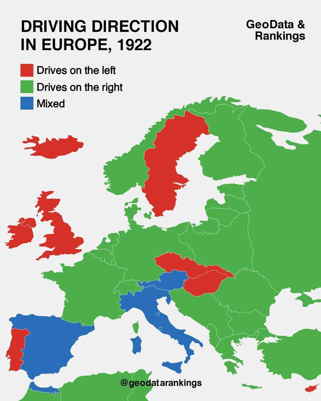
The "Driving Direction Map in Europe, 1922" is a fascinating historical document that reveals the driving conventions and regulations of various European countries during the early 20th century. This map is particularly noteworthy as it illustrates the different practices adopted by nations regarding which side of the road vehicles were required to drive on. At a time when motor vehicles were becoming more common, this map reflects not only the state of road infrastructure but also the cultural and political differences that existed across Europe.
Deep Dive into Driving Regulations in Early 20th Century Europe
In the early 1920s, the landscape of motoring was rapidly changing. With the rise of the automobile after World War I, countries began to establish formal traffic regulations, including driving directions. Interestingly, the map indicates a clear division between nations that drove on the left side versus those that drove on the right. For instance, the United Kingdom, Ireland, and a few other territories maintained left-hand driving, a tradition stemming from historical practices that favored right-handedness for sword-wielding knights. Conversely, most of mainland Europe adopted right-hand driving, influenced by the need for coherence in cross-border travel, particularly as roads became more interconnected.
The adoption of these driving regulations was not merely a matter of convenience; it was deeply intertwined with national identity and international relations. Countries like France and Germany, which had significant motor vehicle manufacturing industries, pushed for standardization to facilitate trade and travel. By 1922, the differences were stark: while the UK clung to its left-hand traditions, nations like France had already begun implementing right-hand traffic laws in the early 1900s, a shift that stemmed from their own efforts to modernize and align with their neighbors.
Furthermore, the driving direction is indicative of broader societal shifts regarding mobility. The increasing popularity of automobiles was transforming urban landscapes, leading to the development of new road systems and infrastructure. These changes had lasting implications for city planning and public policy, as governments began to invest heavily in road construction and traffic regulation to ensure safety and efficiency.
Regional Analysis
When examining the map regionally, one can see distinct patterns that emerge. In Western Europe, countries like France, Belgium, and the Netherlands adopted right-hand driving, which facilitated smoother travel across borders. The interconnectedness of these nations was further enhanced by the establishment of the first formal motorways, such as Germany's Autobahn, which was being conceptualized during this time.
In contrast, the United Kingdom and its colonies remained steadfast in their left-hand practice. This divergence is particularly pronounced when looking at the British Isles versus continental Europe. For travelers crossing the English Channel, the shift from left to right was a significant adjustment, highlighting the cultural barriers that extended beyond mere geography.
Interestingly, Scandinavian countries like Sweden, which initially favored left-hand driving, eventually transitioned to right-hand driving in 1967. This shift was influenced by the need for consistency with neighboring countries and the increasing volume of cross-border traffic. Such examples demonstrate that the driving direction has historical roots but also reflects ongoing adaptations to the changing landscape of transportation.
Significance and Impact
Understanding the driving direction regulations of the early 20th century holds contemporary relevance. Today, as European nations continue to integrate more closely through the European Union, the implications of historical driving practices can still be felt. The harmonization of traffic laws has been a significant focus for policymakers aiming to enhance road safety and facilitate international travel.
Moreover, as we consider future projections, the evolution of transportation technology, including electric vehicles and autonomous driving, may lead to new discussions about road regulations and safety practices. The legacy of driving directions in Europe serves as a reminder of how cultural identity, technology, and policy can shape the mobility of people and goods across borders.
Ultimately, the "Driving Direction Map in Europe, 1922" is more than just a historical artifact; it’s a reflection of societal values and the interplay of geography and culture that continues to influence our world today. Have you ever wondered how much our driving habits have changed since then, or how they might evolve in the future? The road ahead is certainly an intriguing one.
Visualization Details
- Published
- September 9, 2025
- Views
- 46
Comments
Loading comments...