Atlantic Ocean Floor Map

Alex Cartwright
Senior Cartographer & GIS Specialist
Alex Cartwright is a renowned cartographer and geographic information systems specialist with over 15 years of experience in spatial analysis and data...
Geographic Analysis
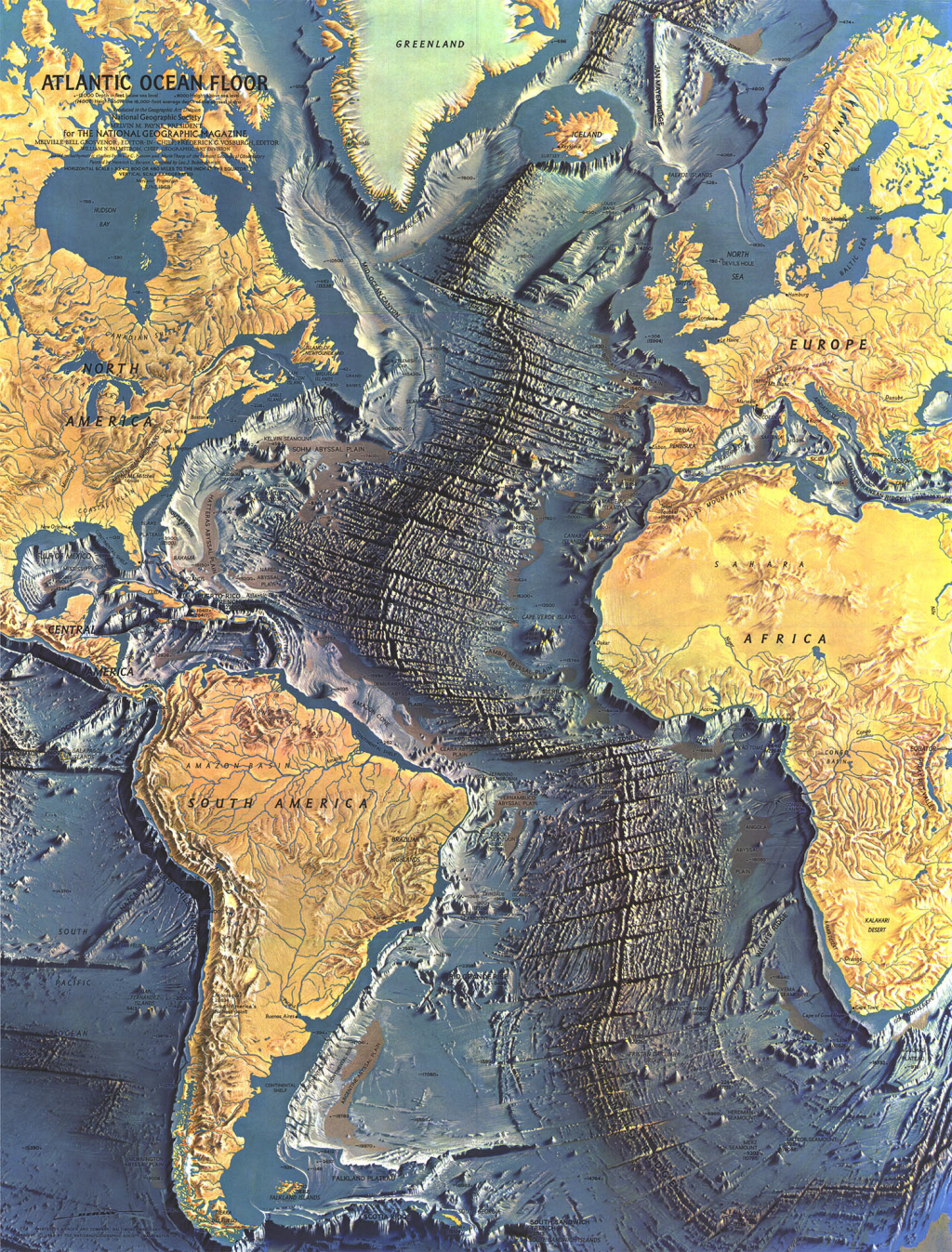
What This Map Shows\nThe 1968 map of the Atlantic Ocean Floor by Heinrich Caesar Berann is a striking visualization that displays the complex underwater landscape of the Atlantic Ocean. This map highlights the oceanic features such as mid-ocean ridges, deep-sea trenches, and continental shelves in vivid detail. By employing a combination of color and shading, Berann provides a comprehensive view of the ocean floor's topography, enabling viewers to appreciate the geological processes shaping our planet's largest bodies of water.
However, this map does more than just depict the ocean floor; it invites us to explore the intricate systems that govern ocean dynamics and their profound influence on global climate, marine biodiversity, and human activities.
Deep Dive into Ocean Floor Features\nThe Atlantic Ocean is not just a vast expanse of water; it's a complex environment filled with various geological features. The ocean floor can be categorized into several significant zones, each playing a crucial role in oceanic and ecological processes.
One of the most prominent features on the Atlantic Ocean floor is the Mid-Atlantic Ridge, an underwater mountain range that runs down the center of the Atlantic. This ridge is a divergent plate boundary where tectonic plates move away from each other, allowing magma to rise and create new oceanic crust. Interestingly, this process is responsible for a significant amount of seismic activity in the region, including underwater volcanic eruptions.
In addition to the Mid-Atlantic Ridge, the ocean floor houses deep-sea trenches, such as the Puerto Rico Trench. This trench is the deepest point in the Atlantic Ocean, reaching depths of over 8,400 meters (27,600 feet). These trenches are formed by subduction, where one tectonic plate moves under another, leading to the creation of some of the most extreme environments on Earth.
The continental shelves surrounding the Atlantic are also critical to understanding the ocean floor. These shelves are areas of shallow water adjacent to coastlines, rich in nutrients and biodiversity. They serve as vital ecosystems for marine life, supporting fisheries that are crucial for food security in many coastal communities. The depth of the continental shelf varies from region to region, influencing the types of marine species that can thrive there. For example, the wider continental shelf off the coast of the United States supports diverse fisheries, while the steeper shelves of the Caribbean limit such biodiversity.
Regional Analysis\nWhen analyzing the Atlantic Ocean floor, it's essential to break it down into distinct regions to understand the variations in geological features and their implications. The North Atlantic, for example, is characterized by the prominent Mid-Atlantic Ridge and features like the Icelandic hotspot, which has created the island of Iceland through volcanic activity. The region is also crucial for understanding ocean currents, such as the North Atlantic Drift, which influences climates far beyond the ocean.
Conversely, the South Atlantic presents a different picture. The continental shelf is narrower than in the North, leading to fewer rich fishing grounds. However, the South Atlantic also contains significant underwater features, such as the Brazil Basin and the Falkland Plateau, which have been the focus of geological studies for their unique sedimentary processes.
Interestingly, the Caribbean Sea, while technically part of the Atlantic Ocean, features its own distinct ocean floor characteristics, including coral reefs and seamounts that support diverse marine life. The interactions between these regions illustrate the complexity of oceanic systems and their ecological significance.
Significance and Impact\nThe features of the Atlantic Ocean floor are not merely geological curiosities; they have real-world implications for climate, marine ecosystems, and human economic activities. For instance, the Mid-Atlantic Ridge is a significant site for understanding plate tectonics and the geological history of our planet. The volcanic activity along this ridge contributes to nutrient cycling in the ocean, which is essential for sustaining marine life.
Moreover, the ocean floor's geological features influence ocean currents, which play a vital role in regulating weather patterns and climate. For example, the Gulf Stream, a warm ocean current originating in the Gulf of Mexico, travels up the East Coast of the United States and across the Atlantic to Europe, significantly affecting the climate of these regions.
As we look to the future, understanding the Atlantic Ocean floor is becoming increasingly important in light of climate change. The ocean's ability to absorb carbon dioxide and its role in global warming are closely tied to ocean floor dynamics. Furthermore, as human activities expand into oceanic territories, such as deep-sea mining and oil exploration, the need for comprehensive mapping and understanding of these underwater landscapes becomes crucial to protect marine ecosystems.
In conclusion, the Atlantic Ocean Floor Map by Heinrich Caesar Berann serves as a vital tool for understanding the complex interplay of geological features and their implications for both our planet and its inhabitants. By appreciating the depths of the Atlantic, we can better grasp the challenges and opportunities that lie ahead in the realm of oceanic studies.
Visualization Details
- Published
- September 8, 2025
- Views
- 74
Comments
Loading comments...