Ottoman Empire Map of 1683

Alex Cartwright
Senior Cartographer & GIS Specialist
Alex Cartwright is a renowned cartographer and geographic information systems specialist with over 15 years of experience in spatial analysis and data...
Geographic Analysis
What This Map Shows
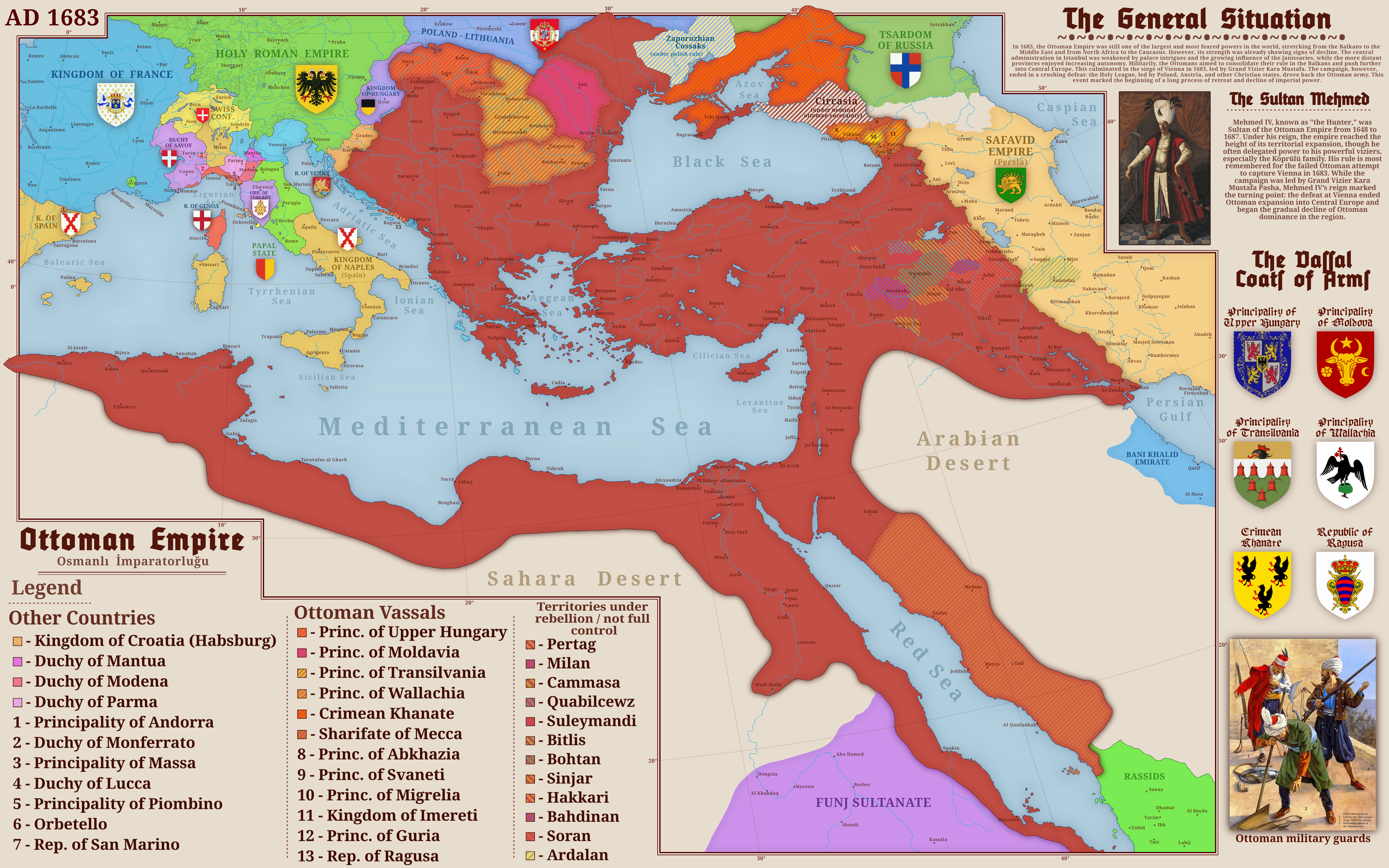
The map titled "The Ottoman Empire in 1683" provides a visual representation of the territorial expanse of the Ottoman Empire at a pivotal moment in its history. Specifically, it captures the empire's geographical boundaries, major cities, and significant regions, illustrating not only the vastness of its influence but also the complexity of its administration. The year 1683 is crucial as it marks the last major attempt by the Ottomans to expand into Europe, culminating in the siege of Vienna. This visualization allows us to understand the strategic importance of the empire during this period and how its territories were interconnected.
Deep Dive into the Ottoman Empire
The Ottoman Empire, founded around 1299, evolved into one of the most enduring and influential empires in history, spanning three continents: Europe, Asia, and Africa. By 1683, the empire was at its zenith, controlling significant territories that included parts of modern-day Turkey, the Balkans, the Middle East, and North Africa. Interestingly, the empire's success was largely due to its unique administrative structure, which integrated diverse cultures and religions under a single political umbrella.
One fascinating aspect of the Ottoman Empire was its millet system, which allowed various religious communities to govern themselves under their own laws while remaining loyal to the sultan. This system not only facilitated governance over a vast and diverse population but also promoted cultural and religious pluralism. At its height, the empire was home to Muslims, Christians, and Jews, each contributing to the rich tapestry of Ottoman society.
The economy of the Ottoman Empire during this period was predominantly agrarian, with agriculture serving as the backbone. Major crops included grains, fruits, and vegetables, which were crucial for both sustenance and trade. Cities such as Istanbul (then Constantinople), Cairo, and Baghdad emerged as vital trade hubs that connected Europe and Asia, facilitating the exchange of goods, ideas, and cultures.
The military prowess of the Ottomans was another critical factor in their expansion. The empire's well-trained janissaries, elite infantry units, played a significant role in both territorial conquests and defending its borders. The strategic location of the empire allowed it to control key trade routes, such as the Silk Road and spice trade, which not only enriched the empire but also enhanced its political power.
Regional Analysis
Examining the map reveals distinct regional differences within the Ottoman Empire. For instance, the Balkan territories were among the first European regions to be integrated into the empire and remained pivotal due to their geographic location and cultural diversity. Cities like Belgrade and Sofia served as important military outposts and administrative centers during this period.
In contrast, the Middle Eastern territories, including present-day Iraq and Syria, were significant for their economic contributions, particularly through agriculture and trade. The cities of Damascus and Mosul were not only vital for trade networks but also cultural centers that influenced art, science, and philosophy. The Ottoman influence in the region was profound, as it blended local customs with imperial governance.
North Africa, particularly Egypt and Libya, showcased another dimension of Ottoman influence. Egypt stood out as a vital grain supplier for the empire, while its strategic position allowed for control over trade routes in the Mediterranean. The rich agricultural land along the Nile and the vibrant trade in Alexandria highlighted the economic significance of this region.
Significance and Impact
Understanding the geographical scope and administrative structure of the Ottoman Empire in 1683 is crucial for grasping the historical context of modern geopolitical boundaries in Europe, the Middle East, and North Africa. The empire's legacy persists in contemporary cultural, religious, and political landscapes, reminding us of the complex interplay of unity and diversity.
Furthermore, the Ottoman Empire's decline in the late 17th century set the stage for future conflicts and nationalistic movements in Europe and the Middle East. As we examine current geopolitical trends, it’s evident that the historical borders laid down by the Ottomans continue to influence modern state relations and conflicts. The map serves not just as a snapshot of a past empire but as a reflection of ongoing dialogues about identity, culture, and governance in regions shaped by Ottoman rule.
In conclusion, the Ottoman Empire in 1683 was a complex entity that intertwined diverse cultures and economies under a single political framework. Its historical significance extends beyond the past, offering insights into the present-day dynamics of the regions it once controlled. Have you ever considered how the legacies of such empires still resonate in our world today? The map invites us to explore these connections and understand the historical roots of contemporary issues.
Visualization Details
- Published
- September 6, 2025
- Views
- 108
Comments
Loading comments...