Territorial Changes of Russia Map

Alex Cartwright
Senior Cartographer & GIS Specialist
Alex Cartwright is a renowned cartographer and geographic information systems specialist with over 15 years of experience in spatial analysis and data...
Geographic Analysis
What This Map Shows
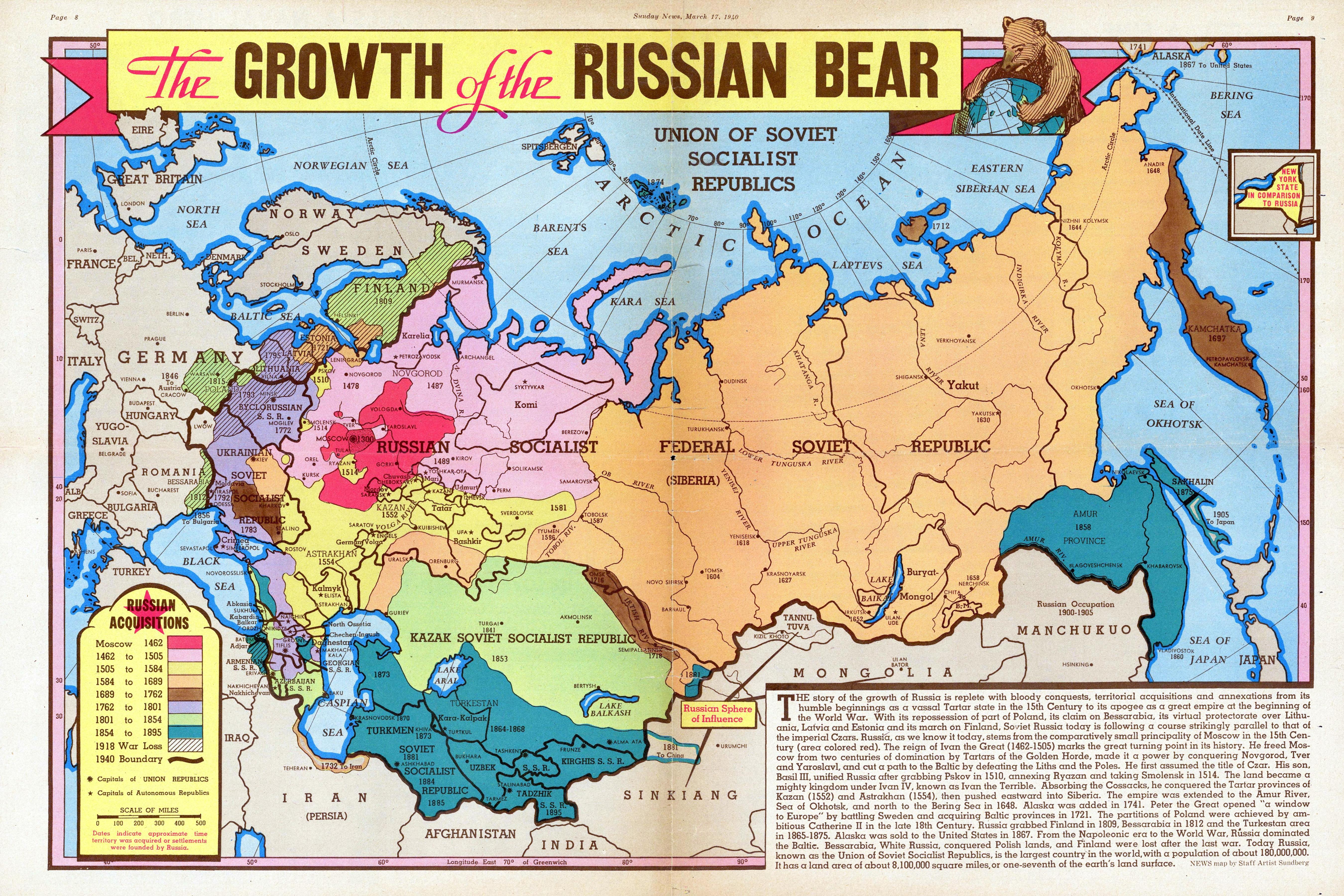
The "Growth of the Russian Bear" map from 1940 provides a detailed look at the territorial changes of Russia and the Soviet Union during a pivotal time in history. This visualization highlights both the expanse of the Soviet territory and the significant alterations that occurred before and during World War II. It showcases the vast areas that once formed the Soviet Union, reflecting a period of immense geopolitical shifts.
Transitioning from the map, we can delve deep into the historical and geographical context of Russia's territorial dynamics. This exploration helps us understand not just the borders, but also the underlying factors that influenced these changes.
Deep Dive into Territorial Changes
The territorial evolution of Russia and the Soviet Union has always been marked by conflict, expansion, and realignment. In the early 20th century, particularly after the Russian Revolution of 1917, the Soviet Union emerged as a significant power, seeking to consolidate its territory. By 1940, the USSR had expanded its borders considerably, incorporating various regions that today belong to multiple countries.
Interestingly, during this time, the Soviet Union was characterized by its diverse ethnic composition, with over 100 distinct nationalities. This ethnic diversity was both a strength and a challenge, as the government sought to unify these groups under a single socialist ideology while also managing local identities.
The map highlights key regions, including the Baltic States (Lithuania, Latvia, Estonia), which were annexed in 1940, and parts of Poland, which were divided between Nazi Germany and the USSR. This division was formalized in the Molotov-Ribbentrop Pact, a non-aggression treaty that surprisingly included secret protocols for territorial division. The incorporation of these areas into the Soviet sphere exemplified the expansionist policies of Stalin, who aimed to create a buffer zone of allied socialist states.
Moreover, the map captures the shifting borders in Eastern Europe, particularly after the Soviet invasion of Finland and the annexation of various territories in the Caucasus and Central Asia. The USSR's influence in these regions was profound, as it established numerous republics, each with unique cultural identities, while simultaneously promoting Russian culture and language.
In terms of statistics, the Soviet Union's territory expanded to cover approximately 22.4 million square kilometers by 1940, making it the largest nation in the world at the time. This size allowed for immense natural resources, agricultural land, and a strategic military presence, which were crucial during the tumultuous years of World War II.
Regional Analysis
Looking at the different regions depicted in the map, we can discern significant variations in population density, economic development, and cultural identity. For instance, the Baltic States had a predominantly ethnic population that largely resisted Soviet incorporation, leading to tensions that would last for decades. In contrast, Central Asian republics, such as Uzbekistan and Kazakhstan, experienced significant Soviet investment in infrastructure and industry, albeit at the cost of local autonomy.
The western regions, particularly Ukraine and Belarus, were crucial for the Soviet Union's agricultural output. Ukraine, often referred to as the “breadbasket” of Europe, played a vital role in supporting Soviet food production. However, the repercussions of Soviet policies, including collectivization and the Holodomor famine in the 1930s, left deep scars on the population and its cultural landscape.
Interestingly, while regions like Moscow and Leningrad (now St. Petersburg) thrived as political and cultural centers, many peripheral areas struggled with neglect and underdevelopment. This disparity in attention and resources has continued to influence regional identities and economies even after the dissolution of the USSR in 1991.
Significance and Impact
Understanding the territorial changes of Russia and the Soviet Union is crucial for comprehending current geopolitical tensions. The historical context provided by the 1940 map serves as a reminder of how borders can be influenced by ideology, conflict, and diplomacy. Today, many of the nations that emerged from the Soviet Union grapple with their identities, balancing their historical ties to Russia with their aspirations for independence and integration into the European community.
Furthermore, as we examine current trends, we see that Russia's ambitions continue to echo past territorial aspirations. The annexation of Crimea in 2014 and ongoing tensions in regions like Eastern Ukraine reflect a persistent desire for influence over former Soviet territories. This raises questions about the future of regional stability and the legacy of Soviet policies on modern-day geopolitics.
In conclusion, the "Growth of the Russian Bear" map is not just a historical artifact; it encapsulates the complexities of national identity, ethnic diversity, and the lasting impact of territorial changes. As we reflect on this map, it becomes evident that geography is not merely about lines on a page, but rather the lived experiences and histories of the people within those borders.
Visualization Details
- Published
- September 3, 2025
- Views
- 90
Comments
Loading comments...