Greco-Turkish War Map and Analysis

Marcus Rodriguez
Historical Geography Expert
Marcus Rodriguez specializes in historical cartography and geographic data analysis. With a background in both history and geography, he brings unique...
Geographic Analysis
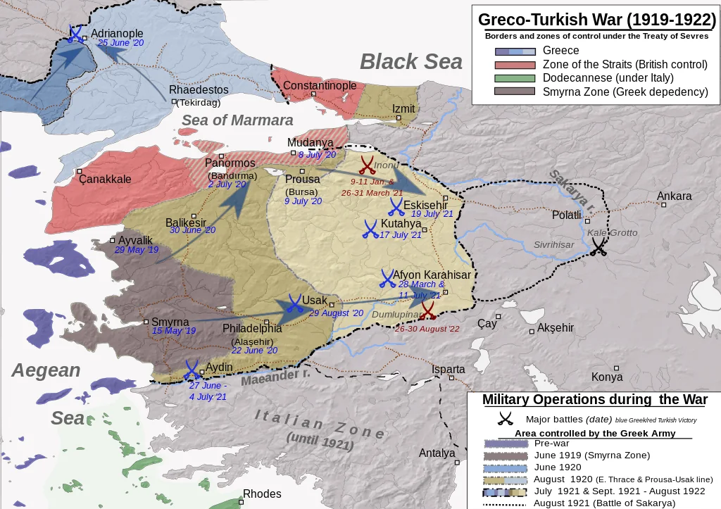
What This Map Shows
This map visualizes the geographical context of the Greco-Turkish War, highlighting key battle sites, territorial changes, and the socio-political landscape of the era. It provides an essential overview of the war's impact on the region, illustrating the complex dynamics between the Greek and Turkish forces, as well as the significant territories involved in the conflict.
Deep Dive into the Greco-Turkish War
The Greco-Turkish War, fought between 1919 and 1922, was a crucial conflict that stemmed from the aftermath of World War I and the collapse of the Ottoman Empire. This map not only depicts the battlefield locations but also emphasizes the broader geopolitical implications of the war. At the heart of this conflict was the ambition of Greece to expand its territory, particularly in Anatolia, an area rich with historical ties to Greek civilization.
Interestingly, the war marked a turning point in Turkish nationalism and the eventual establishment of the Republic of Turkey. The Greek forces, under the command of General Hacianestis, initially made significant advances into Anatolia. However, their campaign was characterized by a scorched-earth policy, which devastated numerous Turkish villages and towns, resulting in tens of thousands of civilian casualties. The brutal tactics employed during the retreat not only fueled animosity but also altered the demographic fabric of the region.
What’s fascinating is how the map delineates the shifting front lines, showcasing the Greek advances and subsequent Turkish counterattacks. The Turkish National Movement, led by Mustafa Kemal Atatürk, rallied to reclaim lost territories, culminating in a series of decisive victories that would ultimately lead to the Greek withdrawal. The war concluded with the Great Fire of Smyrna in 1922, a catastrophic event that resulted in immense destruction and loss of life, further complicating the already strained Greek-Turkish relations.
In a broader sense, the map serves as a testament to the war's legacy, which shaped national identities and territorial boundaries in the region. The aftermath of the conflict saw the signing of the Treaty of Lausanne in 1923, which formalized the borders of modern Turkey and led to significant population exchanges between Greece and Turkey.
Regional Analysis
Examining the map, we can see distinct regions where the war unfolded. The battle lines in Western Anatolia are particularly notable, as they illustrate the strategic importance of cities like Smyrna (Izmir) and Aydın. Smyrna, a bustling port city with a significant Greek population, became a focal point during the conflict. Its capture by Turkish forces marked a pivotal moment in the war, leading to widespread atrocities and the eventual displacement of Greeks.
In contrast, areas like Eastern Anatolia remained less impacted by the conflict, primarily due to their geographical barriers and the limited military engagement there. The regional differences highlight how terrain and urban centers influenced military strategies and outcomes. Furthermore, the map underscores the demographic shifts that occurred post-war; for instance, Western Anatolia saw a significant influx of Turkish populations following the Greek exodus.
Significance and Impact
Understanding the Greco-Turkish War's geographical implications is crucial for comprehending contemporary Greek-Turkish relations and regional politics. The war not only resulted in the establishment of modern Turkey but also set the stage for long-lasting ethnic tensions and territorial disputes. The conflict is a reminder of how historical grievances can shape national identities and influence international relations.
Today, as we reflect on the 103rd anniversary of Victory Day in Turkey, the significance of this conflict remains palpable. It serves as a crucial point of reference for discussions surrounding national sovereignty, historical narratives, and the complexities of post-imperial transitions in the Eastern Mediterranean. As Turkey continues to assert its influence in the region, understanding the historical context provided by this map is vital for anyone interested in the evolving dynamics of Greek-Turkish relations and their implications for regional stability.
Moreover, as we look to the future, the lessons learned from the Greco-Turkish War are relevant in the discussion of conflict resolution and peace-building efforts. How can nations reconcile their historical grievances while forging paths toward cooperation and mutual understanding? The map of the Greco-Turkish War encapsulates not just a moment in history, but also the ongoing dialogue about nationhood, identity, and the quest for peace in a historically fraught region.
Visualization Details
- Published
- August 31, 2025
- Views
- 58
Comments
Loading comments...