First European Settlement Map in Modern States

Alex Cartwright
Senior Cartographer & GIS Specialist
Alex Cartwright is a renowned cartographer and geographic information systems specialist with over 15 years of experience in spatial analysis and data...
Geographic Analysis
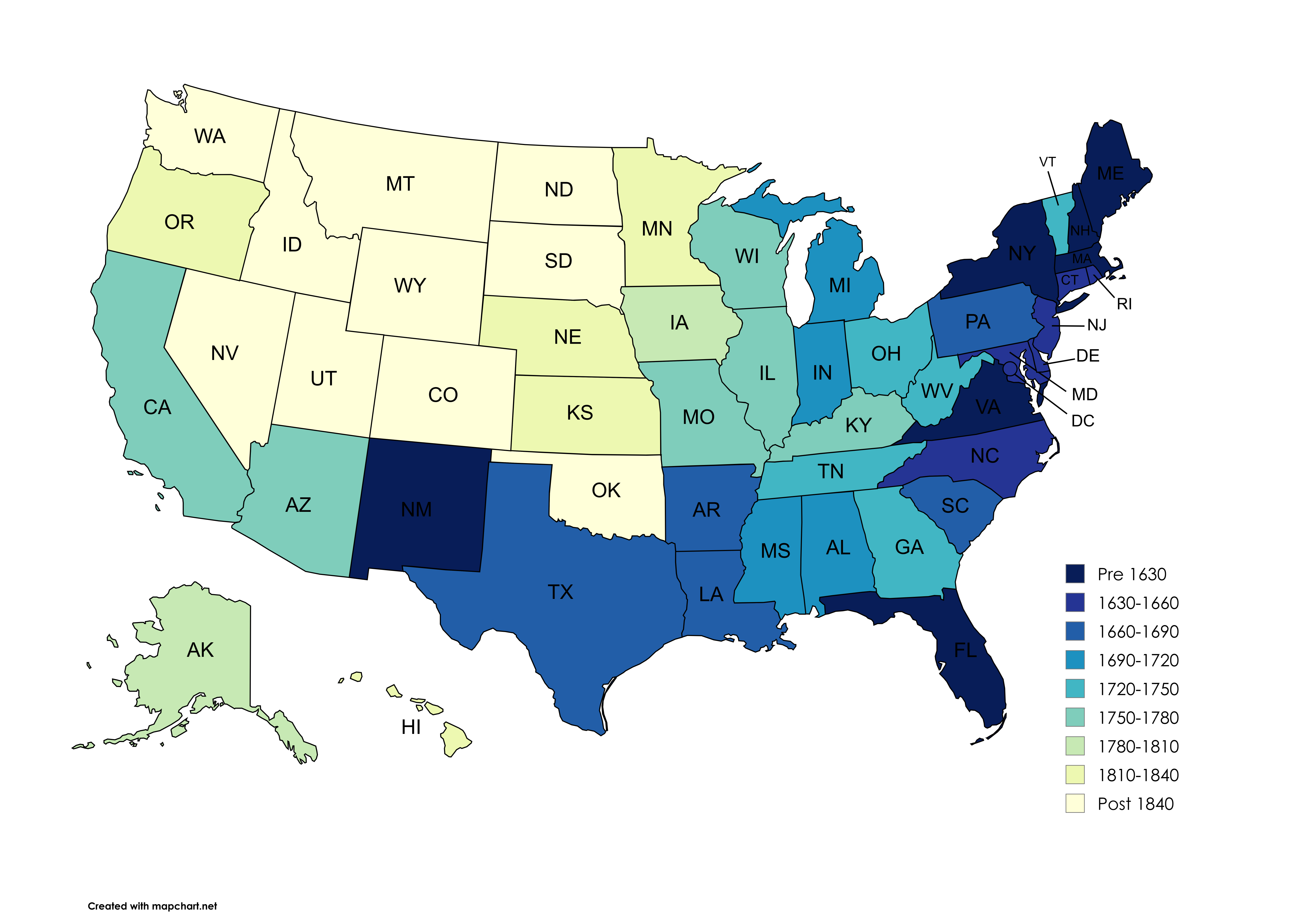
What This Map Shows
This map illustrates the time of first permanent European or European descendant settlement within the boundaries of modern-day states in the United States. Each state is color-coded to represent the year when the first settlement was established, from the early 16th century to the 19th century. This visualization not only highlights the geographical spread of European influence across North America but also provides insights into the historical context of colonization and westward expansion.
Deep Dive into European Settlement Patterns
The establishment of permanent settlements by Europeans in North America marked a significant turning point in the continent's history. Before European arrival, Indigenous peoples had been living on the land for thousands of years, developing rich cultures and societies. However, the arrival of European settlers initiated a profound transformation that would reshape the demographic, cultural, and political landscape of the continent.
Interestingly, the timeline of these settlements varied greatly across different regions. The earliest recorded European settlement was established in St. Augustine, Florida, by the Spanish in 1565. This event marked not just the beginning of European colonization in what is now the United States, but also the start of a long and complicated relationship between Indigenous populations and European settlers.
As we move into the 17th century, we see a flurry of activity along the eastern seaboard. The English established Jamestown, Virginia, in 1607, which became the first permanent English settlement in North America. This was followed by the founding of Plymouth Colony in 1620 by the Pilgrims. Each settlement brought with it different approaches to land use, governance, and relationships with Indigenous peoples.
During the 18th century, settlement patterns continued to evolve, particularly with the growth of colonies in New England, the Middle Colonies, and the Southern Colonies. The Dutch, for instance, established New Amsterdam (now New York City) in 1624, which became a hub of trade and cultural exchange.
As settlers moved westward, land claims and treaties with Native Americans became increasingly contentious. The drive for expansion often resulted in conflicts, leading to the forced removal of Indigenous peoples from their ancestral lands. The Louisiana Purchase in 1803 opened vast territories for settlement, leading to a surge of migration into what is now the Midwest and beyond. By the mid-19th century, settlements began to appear in states such as California and Oregon, driven by events like the Gold Rush and the promise of new opportunities.
The impact of these early settlements laid the foundation for the United States as we know it today. They shaped not only the demographic makeup of the nation but also its cultural and economic development. Understanding the timeline and location of these settlements helps us grasp the complexities of American history and the legacies that persist today.
Regional Analysis
Breaking down the map regionally reveals significant disparities in settlement timelines and patterns. For instance, in the Northeast, settlements occurred much earlier, with areas like Massachusetts and Virginia being among the first to see European presence. In contrast, states in the West, such as Nevada and California, were settled much later, primarily during the 19th century.
The Southeast saw early Spanish and French settlements, while the English dominated the Mid-Atlantic and New England regions. States such as Georgia were founded later as buffer colonies against Spanish Florida. Meanwhile, the Midwest was settled in waves, particularly driven by the promise of fertile land.
Interestingly, this map also highlights how some states have multiple settlement dates due to the diverse European influences—Spanish, French, Dutch, and English—each leaving their mark on the region's development. For example, Louisiana showcases a rich tapestry of French influence, while New York reflects a blend of Dutch and English heritage.
Significance and Impact
Understanding the timeline of European settlement is crucial for grasping the historical context of contemporary America. It highlights the often fraught interactions between settlers and Indigenous peoples, shedding light on issues of land rights and cultural preservation that are still relevant today.
Moreover, these early settlements set the stage for significant events such as the American Revolution and the westward expansion that followed. As we look toward the future, recognizing these historical patterns can inform discussions about immigration, cultural identity, and social justice in modern America. The legacy of these settlements continues to influence policies and societal norms, making it imperative to reflect on this complex history.
In summary, this map not only serves as a tool for visualizing the geographical spread of European settlement but also invites us to consider the profound effects these migrations had on the history and future of the United States. The timeline of first settlements remains a pivotal chapter in our understanding of American identity and cultural evolution.
Visualization Details
- Published
- August 29, 2025
- Views
- 84
Comments
Loading comments...