Map of Churches and Monasteries in Byzantine Israel

David Chen
Data Visualization Specialist
David Chen is an expert in transforming complex geographic datasets into compelling visual narratives. He combines his background in computer science ...
Geographic Analysis
What This Map Shows
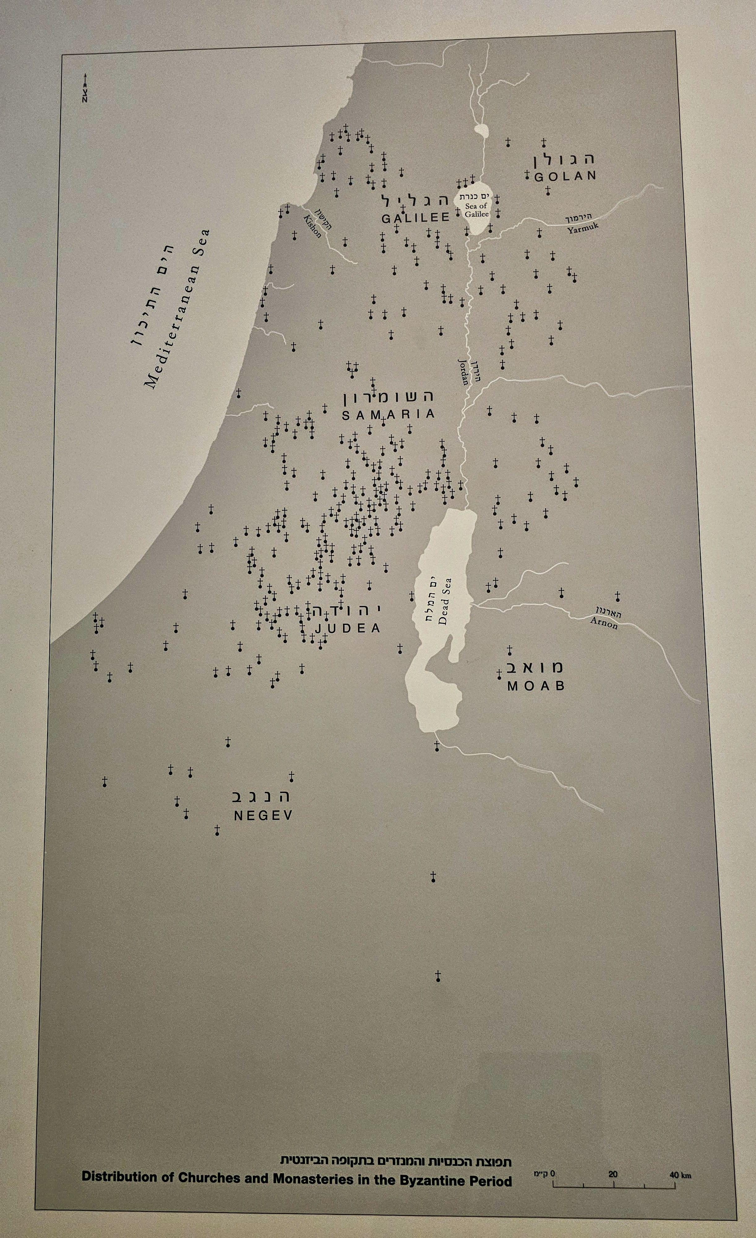
This map provides a detailed visualization of the distribution of churches and monasteries throughout the land of Israel during the Byzantine Period, approximately from 324 to 638 CE. The Byzantine Empire, known for its rich cultural and religious heritage, had a profound influence on the region, especially in terms of the spread of Christianity. The map clearly marks significant religious sites, highlighting both the density and geographic spread of these ecclesiastical structures across the varied landscapes of ancient Israel.
Transitioning from the visualization, let’s delve into the historical and cultural significance of these churches and monasteries, which serve as powerful testament to the Byzantine Era’s impact on the religious landscape of the region.
Deep Dive into Churches and Monasteries in Byzantine Israel
During the Byzantine Period, the land of Israel became a central hub for Christian pilgrimage and religious activity. The rise of Christianity as the state religion of the Roman Empire under Emperor Constantine the Great marked a turning point in the architectural and cultural development of the region. Churches and monasteries began to flourish, not only as places of worship but also as centers of community life and learning.
Interestingly, the architectural styles of these institutions varied, influenced by both local traditions and the broader Hellenistic and Roman building techniques. Basilicas became the predominant type of church structure, characterized by their elongated layout and large central nave flanked by aisles. This architectural choice was symbolic, representing the communal aspect of worship, where the congregation would gather to celebrate the Eucharist together.
Among the most significant sites were the Church of the Holy Sepulchre in Jerusalem, believed to be the location of Jesus’ crucifixion and resurrection, and the Monastery of St. Sabas near Bethlehem, established in the 5th century. These sites not only served local communities but also attracted pilgrims from across the Byzantine Empire and beyond, turning the region into a bustling center of religious activity.
The map indicates a concentration of these religious structures particularly around key urban centers such as Jerusalem, Bethlehem, and Nazareth. This clustering is not mere coincidence; it reflects the historical routes taken by pilgrims and the socio-political importance of these locales during the Byzantine rule. Furthermore, archaeological evidence suggests that many of these churches were built on older sites, often incorporating elements from earlier Jewish temples or Roman religious buildings, thus reflecting a continuity of sacred space.
Regional Analysis
Examining the distribution of churches and monasteries reveals intriguing regional variations. For instance, in Jerusalem, the concentration of religious buildings is particularly high. This city, revered as a holy place not only for Christians but also for Jews and Muslims, became the epicenter of Byzantine religious architecture. The presence of the Church of the Holy Sepulchre catalyzed the construction of additional churches, leading to a vibrant spiritual atmosphere.
In contrast, the Galilee region, while dotted with significant sites like the Church of the Beatitudes, reflects a less dense but equally important network of religious buildings. Here, the focus was on the life of Jesus and the early Christian community, leading to the establishment of churches that commemorate specific events from the New Testament.
On the other hand, the Negev Desert showcased a different pattern; monasteries such as the Monastery of St. Euthymius were established in remote areas, emphasizing ascetic lifestyles and the hermitic tradition that sought solitude and closeness to God. This regional diversity illustrates the multifaceted nature of Byzantine Christianity in Israel, each area contributing uniquely to the overall religious landscape.
Significance and Impact
The significance of this map extends beyond its visual representation of churches and monasteries. It encapsulates the transformative power of religion in shaping societal norms, cultural practices, and even architectural styles in Byzantine Israel. The proliferation of these religious sites during the Byzantine Period laid the groundwork for the continued importance of the region as a pilgrimage destination.
Today, the remnants of these ancient structures serve as vital links to understanding the history of Christianity and its evolution in this sacred land. They offer insights into the spiritual practices of early Christians and the formative years of the Church. Furthermore, current trends in tourism and heritage preservation highlight the ongoing relevance of these sites, as they attract visitors and scholars alike, eager to connect with the profound historical narratives that shaped not only the region but also the Christian faith as a whole.
In conclusion, the map of churches and monasteries in Byzantine Israel not only serves as a historical document but also as a reminder of the enduring legacy of faith, architecture, and community that continues to resonate in the land today.
Visualization Details
- Published
- August 28, 2025
- Views
- 90
Comments
Loading comments...