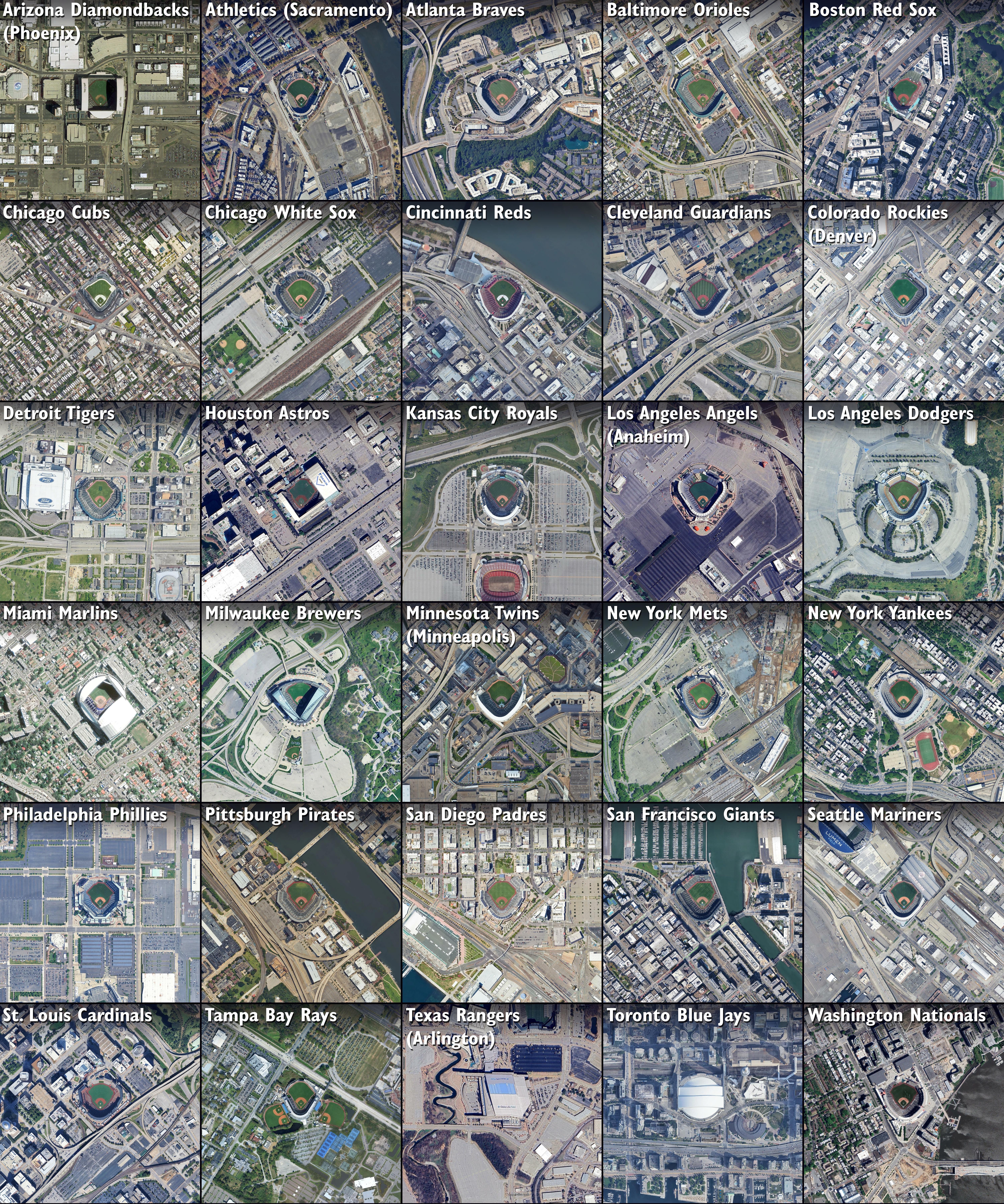
Land Use Map Around 30 MLB Stadiums


David Chen
Data Visualization Specialist
David Chen is an expert in transforming complex geographic datasets into compelling visual narratives. He combines his background in computer science ...
Geographic Analysis
What This Map Shows
This map presents satellite images illustrating land use around the 30 Major League Baseball (MLB) stadiums across the United States. By examining these images, we gain insight into how different urban environments are shaped not only by the stadiums themselves but also by the surrounding infrastructure, green spaces, and residential areas. Each stadium serves as a focal point in its respective city, and the land use patterns reveal much about urban planning, transportation, and community engagement.
Deep Dive into Land Use Patterns
When we think about land use, we’re actually diving into a complex tapestry of urban planning, zoning laws, and community needs. The land surrounding MLB stadiums varies dramatically from city to city, reflecting the unique attributes and demographics of each location. For instance, some stadiums are nestled in bustling urban centers, surrounded by high-rise buildings, restaurants, and shops, whereas others are positioned in more suburban areas, featuring open spaces and parking lots.
Interestingly, stadiums often act as catalysts for economic development. The presence of an MLB stadium can significantly influence local land use trends. In cities like San Francisco with Oracle Park or Chicago with Wrigley Field, these venues have spurred the development of commercial properties, housing, and public transportation systems. This phenomenon is particularly evident in cities where the stadium is a central part of the urban landscape, encouraging foot traffic and enhancing local businesses.
Moreover, the satellite imagery allows us to observe how green spaces are integrated into these urban settings. Parks and recreational areas often surround stadiums, providing residents and visitors alike with spaces for leisure, which is especially important in densely populated areas. For example, near Fenway Park in Boston, the nearby Commonwealth Mall provides a green respite amidst the urban hustle.
The geographical context also plays a crucial role in land use patterns. For instance, stadiums situated in coastal cities may incorporate waterfront areas, enhancing their scenic appeal, while those located in the Midwest may emphasize accessibility through extensive parking facilities. The land use map highlights these differences, revealing how geography can inform decisions about urban infrastructure and community planning.
Regional Analysis
Let’s break down the land use patterns surrounding the stadiums by region. In the Northeast, cities like New York and Boston showcase a blend of dense urban development alongside recreational spaces. Yankee Stadium and Fenway Park are prime examples where the land use is heavily influenced by the surrounding communities, which are characterized by a mix of residential and commercial zones.
Moving to the Midwest, we see a different dynamic. Stadiums like Wrigley Field in Chicago and Progressive Field in Cleveland are situated in neighborhoods that have undergone significant revitalization, with new businesses sprouting up and old ones adapting to the changing landscape. This revitalization often brings challenges, such as gentrification, which can alter the demographic makeup of the area.
In contrast, the West Coast exemplifies a more spacious approach to land use. At Oracle Park in San Francisco, the waterfront location provides ample opportunities for leisure and tourism, while the surrounding land has been developed with an emphasis on mixed-use spaces. Similarly, Dodger Stadium in Los Angeles, perched high in the hills, contrasts starkly with the urban sprawl below, emphasizing the need for transportation infrastructure to connect fans to games.
Significance and Impact
Understanding land use around MLB stadiums is essential for several reasons. Firstly, it allows city planners and policymakers to make informed decisions about urban development and public infrastructure. As cities continue to grow, balancing the needs of local businesses, residents, and sports fans becomes increasingly important.
Moreover, the economic impact of stadiums cannot be understated. They contribute significantly to local economies through job creation and tourism, but they also pose challenges, such as traffic congestion and noise pollution. As such, the land use map serves as a valuable tool for assessing these impacts and strategizing for sustainable urban development.
Currently, trends show that cities are increasingly prioritizing mixed-use developments that integrate commercial, residential, and recreational spaces. This approach not only enhances community engagement but also encourages a more sustainable lifestyle by minimizing the need for long commutes.
As we look to the future, it’s vital to consider how land use around MLB stadiums will evolve. Will we see more green spaces integrated into urban planning? How will changes in transportation infrastructure affect accessibility? These questions highlight the importance of continuously revisiting and analyzing land use patterns as cities adapt to changing demographics and environmental challenges.
Visualization Details
- Published
- August 23, 2025
- Views
- 174
Comments
Loading comments...