Spread of the Bubonic Plague in Europe Map

David Chen
Data Visualization Specialist
David Chen is an expert in transforming complex geographic datasets into compelling visual narratives. He combines his background in computer science ...
Geographic Analysis
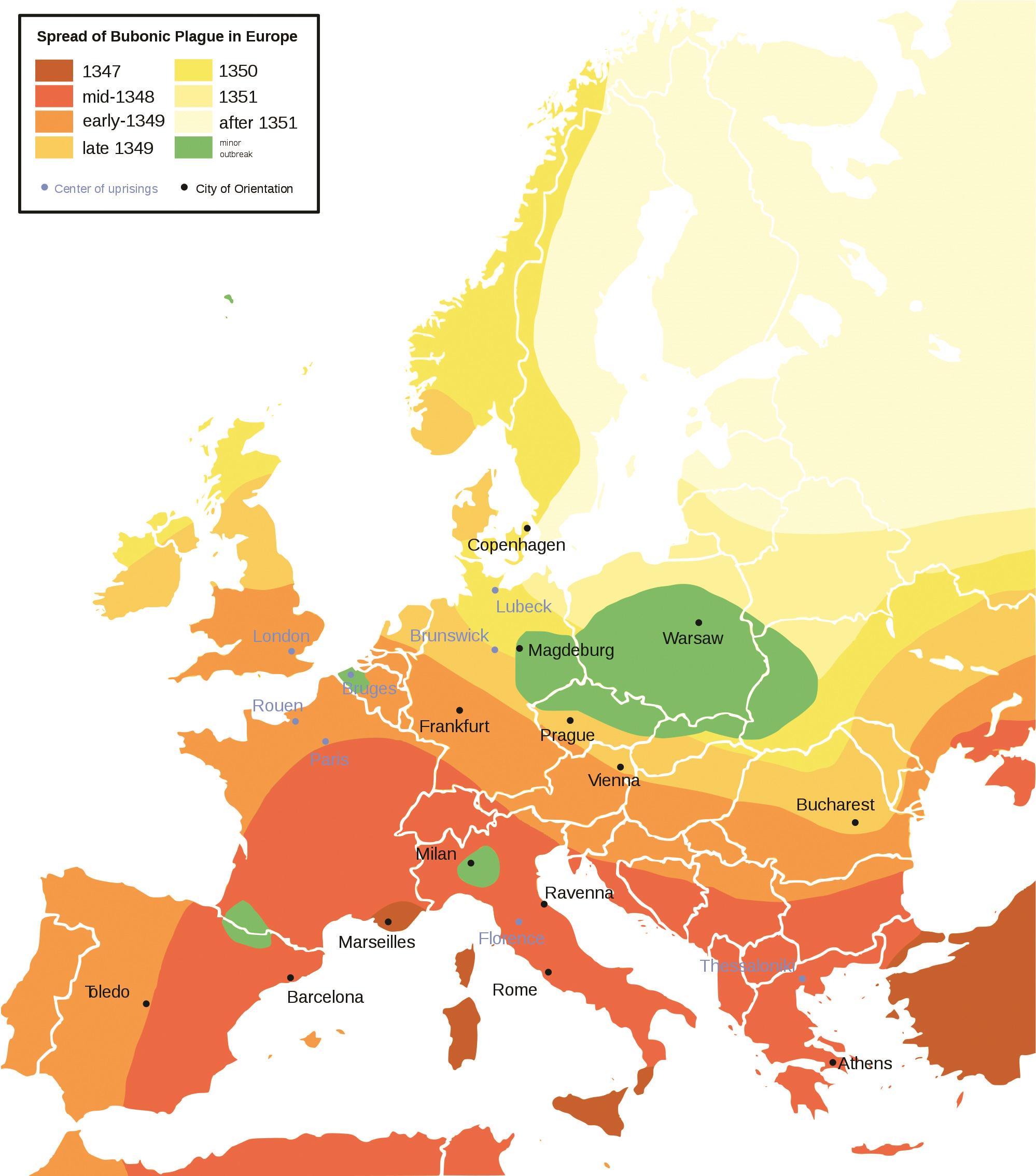
What This Map Shows
This map visually represents the spread of the Bubonic Plague across Europe during the 14th century, specifically highlighting its trajectory from its initial outbreak in the Black Sea region to its devastating impact in major cities such as Paris, London, and Venice. The visualization meticulously details the pathways taken by the plague, illustrating how it traversed various trade routes and urban centers, ultimately leading to one of the deadliest pandemics in human history. The focus here is not just on the geographic spread but also on how societal structures, trade, and environmental factors facilitated its rapid transmission.
Deep Dive into the Bubonic Plague
The Bubonic Plague, caused by the bacterium Yersinia pestis, is infamous for its catastrophic impact on Europe in the mid-14th century. What’s fascinating is that this disease didn’t merely spread randomly; it took advantage of the interconnectedness of medieval society, particularly through trade networks. The initial outbreak occurred in the early 1340s, and by 1347, the plague had reached the shores of Europe, carried by merchant ships that had docked in ports such as Messina, Sicily.
As the map indicates, the plague spread rapidly through key urban centers, largely because of the dense populations and unsanitary conditions prevalent in cities at the time. For instance, cities like Florence and Venice became hotspots for contagion, with their bustling markets and crowded living conditions creating an ideal environment for the disease to thrive. Historical records estimate that the Bubonic Plague claimed the lives of approximately 25 million people in Europe—around one-third of the continent's population at the time.
Interestingly, the symptoms of the plague were gruesome. Infected individuals suffered from fever, chills, and painful swellings called buboes, which gave the disease its name. The speed of the plague's spread was astonishing; it moved through Europe at a rate of around 20 to 30 miles per day, driven by a combination of human movement and the natural behavior of the fleas that carried the bacteria.
As we delve deeper into the societal impact, it’s important to note how the Bubonic Plague reshaped European history. The massive death toll led to labor shortages, which in turn initiated economic changes. Surviving workers could demand higher wages, leading to a gradual shift in the feudal system. The consequences of such a pandemic created an environment ripe for social and political transformation.
Regional Analysis
Looking at the map, we can see significant variations in the spread of the plague across different regions. Southern Europe, particularly Italy, was among the first to be hit, likely due to its strategic position as a trading hub. Cities like Genoa and Venice experienced severe outbreaks, with death rates soaring. In contrast, areas in Northern Europe, such as Norway and Sweden, faced a delayed impact, primarily due to their geographical isolation and less interconnected trade routes.
In central Europe, cities like Strasbourg and Frankfurt also reported high mortality rates, but they had varying responses to the crisis. For example, some regions implemented quarantine measures and travel restrictions to curb the spread, while others sank into chaos as fear and panic took hold. The map illustrates these differences, showcasing not just the spread of disease but also the varied societal responses across geographical boundaries.
Significance and Impact
The significance of understanding the spread of the Bubonic Plague goes beyond mere historical interest; it highlights the critical role of geography in public health. The pandemic serves as a stark reminder of how interconnected our world is and how diseases can exploit these connections. Today, as we face global health challenges, the lessons learned from the Bubonic Plague are more relevant than ever.
As we analyze the past, we must consider current trends in global travel and trade, which can facilitate the rapid spread of diseases. Have you noticed how modern pandemics, like COVID-19, followed similar patterns of spread across densely populated urban centers? The historical context provided by the Bubonic Plague can help us better prepare for future outbreaks and understand the implications of our globalized world.
In conclusion, the map of the Bubonic Plague’s spread in Europe not only documents a tragic chapter in human history but also serves as a crucial tool for understanding the interplay between geography, society, and disease. As we continue to grapple with health crises today, reflecting on the past can provide valuable insights into how to navigate future challenges.
Visualization Details
- Published
- August 22, 2025
- Views
- 164
Comments
Loading comments...