Rock Map of Crete

David Chen
Data Visualization Specialist
David Chen is an expert in transforming complex geographic datasets into compelling visual narratives. He combines his background in computer science ...
Geographic Analysis
What This Map Shows
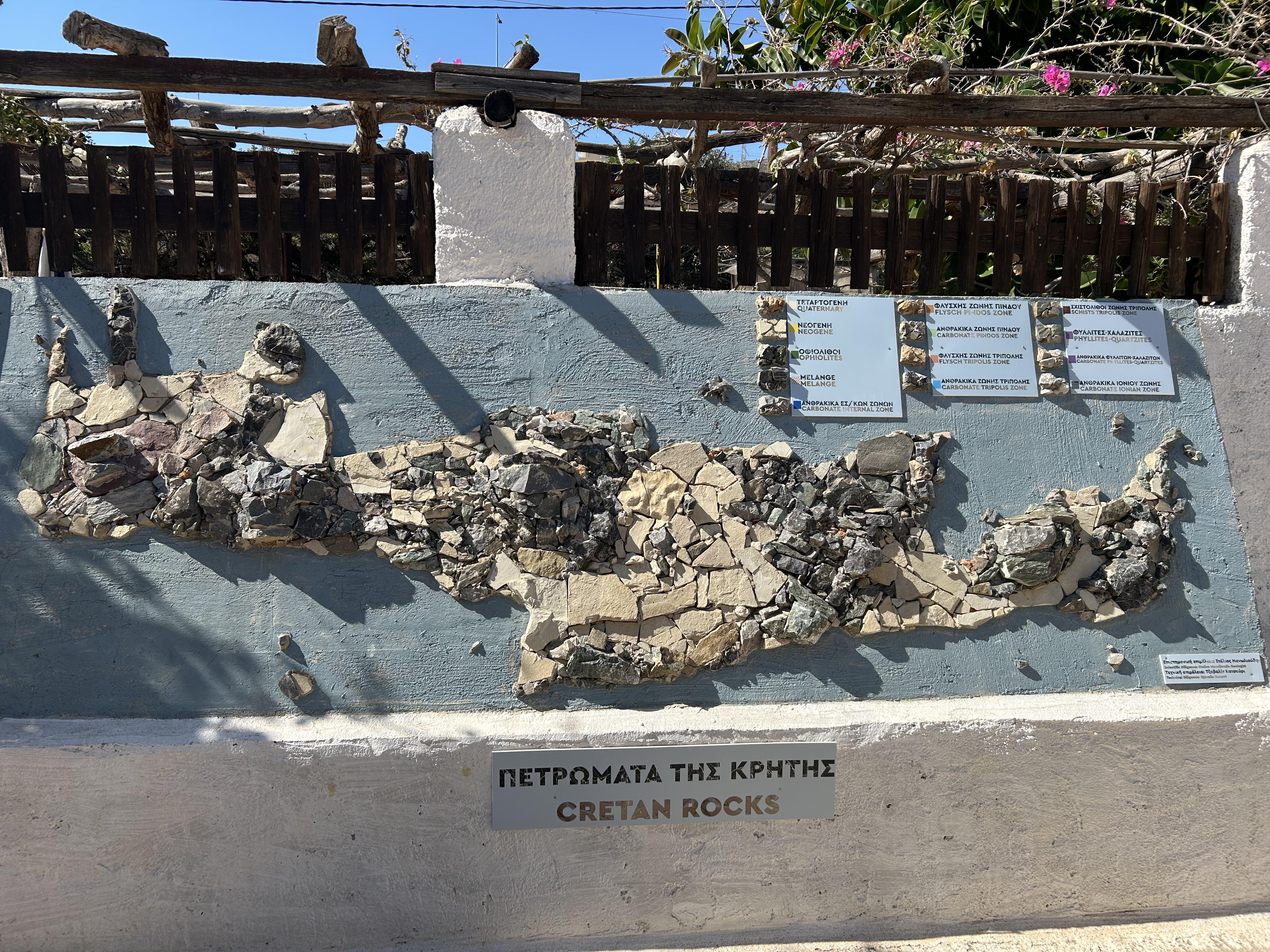
The Rock Map of Crete, located at the Lychnostatis Open Air Museum in Limenas Chersonisou, provides a detailed representation of the diverse geological formations found on the island. This map is not just a visual guide; it serves as a powerful educational tool that highlights the unique rock types, their distributions, and the geological history of Crete. By depicting various rock formations, the map helps visitors understand how these geological features have shaped both the landscape and the culture of the island.
Deep Dive into Crete's Geology
Crete is a geological wonderland, characterized by its complex rock formations that date back millions of years. The island's geology is primarily composed of limestone, dolostone, and other sedimentary rocks, alongside igneous and metamorphic formations. Interestingly, the rock types present on Crete are a result of tectonic activities, sediment deposition, and erosion over time, making it a fascinating case study for geologists.
One of the most common rock types on the island is the limestone, which forms the backbone of Crete’s mountainous regions. This limestone is known for its karstic features, including caves, sinkholes, and unique topography. For example, the White Mountains (Lefka Ori) and the Dikti Mountains are predominantly composed of limestone, offering breathtaking landscapes that attract hikers and nature lovers alike.
However, Crete is not just about limestone. The island also boasts significant deposits of schist and marble, particularly in the eastern and central regions. Schist is a metamorphic rock that forms under high temperature and pressure, contributing to the rugged terrain of the island. In contrast, the presence of marble, especially in areas like the village of Tylissos, speaks to the island’s rich history of stone quarrying and its influence on local architecture.
The geological history of Crete is intricately linked to the island's positioning on the boundary between the African and Eurasian tectonic plates. This positioning has resulted in significant geological activity, including earthquakes and the uplift of landmasses. For example, the formation of the Samaria Gorge, one of Crete's most famous natural attractions, is a direct result of erosional processes acting on the region's geology.
What's fascinating is that the geological diversity of Crete not only shapes its physical landscape but also supports a rich biodiversity. The various rock types contribute to different soil compositions, which in turn influence the types of vegetation that thrive in each region. This interplay between geology and ecology is vital for understanding the island’s natural heritage.
Regional Analysis
Breaking down the rock formations by specific regions offers insight into the geological diversity across Crete. For instance, the western part of Crete is dominated by the White Mountains, where limestone cliffs rise dramatically, creating a distinct landscape. The area around Chania is particularly known for its rugged terrain and deep gorges, making it a hotspot for geological study and tourism.
In contrast, the eastern region, including towns like Agios Nikolaos, showcases a different geological profile. Here, the presence of volcanic rocks and more recent sedimentary deposits indicates a dynamic geological history that differs from the older formations found in the west. The variety of rock types leads to different soil characteristics, which can be observed in the agricultural practices of the region.
Moreover, the southern coast of Crete features a mix of limestone and sandstone, creating unique coastal cliffs and coves. Places like Matala, known for its historical caves, illustrate how the geological processes have not only shaped the landscape but also influenced human settlement and cultural practices over millennia.
Significance and Impact
Understanding the geology of Crete is crucial for several reasons. Firstly, it has significant implications for environmental conservation. The diverse rock formations and ecosystems contribute to the island's biodiversity, making it essential to protect these geological features from erosion and human activity.
Furthermore, the geological history of Crete sheds light on broader tectonic processes that affect regions around the Mediterranean. By studying these formations, scientists and geologists can better understand seismic risks and environmental changes that may impact local communities.
In recent years, there has been a growing interest in sustainable tourism that focuses on the natural and geological heritage of areas like Crete. By promoting awareness of the island's unique geological features, stakeholders can encourage responsible tourism practices that benefit both the environment and the local economy.
In conclusion, the Rock Map of Crete serves as a vital educational resource that deepens our understanding of the island’s geological landscape. It highlights not only the beauty of Crete's natural formations but also their significance in shaping the island's culture, economy, and biodiversity. As we continue to explore and learn about these rock types, we gain a greater appreciation for the intricate relationship between geology and human life on this enchanting island.
Visualization Details
- Published
- August 19, 2025
- Views
- 120
Comments
Loading comments...