Map of English Plantations in Ireland 16th 17th Century

Marcus Rodriguez
Historical Geography Expert
Marcus Rodriguez specializes in historical cartography and geographic data analysis. With a background in both history and geography, he brings unique...
Geographic Analysis
What This Map Shows
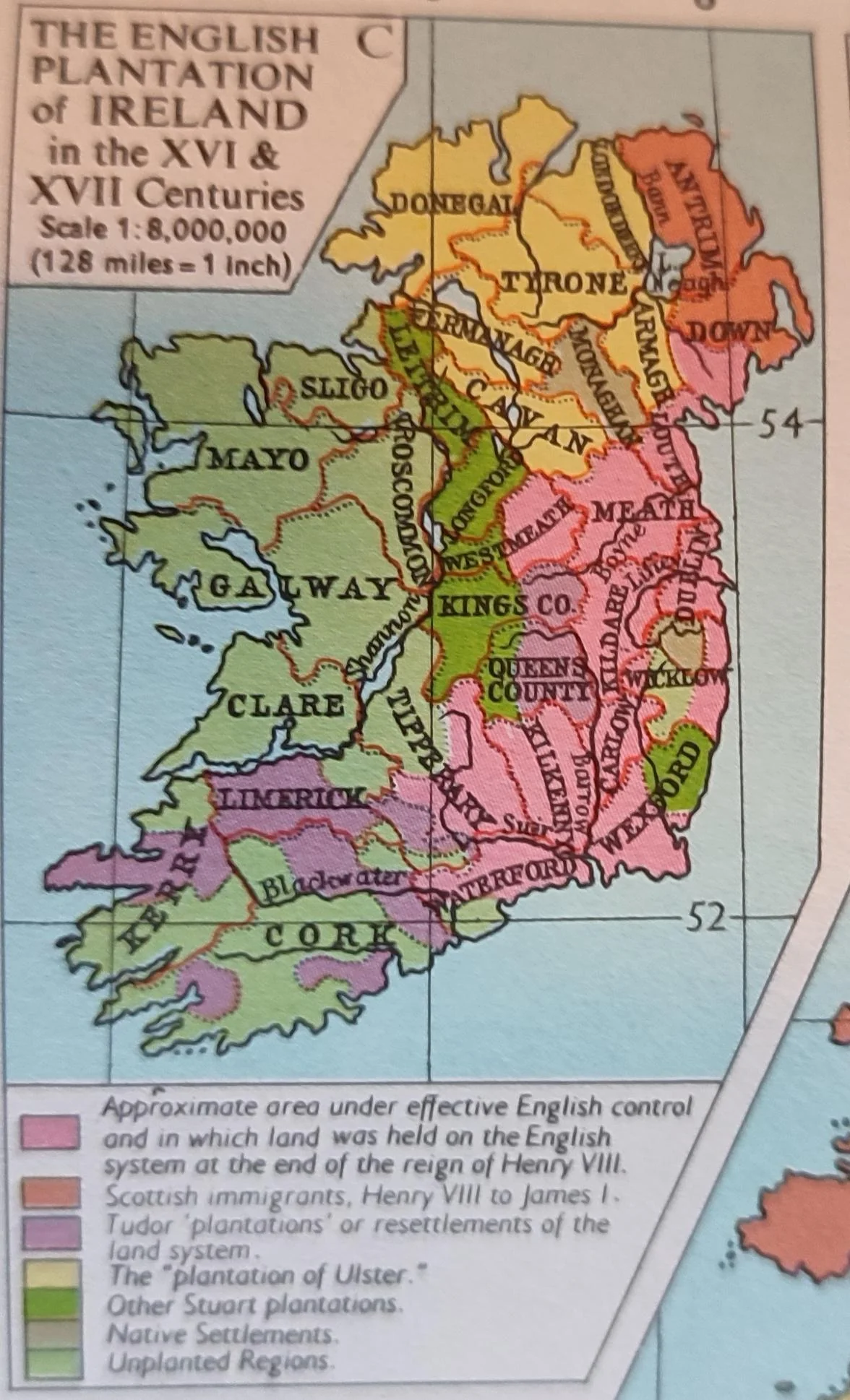
The map titled "The English Plantation in Ireland in the 16th & 17th Century" illustrates a significant historical period marked by English colonization efforts in Ireland. It highlights the locations of English settlements, land distribution, and the socio-political landscape of Ireland during this time. This map serves as a visual representation of how English authority sought to control and influence the Irish landscape through the establishment of plantations, which were often accompanied by the displacement of indigenous populations.
Deep Dive into English Plantations in Ireland
The English plantations in Ireland were a series of colonization projects initiated primarily in the 16th and 17th centuries. The driving force behind these plantations was the English Crown's desire to extend its influence and control over Ireland, seen as a land ripe for settlement and exploitation. The process began in earnest after the Tudor conquest of Ireland and continued through the subsequent Stuart period.
Interestingly, the plantations were not merely about settling English people in Ireland; they involved a systematic approach to land confiscation. Large tracts of land were taken from Irish nobility and given to English settlers. The most notable plantations were in areas like Ulster, Munster, and Connacht, where the English established their governance structures and agricultural practices.
One of the most significant plantations was the Ulster Plantation, initiated in the early 1600s. It involved the settlement of thousands of Scottish Presbyterians, alongside English settlers, in what is now Northern Ireland. This project was not only about land but also about planting a new culture and religion, as the settlers were primarily Protestant, contrasting sharply with the predominantly Catholic Irish population. In fact, by 1641, the Protestant population in Ulster had increased dramatically, changing the demographic landscape of the region.
The economic implications of these plantations were profound. The English settlers introduced new agricultural practices, including the cultivation of crops like flax and the rearing of sheep for wool production. These changes altered the traditional Irish agrarian economy, making it more export-oriented and commercially viable but also leading to the marginalization of Irish farmers. Have you noticed how such agricultural shifts can impact local economies? In Ireland, the economic benefits accrued primarily to the English settlers, often at the expense of the native Irish populace, who faced displacement and loss of livelihood.
Furthermore, the social fabric of Ireland was irrevocably altered. The plantations created communities that were often hostile to the native Irish, leading to tensions and conflicts that would echo throughout Irish history. This period saw the establishment of a Protestant ascendancy that would dominate Irish politics and society for centuries, leading to a legacy of division that still resonates today.
Regional Analysis
When we examine the map closely, we see distinct variations in how the plantations were established across different regions. In Munster, for example, the plantations were characterized by the creation of large estates, often held by English aristocrats who would employ Irish tenants. This contrasts sharply with Ulster, where the settlement was more focused on creating new towns and communities that were predominantly English or Scottish. These regional differences highlight how the English approach to colonization was not uniform but rather adapted to local conditions and existing power dynamics.
In Connacht, the situation was somewhat different as the English Crown attempted to consolidate control over this less populated region. The map shows fewer plantations here compared to Ulster and Munster, reflecting the Crown's challenges in establishing a foothold. The resistance from local Gaelic lords was more pronounced in Connacht, making it harder for the English to exert control. This regional analysis showcases the complexities and challenges faced by the Crown in their colonization efforts, as well as the varied responses from the Irish populace.
Significance and Impact
The significance of the English plantations in Ireland cannot be overstated. They represent a crucial turning point in Irish history, laying the groundwork for centuries of conflict and division. The socio-political ramifications of these plantations are still evident today, as historical grievances linger in the collective memory of the Irish people. The map serves as a reminder of how colonial practices can reshape societies and create lasting divides.
Moreover, understanding this period gives us insight into current discussions around land rights and cultural identity in Ireland. The legacy of plantation policies is still felt, as debates around land ownership and community rights continue to resonate in modern Ireland. As we look to the future, it's crucial to consider how these historical injustices inform contemporary policies and community relations. Ever wondered why discussions about land and identity are so central to modern Irish politics? The roots of these conversations stretch back to the very heart of the English plantation efforts in the 16th and 17th centuries.
In conclusion, the map of English plantations in Ireland during the 16th and 17th centuries is not just a historical artifact; it is a testament to the complexities of colonization and its lasting impact on a nation. The lessons learned from this period are vital for understanding contemporary issues in Ireland and beyond.
Visualization Details
- Published
- August 18, 2025
- Views
- 118
Comments
Loading comments...