Map of the Old River Control Structure in Louisiana

Alex Cartwright
Senior Cartographer & GIS Specialist
Alex Cartwright is a renowned cartographer and geographic information systems specialist with over 15 years of experience in spatial analysis and data...
Geographic Analysis
What This Map Shows
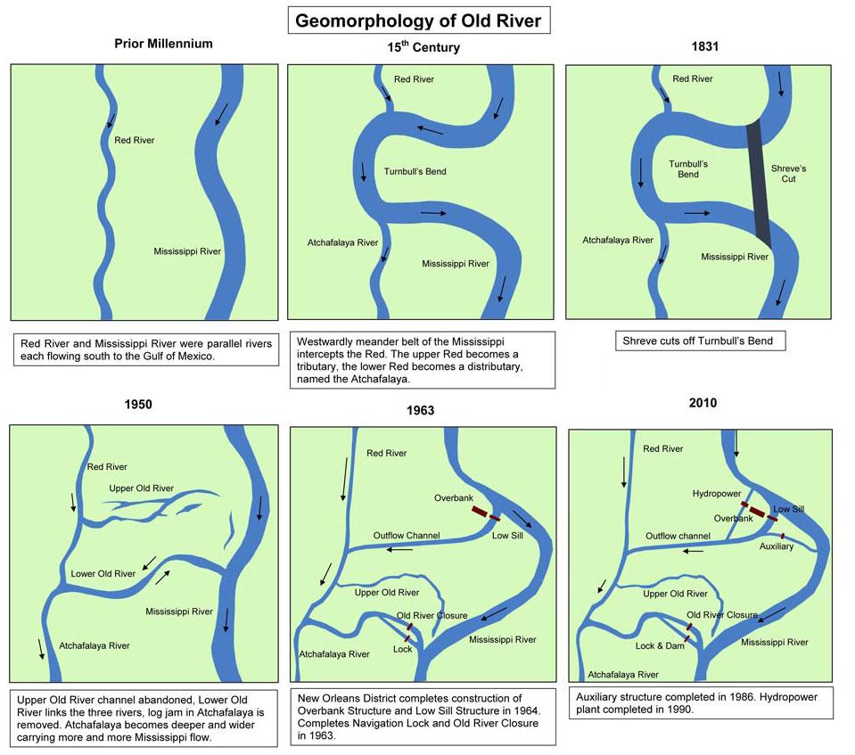
The map of the Old River Control Structure provides a clear visual representation of a crucial engineering feat located in Louisiana. This structure is designed to manage the flow of the Mississippi River and prevent its diversion into the Atchafalaya River, a situation that could have significant ecological and economic consequences. By using this map, viewers can grasp the strategic importance of the control structure, its positioning, and how it interacts with the surrounding waterways.
Deep Dive into River Systems
Rivers are not just natural waterways; they are lifelines for ecosystems and human societies. The Mississippi River, one of the longest rivers in the United States, runs approximately 2,340 miles from its source at Lake Itasca in Minnesota to the Gulf of Mexico. It collects water from a vast watershed covering about 1.2 million square miles, making it one of the most significant river systems in North America.
Interestingly, the Mississippi River historically has shown a tendency to change its course due to sediment deposition and erosion. This is where the Old River Control Structure comes into play. Built in the 1960s, this system of gates and levees was engineered to ensure that a significant portion of the Mississippi's flow remains directed down its main channel, thereby reducing the risk of the river permanently diverting into the Atchafalaya River, which is its natural floodplain.
The Atchafalaya River is the primary distributary of the Mississippi River and has been experiencing an increase in flow over the decades. Without the Old River Control Structure, hydraulic modeling suggests that the Atchafalaya could eventually capture an overwhelming portion of the Mississippi’s flow, leading to ecological shifts and significant impacts on the communities relying on the Mississippi River for transport, water supply, and recreation.
The Old River Control Structure consists of several components, including a control structure and spillway, which work together to regulate the water levels and flow rates of both rivers. This is vital not only for human activity but also for the diverse ecosystems that depend on these waterways. The structure is a remarkable example of human intervention designed to maintain the natural balance of river systems, illustrating the intricate relationship between human engineering and natural processes.
Regional Analysis
When examining the regions shown on the map, it's crucial to consider the ecological and economic implications of the Old River Control Structure. For instance, the lower Mississippi River Delta, where the river meets the Gulf of Mexico, is one of the most biodiverse areas in the United States. This region supports various wildlife habitats, including wetlands that are critical for flood protection and water filtration.
Conversely, the Atchafalaya Basin, which is home to unique ecosystems, has been affected by the river’s changing dynamics. In fact, the Atchafalaya Basin has been experiencing increased sediment deposition due to the diversion of water, which can lead to habitat loss and disruption of local fishing industries.
Furthermore, the economic activities in the region vary significantly. The Mississippi River remains a crucial transportation route for goods, while the Atchafalaya Basin supports local fisheries and recreational activities. Comparing these two areas reveals stark differences in how communities interact with their waterways and the resources they depend upon. The control structure not only safeguards the economic interests tied to the Mississippi but also plays a role in the environmental stability of the Atchafalaya Basin.
Significance and Impact
The Old River Control Structure is not just an engineering marvel; it has profound implications for both the environment and the economy. Its existence helps maintain the flow of the Mississippi, which is vital for navigation, agriculture, and water supply for millions of people. Have you ever wondered why maintaining river flow is so critical? It’s because any sudden shift could lead to devastating floods or droughts, impacting agricultural production and water availability for households and businesses alike.
What’s fascinating is that this structure also serves as a case study for modern river management and conservation strategies. As climate change continues to alter weather patterns and river behaviors, the lessons learned from the Old River Control Structure may inform future projects aimed at balancing human needs with ecological sustainability. The ongoing monitoring and adjustments made to the structure are essential to adapt to these changes, ensuring that both the Mississippi and Atchafalaya rivers can coexist harmoniously.
In conclusion, the map of the Old River Control Structure not only offers a geographical perspective but also invites us to consider the intricate relationships between human engineering, natural ecosystems, and the communities that thrive along these vital waterways. As we move forward, understanding these dynamics will be key to managing our water resources wisely, ensuring a sustainable future for generations to come.
Visualization Details
- Published
- August 16, 2025
- Views
- 122
Comments
Loading comments...