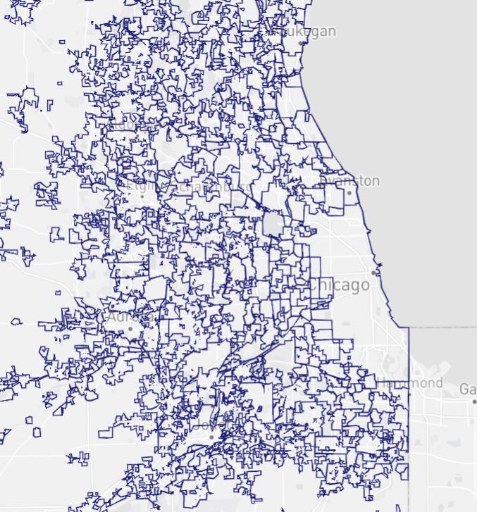
Chicago Metro City Boundaries Map

David Chen
Data Visualization Specialist
David Chen is an expert in transforming complex geographic datasets into compelling visual narratives. He combines his background in computer science ...
Geographic Analysis
What This Map Shows
The "Chicago Metro City Boundaries Map" provides a striking visual representation of the various city boundaries within the Chicago metropolitan area. At first glance, one might be taken aback by the irregular shapes and lines that delineate neighborhoods, towns, and cities throughout the region. This map not only highlights the complexity of urban development in the Chicago area but also serves as a gateway to understanding the historical and socio-political factors that have contributed to such distinct boundaries.
Deep Dive into Chicago's City Boundaries
The city boundaries in the Chicago metropolitan area are a fascinating study in urban geography. Chicago itself is a sprawling metropolis, but the surrounding suburbs and municipalities have their own unique identities, often defined by quirky and sometimes nonsensical boundaries. Have you ever wondered why some neighborhoods seem to abruptly end and transition into different towns? This phenomenon is largely due to historical annexations, local governance decisions, and socio-economic factors.
Interestingly, the historical context plays a significant role in the formation of these boundaries. Chicago, founded in 1837, rapidly grew in the late 19th and early 20th centuries as a hub for transportation and industry. During this period, many surrounding areas were incorporated as separate municipalities. For example, the city of Evanston, located just north of Chicago, was established as a distinct entity in 1857, primarily to serve the needs of Northwestern University students and residents seeking a suburban lifestyle. This trend of suburbanization continued throughout the 20th century, resulting in a patchwork of municipalities with their own governing bodies and regulations.
Another factor contributing to the unusual boundaries is the influence of zoning laws and local governance. Each municipality has its own set of rules governing land use, development, and community services. This leads to discrepancies in city sizes and shapes. For instance, the city of Oak Park has a unique boundary that is almost entirely surrounded by the city of Chicago. These boundaries are influenced by historical land ownership, community planning efforts, and even geographical features like rivers and railways.
Demographics also play a crucial role in shaping city boundaries. As populations shift and change, municipalities may alter their boundaries to better reflect the needs and desires of residents. This can lead to the annexation of unincorporated areas, or even the creation of new municipalities in response to urban sprawl. For example, the city of Naperville has seen tremendous growth over the past few decades, leading to an expansion of its borders to accommodate new housing developments and commercial centers.
Regional Analysis
When analyzing the Chicago Metro area, it becomes evident that different regions have their own unique characteristics. The northern suburbs, such as Skokie and Wilmette, are primarily residential and tend to have more affluent populations. In contrast, the southwestern suburbs, including Oak Lawn and Orland Park, have a more diverse demographic makeup and a mix of residential and commercial spaces. Interestingly, the boundaries of these municipalities reflect their historical development patterns and the socio-economic status of their residents.
For example, the boundary of Chicago itself is quite convoluted, with some areas extending far into the suburbs. This is partly due to historical annexations that expanded the city's reach. Meanwhile, the border between Chicago and its neighboring suburbs often creates a stark contrast in community resources, services, and overall quality of life. A resident of Chicago might notice a significant difference in public services and amenities compared to those living just a few blocks away in a suburb like Cicero or Berwyn.
Significance and Impact
Understanding the unique city boundaries within the Chicago Metro area is crucial for several reasons. Firstly, these boundaries have direct implications for governance, resource allocation, and community services. With different municipalities having varying budgets and tax structures, residents may experience different levels of public services, such as education, policing, and infrastructure maintenance.
Furthermore, the historical context of these boundaries sheds light on broader trends in urban development and socio-economic divides. The distinct edges of cities can highlight segregation patterns, economic disparity, and varying access to resources. This is especially relevant today as urban planners and policymakers work to address issues of inequality and promote more inclusive growth.
What's fascinating is that, as the Chicago Metro continues to evolve, the conversation around city boundaries is becoming more relevant. With ongoing discussions about affordable housing, transportation, and urban sprawl, understanding these boundaries can inform better policy decisions and community planning efforts. As the population grows and changes, so too will the conversations surrounding what these boundaries mean for the future of Chicago and its surrounding metro area.
Visualization Details
- Published
- August 15, 2025
- Views
- 130
Comments
Loading comments...