Southeast Asia Historical Map 1792-1860

Marcus Rodriguez
Historical Geography Expert
Marcus Rodriguez specializes in historical cartography and geographic data analysis. With a background in both history and geography, he brings unique...
Geographic Analysis
What This Map Shows
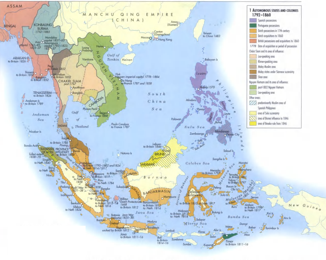
The "Southeast Asia 1792-1860" map offers an intriguing glimpse into a region that has undergone significant transformation over the centuries. It captures the political boundaries, trade routes, and geopolitical influences during a period marked by colonial expansion and regional conflict. This visualization not only highlights the geographic features of Southeast Asia but also serves as a historical record of the nations and empires that were prominent at the time.
Interestingly, during this era, Southeast Asia was a melting pot of cultures, languages, and influences, shaped by both indigenous peoples and external forces. The map illustrates how the region was divided among various colonial powers, including the British, Dutch, and Spanish, each vying for control over trade routes and resources.
Deep Dive into Colonial Influence and Trade
The period from 1792 to 1860 was pivotal for Southeast Asia, primarily due to the increasing influence of European colonial powers. By the late 18th century, the British had established a presence in the Malay Peninsula, with key trading posts in places like Penang and Singapore. The Dutch, on the other hand, had solidified their control over the Indonesian archipelago, primarily through the Dutch East India Company, which dominated the spice trade.
This era was characterized by the rise of cash crop economies, particularly the production of commodities such as sugar, rubber, and coffee. The cultivation of these crops required significant labor, leading to various forms of labor exploitation, including the use of indentured servitude and slave labor. Have you ever wondered why certain crops became staples in global trade? The geographical conditions in Southeast Asia, with its fertile volcanic soil and tropical climate, provided a perfect environment for these crops to flourish.
Furthermore, the map illustrates important trade routes that connected Southeast Asia with Europe, China, and India. The Straits of Malacca, for example, emerged as one of the world's busiest maritime routes, facilitating not just trade but also cultural exchanges. This heightened connectivity allowed for the spread of ideas, technologies, and religions, including Islam and Buddhism, which have had lasting impacts on the region's cultural landscape.
Regional Analysis
Looking more closely at the regions depicted in the map, we can observe distinct patterns of colonial influence and economic activity. For instance, in present-day Vietnam, the French began to establish their control during this period, leading to significant changes in agricultural practices and local governance. The impact of French colonialism is still evident today in the architecture, language, and culinary traditions of Vietnam.
Conversely, the Philippines, colonized by the Spanish, experienced a different trajectory. The Spanish introduced Catholicism, which transformed the religious landscape of the archipelago, making it one of the most predominantly Catholic countries in Asia today. The interplay of local resistance and colonial rule shaped the sociopolitical dynamics of these islands, leading to revolts and eventual movements for independence.
While regions like Java and Sumatra became centers for the Dutch’s extraction of natural resources, the interior parts of Borneo and Mindanao remained less affected by direct colonial rule for longer periods. This led to a patchwork of influences across the archipelago, with some areas retaining more of their indigenous cultures compared to others heavily influenced by European powers.
Significance and Impact
Understanding the historical context of Southeast Asia from 1792 to 1860 is crucial for appreciating the complexities of the region today. The legacies of colonialism are still palpable, impacting political boundaries, cultural identities, and economic structures. For instance, the borders drawn during this time often disregarded ethnic and cultural divisions, leading to tensions that can still be observed in contemporary conflicts.
Moreover, the shift towards cash crop economies during this period laid the groundwork for the region's current agricultural practices and economic dependencies. As Southeast Asia continues to play a significant role in global trade, reflecting on its historical trade routes and colonial past offers valuable insights into its future trajectory.
What’s truly fascinating is how the map from 1792-1860 encapsulates not just a moment in time, but also the enduring influences that continue to shape Southeast Asia's rich tapestry of cultures and economies. As we move forward, understanding these historical dynamics becomes ever more important in addressing the contemporary challenges faced by these nations today.
Visualization Details
- Published
- August 14, 2025
- Views
- 72
Comments
Loading comments...