Typhoon Podul Atmospheric Map Over Taiwan and South China

Marcus Rodriguez
Historical Geography Expert
Marcus Rodriguez specializes in historical cartography and geographic data analysis. With a background in both history and geography, he brings unique...
Geographic Analysis
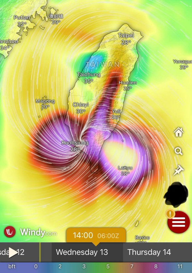
What This Map Shows\nThe atmospheric map of Typhoon Podul currently crossing over Taiwan and South China provides a visual representation of the storm's intensity, wind patterns, and projected trajectory. This map is crucial for understanding the impact of Podul as it interacts with the geographical features of the region, particularly the mountainous terrain of Taiwan and the coastal areas of southern China. Typhoons are complex meteorological phenomena, and such visualizations help in predicting their behavior and potential effects on populated areas.
Deep Dive into Typhoons\nTyphoons, known as tropical cyclones in other parts of the world, are powerful storms characterized by strong winds, heavy rainfall, and the potential for significant flooding. These storms form over warm ocean waters, typically between 5° and 20° latitude, where sea surface temperatures exceed 26 degrees Celsius. The energy derived from the warm ocean fuels the storm's development. Interestingly, the term 'typhoon' is used in the Northwest Pacific, while 'hurricane' refers to similar storms in the Atlantic and Northeast Pacific.
Typhoon Podul, like many of its predecessors, has its origins in the western Pacific Ocean. As it moves towards Taiwan and South China, it undergoes various changes influenced by the geography of these regions. For instance, Taiwan's rugged mountains can disrupt the flow of the storm, leading to localized variations in rainfall and wind. This geographical feature is significant as it can either weaken the storm or, conversely, enhance rainfall in certain areas, leading to increased flooding risks.
As of now, Typhoon Podul is classified as a significant storm, with sustained winds and gusts that can cause severe damage. The Central Weather Bureau of Taiwan has issued warnings for potential landslides, flooding, and infrastructure damage. The effects of such storms extend beyond immediate impact; they can disrupt local economies, displace communities, and strain emergency services.
Regional Analysis\nAnalyzing the impact of Typhoon Podul across the regions shown in the map reveals stark differences in vulnerability and preparedness. Taiwan, with its mountainous terrain, is susceptible to landslides, particularly in the eastern regions where steep slopes are prevalent. For example, areas like Hualien and Taitung may experience heavy rainfall leading to flash floods and landslides, which have historically posed risks to local communities.
Conversely, southern China, specifically provinces like Guangdong, faces flooding risks but is also more prepared for typhoon impacts due to extensive infrastructure and early warning systems. Cities like Guangzhou have invested in flood control measures, which can mitigate some of the damages caused by such storms. However, rural areas may not have the same level of preparedness, leading to disparities in impact.
Interestingly, the movement of Typhoon Podul also highlights the phenomenon known as the Fujiwhara Effect, where two nearby tropical cyclones can interact and influence each other's paths. This is particularly relevant in the Pacific region, where multiple storms can occur simultaneously.
Significance and Impact\nUnderstanding the trajectory and potential impact of Typhoon Podul is crucial not just for immediate disaster management but also for long-term planning and resilience building. Typhoons are becoming more intense due to climate change, leading to increased rainfall and stronger winds. As sea temperatures rise, the frequency and severity of storms like Podul are expected to increase, which raises concerns for coastal communities.
The real-world implications of such storms are profound. They not only cause immediate damage but also affect food security, economic stability, and public health in the affected regions. For instance, disrupted supply chains can lead to food shortages, while damage to infrastructure can hinder access to medical care.
In summary, the atmospheric map of Typhoon Podul is more than just a visualization; it serves as a critical tool for understanding the dynamics of tropical storms and their potential impacts on vulnerable regions. As we continue to monitor and study such phenomena, it's essential to consider not just the physical geography but also the human geography that shapes our response to these powerful natural events. \n
Visualization Details
- Published
- August 14, 2025
- Views
- 300
Comments
Loading comments...