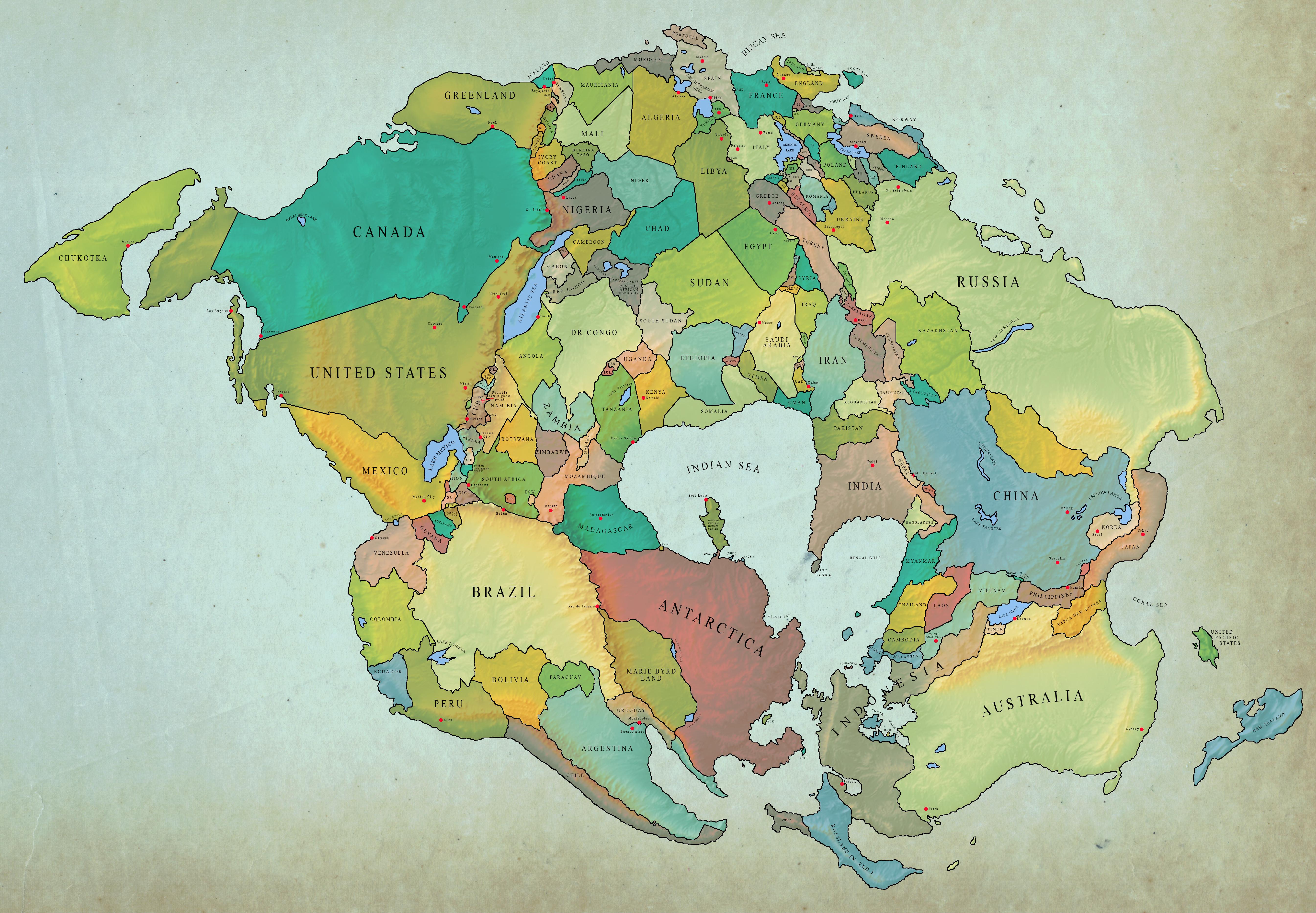
World Map 250 Million Years Later with Current Borders

Marcus Rodriguez
Historical Geography Expert
Marcus Rodriguez specializes in historical cartography and geographic data analysis. With a background in both history and geography, he brings unique...
Geographic Analysis
What This Map Shows\nThis visualization presents an intriguing perspective on the future of our planet, depicting a world map set 250 million years into the future while retaining the current international borders. It offers a unique glimpse into how tectonic shifts may alter the geography of our planet, even as our political boundaries remain in place. The juxtaposition of the ancient past with contemporary borders invites us to explore the dynamic nature of Earth's crust and the implications of geological movements on human societies.
Deep Dive into Plate Tectonics and Continental Drift\nUnderstanding this map requires a firm grasp of plate tectonics, a fundamental theory in geology that explains the movement of the Earth's lithosphere. The Earth's surface is divided into several large and small tectonic plates that float on the semi-fluid asthenosphere beneath. Over millions of years, these plates have been shifting and colliding, leading to the formation of continents, mountains, and ocean basins.
Interestingly, the configuration of continents we know today is a relatively recent development in the geological timeline. For instance, around 250 million years ago, the supercontinent Pangaea existed, with all the landmasses joined together. As the plates drift, they reshape the planet, creating new geographical features and changing ecosystems. So, what might our world look like in 250 million years?
Current scientific models suggest that continents will continue to drift towards the equator, potentially leading to new land formations and the merging of existing landmasses. For example, North America may move closer to Europe, while Africa could collide with Europe, forming a new mountain range. The Pacific Ocean may shrink as the Americas move westward, closing the gap between the continents and leading to significant climate shifts as ocean currents change.
Moreover, future plate movements could result in the formation of new rift valleys, where the crust is being pulled apart, and the emergence of new volcanic islands as magma rises to the surface. This continuous geological activity not only shapes the physical landscape but also impacts biodiversity, as species adapt to changing environments and ecosystems.
Regional Analysis\nWhen examining the map, we can break down the potential geological changes by region. In North America, the western coastline may see significant alterations as the Pacific Plate continues to move northward. Similarly, the eastern coastline could experience increased volcanic activity as the Atlantic Ocean widens.
In Asia, the collision between the Indian Plate and the Eurasian Plate could create towering new mountain ranges, while the ongoing drift of the Australian Plate towards the southeast may lead to the merging of it with the landmasses of Antarctica. This movement could drastically affect climate patterns in the region, leading to hotter and drier conditions in Australia and potentially altering the habitats of numerous species.
Europe's fate is equally fascinating; the Mediterranean Sea might close as Africa pushes northward, resulting in a completely redefined coastline. Countries like Italy and Greece could see their geographies drastically change, affecting everything from agriculture to tourism. Meanwhile, in South America, the Andes may rise even higher as the Nazca and South American plates continue their tectonic dance.
Significance and Impact\nUnderstanding these future geographical changes is crucial for several reasons. Firstly, it helps geographers and scientists predict potential natural disasters, such as earthquakes and volcanic eruptions, which could have dire consequences for human populations. Moreover, as climate patterns shift due to the changing landscapes, there will be implications for agriculture, ecosystems, and biodiversity.
Furthermore, recognizing the long-term geological changes can inform urban planning and infrastructure development. Governments and communities may need to adapt to new realities, considering how rising sea levels and shifting landmasses will impact their regions.
In conclusion, the world map set 250 million years into the future illustrates more than just a hypothetical scenario; it highlights the ongoing transformations of our planet. As we continue to study and understand these geological processes, we can better prepare for the future and appreciate the remarkable history embedded in our landscapes. So, have you ever thought about how the Earth you walk on today might look in a couple of hundred million years? It's a reminder of the ever-changing nature of our world and the intricate relationship between geology and human society.
Visualization Details
- Published
- August 8, 2025
- Views
- 134
Comments
Loading comments...