Geological Age Map of Europe

David Chen
Data Visualization Specialist
David Chen is an expert in transforming complex geographic datasets into compelling visual narratives. He combines his background in computer science ...
Geographic Analysis
What This Map Shows
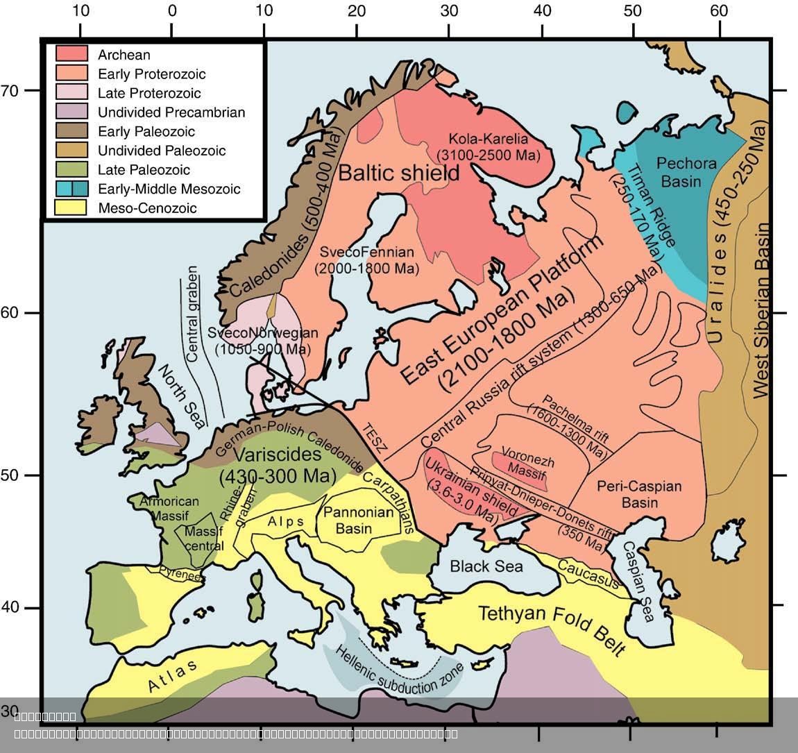
The "Simplified Geological Age Map of Europe and Surrounding Regions" provides a clear representation of the geological ages that have shaped the continent's diverse landscapes. This visualization categorizes regions based on their geological history, showcasing different rock formations and age distributions across Europe and adjacent areas. The map is not just a colorful depiction; it tells a story of Earth's past—one that includes the rise and fall of ancient seas, the formation of mountain ranges, and the evolution of ecosystems over millions of years.
Deep Dive into Geological Ages
Geological age refers to the time periods that encompass significant geological events, including the formation of the Earth’s crust, volcanic activity, and the fossilization of ancient organisms. Europe, with its varied geology, has a rich tapestry of rock formations that date back billions of years. These formations are categorized into different geological eras, such as the Precambrian, Paleozoic, Mesozoic, and Cenozoic.
Interestingly, the Precambrian era, which spans from the formation of the Earth around 4.6 billion years ago to about 541 million years ago, is represented in regions like Scandinavia, where some of the oldest rocks are found. The Baltic Shield, for instance, showcases ancient granites that provide insight into the Earth’s early crustal development.
Transitioning to the Paleozoic era (approximately 541 to 252 million years ago), we observe significant geological changes leading to the emergence of complex life forms. This period is prominently displayed across regions such as the British Isles and parts of Western Europe, where sedimentary rocks from ancient oceans are prevalent. The fossil record from this era reveals a wealth of marine life, including trilobites and brachiopods, which thrived in shallow seas.
Moving into the Mesozoic era (approximately 252 to 66 million years ago), Europe transformed dramatically. This era is often called the Age of Reptiles, and it's fascinating to note that the famous Jurassic and Cretaceous rock layers are rich in dinosaur fossils. Regions like southern France and the Alps exhibit limestone and sandstone formations from this time, offering clues about the ancient environments that existed before the mass extinction event that ended the dinosaurs.
Finally, the Cenozoic era (from about 66 million years ago to the present) marks the age of mammals and the rise of modern flora and fauna. The geological map reflects significant tectonic activity during this time, particularly in areas like the Alps and the Carpathians, where the collision of tectonic plates has created dramatic mountain ranges. This era also includes the development of fertile plains and river systems that have been crucial for human civilization.
Regional Analysis
When examining the map closely, it becomes evident that geological history varies significantly across Europe. For instance, the British Isles are primarily characterized by sedimentary rocks from the Paleozoic and Mesozoic eras, while Scandinavia boasts some of the oldest Precambrian rocks in the world. The contrast between these areas illustrates how geological processes such as erosion, sedimentation, and tectonics have differently affected regions over time.
In southern Europe, particularly the Mediterranean region, the geological landscape is marked by complex interactions between land and sea. The Apennine Mountains, which run through Italy, were formed during the Cenozoic era and are a prime example of how tectonic activity continues to shape the continent. In contrast, the flat plains of northern Europe highlight a different geological story, where glacial activity during the last Ice Age has left a lasting impact on the landscape, shaping fertile agricultural land.
Significance and Impact
Understanding the geological ages of Europe is not just an academic exercise; it has profound implications for natural resource management, environmental conservation, and even urban planning. For instance, the distribution of minerals and fossil fuels often correlates with specific geological formations. Regions rich in coal, oil, or natural gas can be traced back to particular geological ages, influencing energy policies and economic development.
Moreover, as climate change accelerates, knowing the geological history can help predict how landscapes will evolve. For example, areas with loose sedimentary rocks might be more susceptible to erosion, impacting human settlements and agriculture. As we move further into the 21st century, the lessons learned from geological history will be crucial in adapting to new environmental challenges and ensuring sustainable development.
In conclusion, the Simplified Geological Age Map of Europe is more than a tool for academics; it’s a vital resource for understanding our planet’s history and planning for its future. By studying geological ages, we not only comprehend the past but also gain insights that can significantly influence our present and future interactions with the Earth.
Visualization Details
- Published
- August 7, 2025
- Views
- 124
Comments
Loading comments...