Gaza Strip Map Before Israeli Disengagement 2005

Marcus Rodriguez
Historical Geography Expert
Marcus Rodriguez specializes in historical cartography and geographic data analysis. With a background in both history and geography, he brings unique...
Geographic Analysis
What This Map Shows
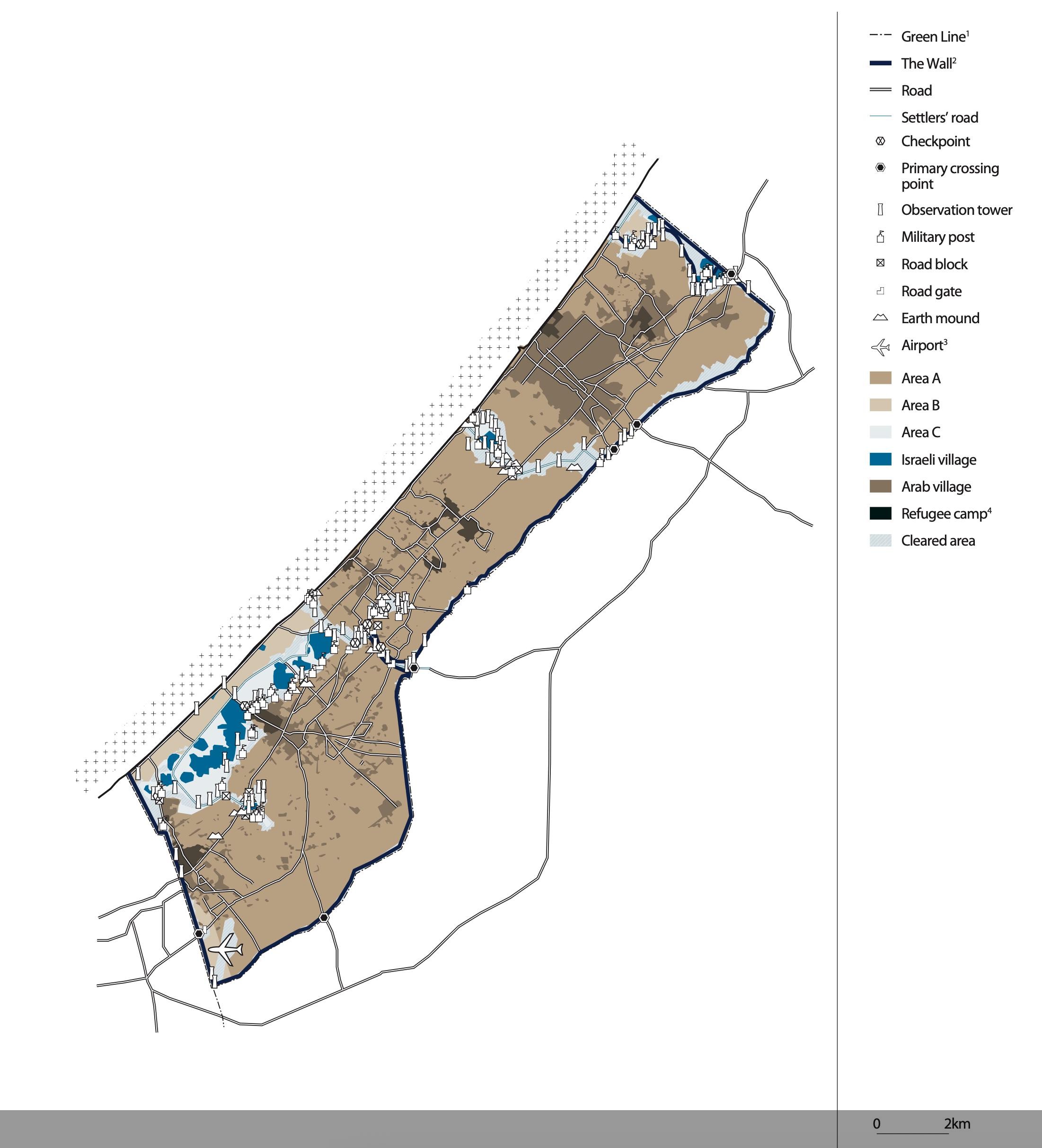
This map provides a detailed visual representation of the Gaza Strip prior to Israel's disengagement in 2005. It highlights the geographical layout of the region, including settlements, key infrastructure, and demographic distributions. Understanding this map is crucial for comprehending the socio-political dynamics that have shaped the area over the years.
As we delve into the specifics of the Gaza Strip, we'll explore its demographics, land use, and the historical context surrounding its development. This map serves as a snapshot of a pivotal moment in the region's history, revealing not just physical locations but also hinting at the complex narratives that define them.
Deep Dive into the Gaza Strip
The Gaza Strip, a narrow piece of land along the eastern coast of the Mediterranean Sea, is approximately 41 kilometers long and 6 to 12 kilometers wide. With a population density that is among the highest in the world, this small territory has been home to a diverse and often divided population. Before the disengagement in 2005, the Gaza Strip was characterized by a mix of urban centers, agricultural areas, and Israeli settlements.
Historically, the Gaza Strip has seen significant demographic shifts, particularly following the 1948 Arab-Israeli War, when many Palestinian refugees settled in the area. By 2005, the population had grown to around 1.4 million people, predominantly Palestinian Arabs, with a substantial percentage being refugees or descendants of refugees from earlier conflicts. This demographic reality has played a crucial role in shaping the social and political landscape of the region.
Interestingly, the map also illustrates the distribution of settlements—both Palestinian and Israeli—prior to the disengagement. At the time, there were 21 Israeli settlements in the Gaza Strip, housing around 8,000 settlers. These settlements were often heavily fortified, and their presence was a source of significant tension between the Israeli government and the Palestinian population.
The land use in the Gaza Strip varied considerably. Urban areas such as Gaza City and Khan Younis were densely populated, featuring a mix of residential structures, markets, and public services. Meanwhile, agricultural land was used for growing various crops, including vegetables and citrus fruits, which were significant for the local economy. The complex interplay between urban development and agricultural use highlights the ongoing struggle for resources in this densely populated area.
Regional Analysis
When analyzing the map, it’s essential to consider the different regions within the Gaza Strip. For instance, the northern part, including areas like Beit Hanoun and Jabalia, was known for its higher population density and more significant refugee presence. In contrast, the southern region, including Rafah, had fewer settlements and a more open landscape, yet still faced the repercussions of the socio-political strife.
Moreover, the proximity of these regions to key borders—most notably the border with Egypt and the Mediterranean Sea—has influenced their development. The southern region's access to Egypt made it a critical point for smuggling routes, which were prevalent even before the disengagement. In contrast, the northern areas were often subject to more direct military conflict, affecting infrastructure and population stability.
Significance and Impact
Understanding the Gaza Strip before the 2005 disengagement is vital for grasping the ongoing Israeli-Palestinian conflict and its implications for regional stability. The map serves as a reminder of a time when the demographic and geographic realities were in flux, setting the stage for future conflicts and negotiations.
What’s fascinating is how the disengagement itself has had lasting effects on the region. Following the withdrawal of Israeli settlers and military, the Gaza Strip experienced an increase in political tensions, which have only escalated in subsequent years. The implications of land use, population density, and settlement patterns remain relevant as we consider current events and the future of this contested territory.
As we look ahead, it’s crucial to ask: how will the demographic and geographic realities of the Gaza Strip continue to evolve? The interplay between historical context and contemporary realities will undoubtedly influence the peace process and the lives of millions of people in the region. The map from 2005 not only captures a moment in time but also serves as a foundation for understanding the complexities of ongoing disputes and aspirations for peace in this historically rich and tumultuous area.
Visualization Details
- Published
- August 5, 2025
- Views
- 124
Comments
Loading comments...