Migration Routes Map of Vandals, Sueves, and Alans

David Chen
Data Visualization Specialist
David Chen is an expert in transforming complex geographic datasets into compelling visual narratives. He combines his background in computer science ...
Geographic Analysis
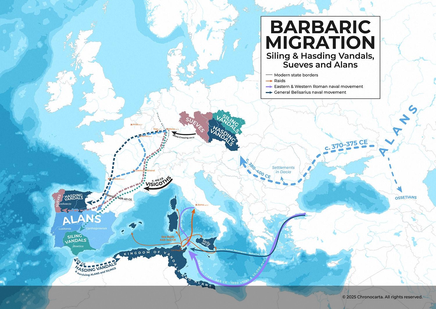
What This Map Shows\nThis map illustrates the migration routes and settlements of the Vandals, Sueves, and Alans during the tumultuous period of Late Antiquity, particularly around the collapse of the Western Roman Empire. It captures their journey as they fled the relentless pressure from the Huns, crossed the Rhine in 406 CE, and carved out new lives in Gaul and Hispania before establishing kingdoms in North Africa and northwest Iberia. The visualization highlights the complex interactions between these groups, showcasing the chaos of a world in flux.
Deep Dive into the Migration of the Vandals, Sueves, and Alans\nThe Vandals, Sueves, and Alans were pivotal players during the late Roman Empire's decline, each contributing to the shifting demographics and political landscape of Europe. The Vandals were split into two main factions: the Silings and the Hasdings. The Hasdings ultimately led the migration into North Africa, where they established the Kingdom of the Vandals and Alans. In contrast, the Silings initially settled in the Baetica region but were eventually absorbed by the Hasdings.
Interestingly, the Alans, an Iranian-speaking nomadic group, were also fleeing the Huns. Their journey was marked by a dramatic scattering across Europe. Some settled in the Caucasus region, while the majority moved westward, joining forces with the Vandals and Sueves. Their migration paths were not linear; they traversed through a series of territories that were in constant flux due to warfare and shifting allegiances.
As these groups moved through Gaul, they engaged in plunder, leaving a trail of devastation. The routes they took were not just pathways; they were shaped by the settlements they looted along the way. Historical accounts suggest that their movements were determined by the presence of resources, the strength of local defenses, and the ongoing conflicts with other tribes, such as the Visigoths. The interactions and conflicts among these groups further complicated their migrations.
In terms of territorial control, the borders depicted on the map are approximate, reflecting the blurry lines of ancient geopolitical realities. The constant shifts in allegiance and territory make it challenging to pinpoint exact locations. However, the visual representation provides a strong sense of their movements amid the chaos of that era.
The Vandals' establishment of a kingdom in North Africa marked a significant turning point. They became a formidable naval power, launching raids across the Mediterranean, including the infamous sack of Rome in 455 CE. Their ability to conduct such operations was rooted in their mobility and the strategic advantages granted by their previous migrations.
Regional Analysis\nExamining the regions depicted on the map reveals fascinating contrasts. In Gaul, the Vandals and Sueves encountered a mosaic of tribes and territories. Their plundering routes through Gaul were not uniform, as they navigated through various settlements, each with its own defenses and resources. The interactions with the Goths in Hispania also highlight the intricate web of alliances and conflicts that characterized this period.
Moving to North Africa, the Kingdom of the Vandals flourished for a while, becoming a center of power that challenged the Eastern Roman Empire. This kingdom, however, was eventually dismantled by the Eastern Romans under Justinian. The rapid collapse of the Vandal kingdom in 533 CE serves as a stark reminder of the fleeting nature of power during this era of instability.
In northwest Iberia, the Sueves established a kingdom that, at its height, was more extensive than shown on the map. Their reign lasted until 585 CE, demonstrating the complexity of tribal dynamics and territorial claims in the region. The Sueves' interactions with both the Romans and other Germanic tribes added layers to the cultural and political landscape of Iberia.
Significance and Impact\nUnderstanding the migration of the Vandals, Sueves, and Alans sheds light on the broader implications of these movements. They were not merely groups fleeing from one territory to another; they were part of a larger narrative of transformation in Europe. The establishment of new kingdoms and the ensuing cultural exchanges had lasting effects on the societies that followed.
In today's context, examining these migrations provides insights into current issues related to migration, identity, and cultural integration. The chaos of Late Antiquity mirrors modern challenges in understanding how population movements shape societies. As we navigate our own global migration issues, reflecting on the past can help us grasp the complexities and human experiences behind such transitions.
In conclusion, this map serves as a vital tool for understanding a significant historical moment—one that redefined borders, cultures, and identities across Europe and North Africa. The stories of the Vandals, Sueves, and Alans are not just tales of conquest and settlement; they are a testament to resilience and adaptation in the face of overwhelming change.
Visualization Details
- Published
- August 2, 2025
- Views
- 184
Comments
Loading comments...