European Colonial Presence in North America Map

Alex Cartwright
Senior Cartographer & GIS Specialist
Alex Cartwright is a renowned cartographer and geographic information systems specialist with over 15 years of experience in spatial analysis and data...
Geographic Analysis
What This Map Shows
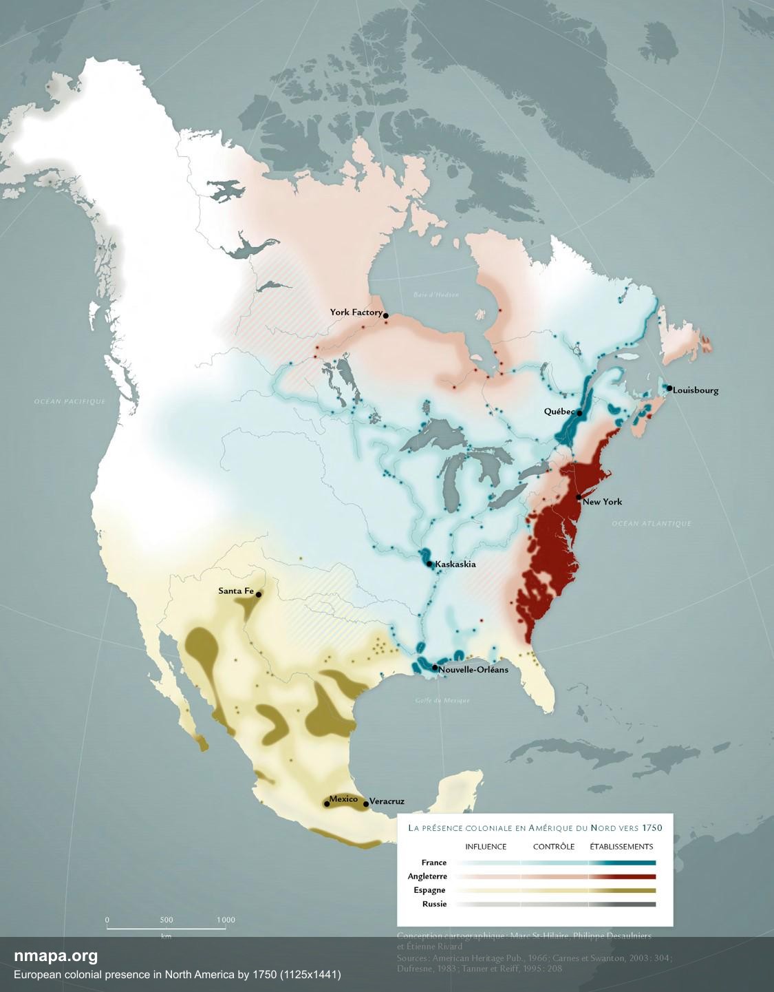
This map provides a detailed visualization of European colonial presence in North America by the year 1750, focusing particularly on the areas claimed by France and Britain. It highlights the vast expanse of New France, which, despite its immense claimed territory, illustrates a stark contrast between the areas under actual control and those effectively settled. The map clearly delineates the concentration of British settlements along the Atlantic Coast, showcasing a region burgeoning with European influence, while also emphasizing the French control predominantly along the riverbanks of the Mississippi and the Saint Lawrence. This visual representation not only underscores the territorial ambitions of these colonial powers but also hints at the dynamics of trade and interaction with Native tribes.
Deep Dive into Colonial Expansion in North America
Colonial expansion in North America during the 17th and 18th centuries was marked by distinct strategies employed by European powers. The French, for example, focused primarily on establishing trade networks and alliances with Native American tribes. They capitalized on the rich resources of the land, engaging in fur trade, which became a cornerstone of their economic model. Unlike the British, who aimed for settlement colonies, the French maintained a relatively low population density in their claimed territories, thus limiting their actual control to vital areas such as riverbanks and strategic trade routes.
Interestingly, the French claimed vast territories stretching from the Gulf of St. Lawrence to the Mississippi River, encompassing an area rich in natural resources. However, their settlements were few and far between, primarily concentrated around key locations like Quebec and Montreal, which served as hubs for trade and interaction. The relationship with Indigenous peoples was characterized by cooperation and mutual benefit, which was quite different from the British approach that often led to displacement and conflict.
The British, on the other hand, established a series of colonies along the Atlantic coast. By 1750, British settlements were densely packed, showcasing a stark contrast to the French model. Colonies like Virginia and Massachusetts exemplified a strategy focused on agricultural settlement, population growth, and territorial expansion. This led to a more aggressive assertion of control over land, often at the expense of Native American tribes. The British had a different vision for their North American territories, one that prioritized settlement and agricultural development, which laid the groundwork for future conflicts with Indigenous peoples and rival colonial powers.
Regional Analysis
When examining the map closely, we can discern significant regional differences in colonial presence and control. In New France, the geography dictated the French strategy. Rivers such as the Saint Lawrence and the tributaries of the Mississippi formed natural highways for trade and communication, allowing the French to establish strong relationships with Native tribes who relied on these waterways for their own sustenance and trade. For example, the Great Lakes region became a vital area for fur trading and served as a point of contact between various Native tribes and French traders.
In contrast, the British colonies along the eastern seaboard were characterized by a more diverse economy that included agriculture, trade, and increasing urbanization. The cities of Boston, New York, and Philadelphia emerged as bustling centers of commerce, reflecting the British approach to colonization, which encouraged settlement and economic development. Interestingly, the British colonial model fostered a robust population growth that would, in the long run, lead to significant demographic shifts and tensions with Indigenous populations.
Significance and Impact
Understanding the colonial presence in North America by 1750 is crucial for grasping the historical context of European expansion and its lasting impacts. The disparities shown on the map reveal not just the ambitions of colonial powers but also the complexities of cultural exchanges, trade, and conflict with Native American tribes. The French approach, which was more integrative, starkly contrasts with the British model that often led to displacement and cultural erasure.
Today, these historical patterns of colonization continue to influence cultural and geographical identities in North America. The ongoing discussions around land rights, cultural preservation, and Indigenous sovereignty are rooted in this complex history. As we reflect on these dynamics, one might wonder how these early colonial strategies have shaped modern geopolitical landscapes and relationships between nations and Indigenous communities. The legacy of these colonial practices raises questions about the future of land use, resource management, and cultural recognition in North America.
By analyzing the map of European colonial presence, we not only gain insight into the past but also a framework for understanding the present and future challenges that arise from this rich, albeit tumultuous history.
Visualization Details
- Published
- August 2, 2025
- Views
- 146
Comments
Loading comments...