Azerbaijan-Turkey-NATO Corridor Map

David Chen
Data Visualization Specialist
David Chen is an expert in transforming complex geographic datasets into compelling visual narratives. He combines his background in computer science ...
Geographic Analysis
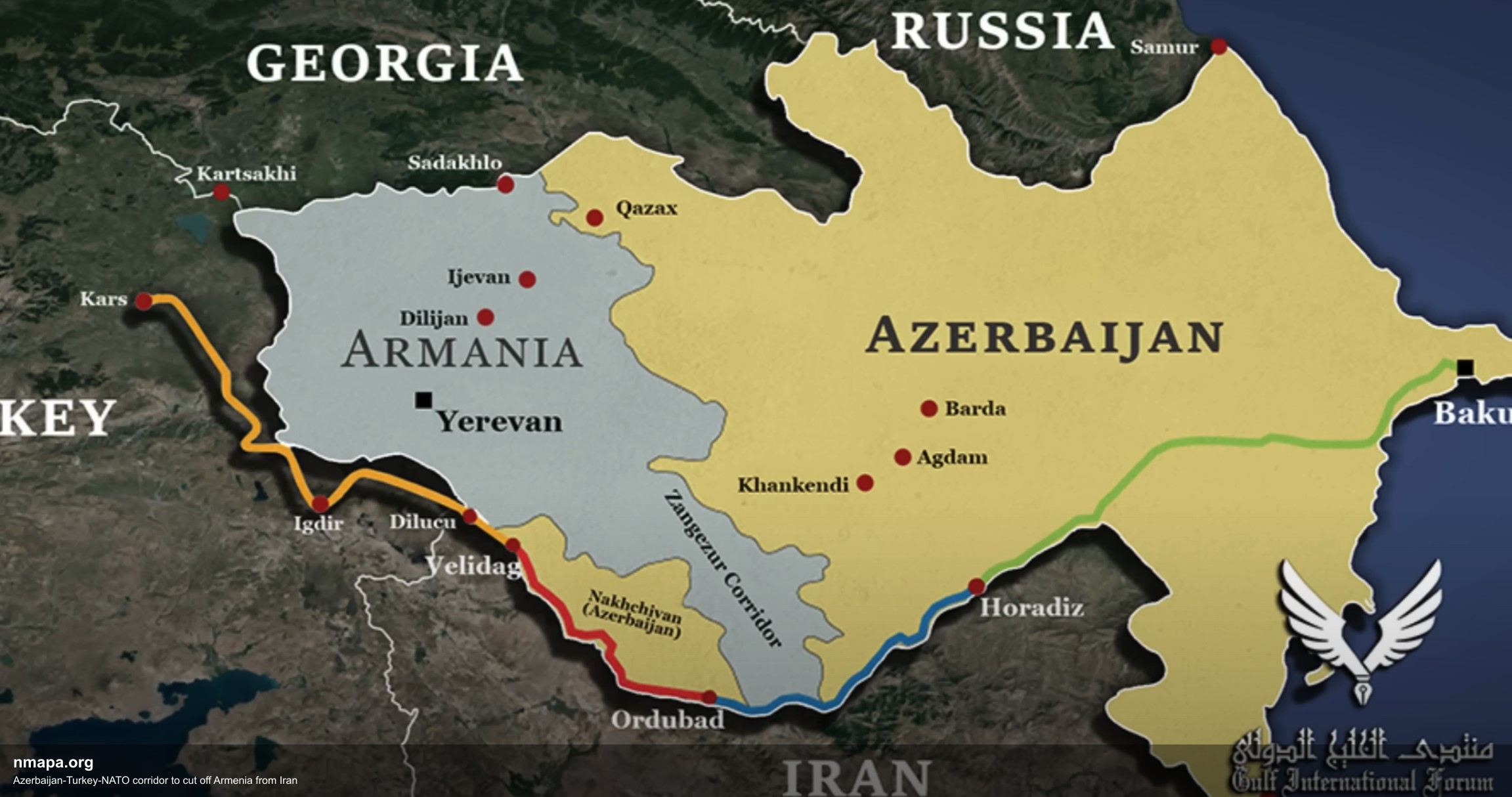
The Azerbaijan-Turkey-NATO Corridor Map illustrates a strategic pathway intended to reinforce military and economic ties between Azerbaijan and Turkey while potentially isolating Armenia from Iran. This visualization highlights key routes, infrastructures, and geopolitical boundaries that define this corridor, which is significant in the context of regional security dynamics.
The map delineates the corridor's trajectory, showcasing major transportation links such as highways and railways that facilitate the movement of troops and goods. Notably, the corridor runs close to the border of Armenia, which raises concerns about the implications for Armenian access to Iranian resources and support. The visualization provides a clear representation of how these routes can be utilized for both military and logistical purposes, underscoring the strategic interests of Azerbaijan and Turkey within the broader NATO framework.
Geographically, the corridor is positioned in a critical zone that connects the Caucasus region with the Middle East. This area has long been a flashpoint for regional conflicts, influenced by historical tensions between Armenia and Azerbaijan, particularly over the Nagorno-Karabakh region. The map emphasizes the importance of geography in shaping conflict dynamics, as the physical landscape often dictates the feasibility of military operations and the flow of resources.
Historically, the relationship between Armenia, Azerbaijan, and Turkey has been marked by conflict and rivalry. The establishment of this corridor can be seen as an attempt by Azerbaijan and Turkey to solidify their influence in the region and counterbalance Armenia's ties with Iran. The visualization serves as a reminder of how historical grievances and alliances are intricately linked to geographical factors, which can lead to escalated tensions and conflict.
In terms of regional patterns, the Azerbaijan-Turkey-NATO corridor reflects broader geopolitical strategies involving alliances and military partnerships. The map not only reveals the physical routes but also highlights the strategic interests at play, including energy security, territorial integrity, and military positioning. Understanding these patterns is crucial for analyzing potential future conflicts and the stability of the region.
The educational value of this map lies in its ability to convey complex geographical concepts in a visually accessible manner. It allows viewers to grasp the significance of geographical factors in international relations, particularly how borders, territories, and access routes can influence the balance of power among nations. Such visualizations can enhance geographic literacy by illustrating the intertwined nature of geography and politics.
Moreover, this type of visualization aids in understanding the broader geographical concepts of connectivity, territoriality, and resource distribution. It encourages viewers to consider how geography shapes human behavior, political strategies, and the potential for conflict. In an era where geopolitical tensions are rising, tools like this map become essential for comprehending the nuances of regional relationships and the implications for global peace and security.
In conclusion, the Azerbaijan-Turkey-NATO Corridor Map is more than just a representation of routes; it is a critical tool for understanding the complex interplay of geography, history, and politics in a region poised for potential conflict. As the situation evolves, such visualizations will continue to be invaluable for policymakers, scholars, and anyone interested in the geographical dimensions of international relations.
Visualization Details
- Published
- August 1, 2025
- Views
- 134
Comments
Loading comments...