Japanese Propaganda Map of China in 1940

Alex Cartwright
Senior Cartographer & GIS Specialist
Alex Cartwright is a renowned cartographer and geographic information systems specialist with over 15 years of experience in spatial analysis and data...
Geographic Analysis
What This Map Shows
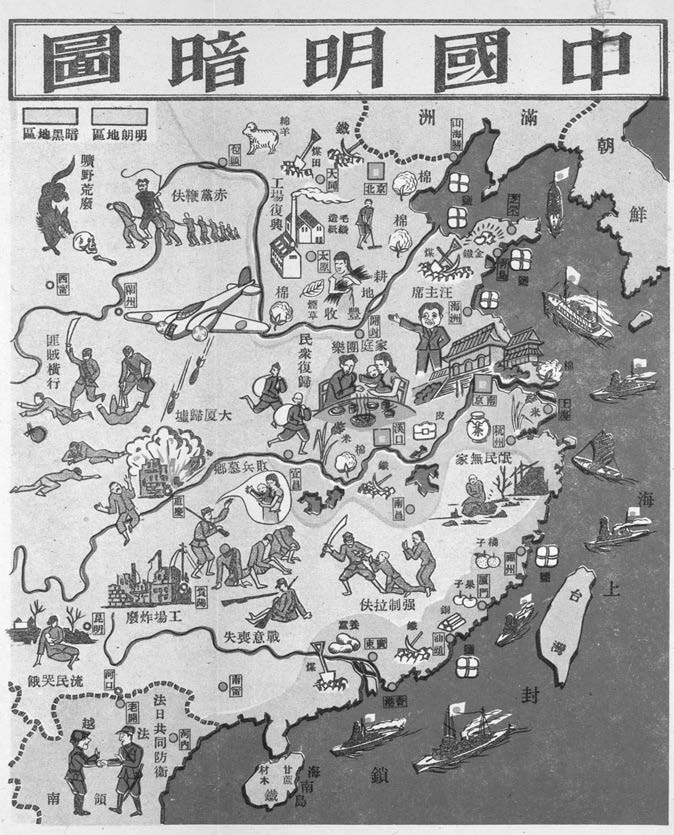
The "Map of Light and Darkness in China" from 1940 presents a stark visual representation of the geopolitical landscape during the Second Sino-Japanese War. This propaganda map delineates areas of Japanese occupation in a lighter shade, contrasting sharply with the darker regions that were under the control of the Kuomintang (KMT). This visualization effectively conveys not just territorial control but also the prevailing narrative of dominance that Japan sought to project at that time.
Deep Dive into Japanese Occupation and KMT Control
The map serves as a historical record of a turbulent period in China’s history, highlighting the intense struggle for power between the Japanese forces and the KMT. During the late 1930s and into the early 1940s, Japan sought to expand its empire across Asia, and China was a primary target. By 1940, Japanese authorities had successfully occupied significant portions of eastern China, including major cities like Beijing, Shanghai, and Nanjing. This occupation was characterized by military aggression and was often accompanied by brutal repression of the local population.
Interestingly, the KMT, led by Chiang Kai-shek, was engaged in a fierce resistance against Japanese advances. The KMT-controlled areas, depicted in dark tones on the map, included regions in southwestern and central China. These areas were not just geographical spaces but also represented the heart of China's nationalistic spirit. The KMT aimed to unify the country and fend off foreign aggression, which made their control essential in maintaining Chinese sovereignty.
One of the most significant aspects of this map is how it illustrates the divide in resources, infrastructure, and civilian safety. The Japanese-occupied territories were often prioritized for military supply lines and administrative control, leading to heightened economic exploitation. In contrast, KMT-controlled areas, while also facing challenges, were better positioned to garner support from the local populace given their nationalistic agenda. This juxtaposition of light and darkness on the map can be seen as more than just a territorial divide; it symbolizes the ideological struggle between imperialism and nationalism.
Regional Analysis
When we analyze the map regionally, several patterns emerge. For example, the coastal regions, which were primarily occupied by the Japanese, were crucial for their strategic military operations. This includes ports that facilitated the flow of supplies and reinforcements from Japan. In contrast, the interior regions, like Sichuan and Yunnan, remained largely under KMT control and became vital for guerrilla warfare and resistance efforts.
Moreover, the Yangtze River served as an important geographic feature during this conflict. It functioned as a natural barrier and a crucial transportation route, influencing military strategies on both sides. The varying levels of control over river systems also impacted the distribution of resources and the movement of troops. Have you noticed how geography often plays a pivotal role in warfare?
Interestingly, the map also reflects the diverse demographic landscape of China during this period. In the Japanese-occupied areas, the population faced significant hardships, including violence, forced labor, and displacement. Conversely, regions under KMT control had a more stable social order, albeit with ongoing military threats. This disparity highlights how geography and control impacted not just military strategies but also the everyday lives of millions.
Significance and Impact
The significance of this map extends beyond its immediate historical context; it serves as a reminder of the complexities of warfare and national identity. The propaganda aspect is crucial as well; by depicting occupied areas in light, the Japanese aimed to project an image of stability and control, even as resistance simmered in the darker regions. What's fascinating is how maps like this can influence public perception and sentiment, shaping narratives around patriotism and resistance.
In contemporary times, the legacies of these territorial conflicts still resonate in Sino-Japanese relations. Understanding this historical map allows us to appreciate the long-standing implications of wartime actions and territorial disputes. As we look toward the future, it’s essential to consider how geography continues to shape political landscapes and the importance of historical awareness in fostering better international relations.
In conclusion, the "Map of Light and Darkness in China" is not merely a historical artifact but a vivid illustration of the struggles for power, identity, and survival during one of the most tumultuous times in Chinese history. Its insights remain relevant today, providing a lens through which we can examine the complexities of human geography and international relations.
Visualization Details
- Published
- September 29, 2025
- Views
- 46
Comments
Loading comments...